Related Research Articles

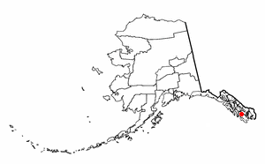
Southeast Alaska, colloquially referred to as the Alaska(n) Panhandle, is the southeastern portion of the U.S. state of Alaska, bordered to the east and north by the northern half of the Canadian province of British Columbia. The majority of Southeast Alaska's area is part of the Tongass National Forest, the United States' largest national forest. In many places, the international border runs along the crest of the Boundary Ranges of the Coast Mountains. The region is noted for its scenery and mild, rainy climate.
Naukati Bay is a census-designated place (CDP) in the Prince of Wales-Hyder Census Area of the Unorganized Borough of the U.S. state of Alaska. The population was 113 at the 2010 census, down from 135 in 2000.

Sheldon Jackson College (SJC) was a small private college located on Baranof Island in Sitka, Alaska, United States. Founded in 1878, it was the oldest institution of higher learning in Alaska and maintained a historic relationship with the Presbyterian Church. The college was named in honor of Rev. Sheldon Jackson, an early missionary and educational leader in Alaska.
Admiralty Island is an island in the Alexander Archipelago in Southeast Alaska, at 57°44′N134°20′W. It is 145 km (90 mi) long and 56 km (35 mi) wide with an area of 4,264.1 km2 (1,646.4 sq mi), making it the seventh-largest island in the United States and the 132nd largest island in the world. It is one of the ABC islands in Alaska. The island is nearly cut in two by the Seymour Canal; to its east is the long, narrow Glass Peninsula. Most of Admiralty Island—955,747 acres (3,868 km2)—is protected as the Admiralty Island National Monument administered by the Tongass National Forest. The Kootznoowoo Wilderness encompasses vast stands of old-growth temperate rainforest. These forests provide some of the best habitat available to species such as brown bears, bald eagles, and Sitka black-tailed deer.
Salisbury Sound is a sound between the north shore of Kruzof Island and the southwestern end of Chichagof Island in the Alexander Archipelago in Southeast Alaska. It is about 40 km (25 mi) northwest of the city of Sitka, and within the limits of Sitka City and Borough.
Kruzof Island is an island in the Alexander Archipelago in southeastern Alaska at 57°10′14″N135°40′29″W. It is about 16 km (10 mi) west of Sitka, and is part of the City and Borough of Sitka. It was named in 1805 by Captain U.T. Lisianski as Crooze Island, after a Russian Admiral. It hosts the region's only volcano, Mount Edgecumbe.
Japonski Island is a small island in the city of Sitka in the Alexander Archipelago of southeastern Alaska, United States. It lies across the Sitka Channel from Sitka's central business district.
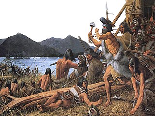
The Battle of Sitka was the last major armed conflict between Russians and Alaska Natives, and was initiated in response to the destruction of a Russian trading post two years before. The primary combatant groups were the Kiks.ádi Clan of Sheetʼká Xʼáatʼi of the Tlingit nation and agents of the Russian-American Company assisted by the Imperial Russian Navy.
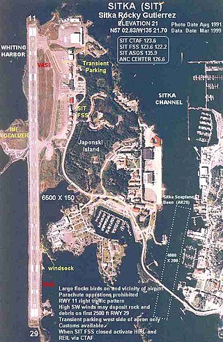
Sitka Rocky Gutierrez Airport is a state-owned, public-use airport located west of the central business district of Sitka, a city and borough in the U.S. state of Alaska.

Baranof Warm Springs is a small, primarily seasonally-occupied community located in the city and borough of Sitka, Alaska, on the eastern side of Baranof Island, from which it likely derives its name, in the Alexander Archipelago. It is occasionally referred to simply as Baranof. Baranof Warm Springs is located at 57°05′22″N134°49′59″W.

The Sitka Channel is a strait that separates Japonski Island from Baranof Island in Alaska.
Warm Springs Bay is a 2.4 mile-long bay located just outside the small community of Baranof Warm Springs on Baranof Island in the Alexander Archipelago, Alaska. Warm Springs Bay receives the outflow of Baranof Lake and Baranof River. Warm Springs Bay is located at 57°04′49″N134°48′12″W.
Eastern Channel is a body of deep water adjacent to the southern half of Sitka, Alaska. It is the best suited of three channels for large ships to approach the harbor in Sitka.
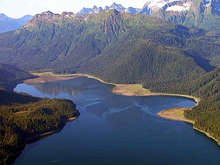
Silver Bay, or Gaǥeit', in the Tlingit language, is a deep water fjord located southeast of Sitka, Alaska, United States, that indents Baranof Island. It was named through a United States Coast and Geodetic Survey translation of Bukhta Serebryanikova, a name published first by Captain Tebenkov of the Imperial Russian Navy in 1852.
Partofshikof Island is an island in the Alexander Archipelago of southeastern Alaska, United States. It is part of the City and Borough of Sitka, and lies between the northern part of Kruzof Island and the northwestern part of Baranof Island. It is separated from Kruzof Island by Sukoi Inlet, and separated from Baranof Island by Neva Strait. Partofshikof Island has a land area of 34.177 km2 and no resident population.
Minett Islet is a small islet in Jamestown Bay, Sitka Sound in Alaska. It is named for United States Navy officer and Governor of American Samoa Henry Minett.

Baranof Island is an island in the northern Alexander Archipelago in the Alaska Panhandle, in Alaska. The name Baranof was given in 1805 by Imperial Russian Navy captain U. F. Lisianski to honor Alexander Andreyevich Baranov. It was called Sheet’-ká X'áat'l by the native Tlingit people. It is the smallest of the ABC islands of Alaska. The name "Baranof" was given to the island in 1805, by the Imperial Russian Navy Captain U.F. Lisianski, in honor of the Russian Alaskan governor Alexander Andreyevich Baranov. The indigenous group native to the island, the Tlingit, named the island Shee Atika. Baranof island is home to a diverse ecosystem, which made it a prime location for the fur trading company, the Russian American Company. Russian occupation in Baranof Island impacted not only the indigenous population as well as the ecology of the island, but also led to the United States' current ownership over the land.
Sitka Seaplane Base is a public use seaplane base owned by and located in Sitka, a city and borough in the U.S. state of Alaska. It is included in the National Plan of Integrated Airport Systems for 2011–2015, which categorized it as a general aviation facility. This seaplane base is located near the Sitka Rocky Gutierrez Airport.

Coast Guard Air Station Sitka, Commanded by Commander Vincent J. Jansen, is an Air Station of the United States Coast Guard located in Sitka, Alaska. The station was originally established on Annette Island in March 1944, until relocating to Sitka in 1977. Early aircraft consisted of Grumman G-21's, PBY’s, HU-16’s, HH-52’s, and HH-3 Pelicans. Primary missions performed by the air station are Search and Rescue (SAR), law enforcement, and logistics covering the Southeast part of Alaska. Area of responsibility encompasses approximately 180,000 square miles of water and land extending across Southeast Alaska from Dixon Entrance to Icy Bay (Alaska), and from the Alaskan-Canadian border to the central Gulf of Alaska. This includes 12,000 miles of coastline distinguished by a rugged coast, mountainous terrain, severe weather, and many remote villages.
Nameless Island is an island in Sitka, Alaska, United States.
References
- ↑ U.S. Army Corps of Engineers. Southeast Alaska Harbors, Sitka: Environmental Impact Statement (1992), p. 156 ("There are no significant freshwater streams flowing into Jamestown Bay. The bay has been separated from Indian River by a gravel causeway constructed from Sawmill Creek Road to Cannon Island, which isolates Jamestown Bay from the estuarine influence of Indian River.")
- ↑ Baker, Marcus. Geographic Dictionary of Alaska, p. 114 (1901)
- "Cannon Island". Geographic Names Information System . United States Geological Survey, United States Department of the Interior . Retrieved January 21, 2019.
Coordinates: 57°02′36″N135°18′01″W / 57.04333°N 135.30028°W
| | This article about a location in the City and Borough of Sitka, Alaska is a stub. You can help Wikipedia by expanding it. |