Upper Catesby is a hamlet in the civil parish of Catesby, Northamptonshire, about 3.5 miles (5.6 km) southwest of Daventry. The hamlet is about 550 feet (170 m) above sea level, at the top of a northwest-facing escarpment. The population is included in the civil parish of Hellidon.
Canons Ashby Priory was an Augustinian priory at Canons Ashby, Northamptonshire, England.

Lower Catesby is a hamlet in the civil parish of Catesby, Northamptonshire, about 4 miles (6.4 km) southwest of Daventry. Lower Catesby is beside the nascent River Leam, which rises about 1 mile (1.6 km) to the south in the parish of Hellidon. The Jurassic Way long-distance footpath passes through Lower Catesby. The population of the hamlet is included in the civil parish of Hellidon.
Hannington is a village in West Northamptonshire in England. At the time of the 2011 census the parish's population was 251 people.

Dodford is a village in West Northamptonshire, England. Prior to local government changes in 2021 it was within the Weedon Ward of Daventry District. The village is just north of the A45 road 1+1⁄2 miles (2.4 km) west of Weedon. The population of the civil parish at the 2011 Census was 203. It is 3+1⁄2 miles (5.6 km) east of Daventry and 10 miles (16 km) west of Northampton. It is also close to junction 16 of the M1 motorway. The parish consists of some 1,384 acres (560 ha) and is bounded on the east by the A5 trunk road which is the old Roman road of Watling Street. Most of the village and parish sits astride the valley of an east-flowing stream which is a tributary of the River Nene.

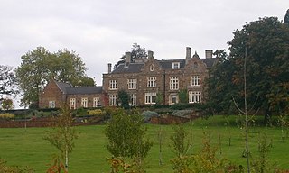
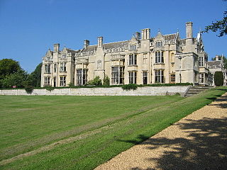
Nocton is a village and civil parish in the North Kesteven district of Lincolnshire, England. It is situated on the B1202 road, 7 miles (11 km) south-east from Lincoln city centre. The population of the civil parish at the 2011 census was 819. To the east of the village is Nocton Fen with its small settlement of Wasps Nest. To the west of the village, situated at the junction of Wellhead Lane and the B1188 road, is Nocton Top Cottages consisting of eight further dwellings. At the south of the village are the remains of Nocton Hall, and 1 mile (2 km) to the east the earthwork remains of Nocton Park Priory.

Sulgrave is a village and civil parish in West Northamptonshire, England, about 5 miles (8 km) north of Brackley. The village is just south of a stream that rises in the parish and flows east to join the River Tove, a tributary of the Great Ouse.
Moreton Pinkney is a village and civil parish in West Northamptonshire, about 7.5 miles (12 km) north of Brackley. The 2011 Census recorded the parish's population as 371.
Maxstoke is a hamlet and civil parish in the North Warwickshire district of the county of Warwickshire, England. It is situated approximately 2.5 miles north of Meriden. Maxstoke and the parish of Maxstoke were established in the hundred of Hemlingford.

Hellaby is a settlement and civil parish in the Metropolitan Borough of Rotherham, South Yorkshire, England. The population of the Civil Parish at the 2011 census was 825. It is situated 4.5 miles (7.2 km) east from the centre of Rotherham and forms a continuous urban area with Maltby, separated from the rest of Rotherham by Junction 1 of the M18. It is situated by Hellaby Brook and, whilst signposted as "Hellaby Village", the parish has no school, church or post office.

Althorp is a lost village within the grounds of the Althorp estate in the English county of Northamptonshire. The village is recorded in the Domesday Book. In the 15th century, the manor was held by the Catesby family who were probably responsible for clearing the settlement, for by 1505, the records show that there were no tenants. In 1508, the parish, including the cleared settlement of Althorp, was sold to John Spencer of Wormleighton in Warwickshire. By 1577, the land in the parish had been divided into four large sheep pastures. Althorp remains a civil parish.

The village of Braunston Cleves or Fawcliff formerly stood north of the village of Braunston in the English county of Northamptonshire at its border with Warwickshire. It has long been a "lost village", having no standing buildings, but its position and the topography of its street and houses can be traced from the irregularities of the ground where it formerly stood. It was on the southwest slope of Cleve's Hill within Braunston parish: it appears to have been occupied in late Anglo-Saxon and early post-Conquest times. Nothing is known of why the village was deserted but it had certainly been destroyed by the 18th century.

The lost village of Braunstonbury lies in low ground south-west of the village of Braunston in the English county of Northamptonshire. Its site is on the eastern bank of the River Leam, which also marks the border between Northamptonshire and Warwickshire. Adjacent to the site on the west side of the river Leam is the site of the lost village of Wolfhampcote which straddled the county border of both counties.
The lost village of Coton is located around the environs of the hamlet of Coton and Coton Manor House in the English county of Northamptonshire.

The lost village of Church Charwelton lies south-east of the village of Charwelton in the English county of Northamptonshire. Its site is on the north-east bank of the River Cherwell. The Jurassic Way long-distance footpath passes across the site.
Rushton is a village and civil parish in Northamptonshire. It is about 2 miles (3.2 km) north-east of Rothwell and 3 miles (4.8 km) north-west of Kettering. The parish covers 3,200 acres (1,300 ha) and is situated on both sides of the River Ise. It contains the sites of three deserted settlements, details of which are set out below.

Culworth is a village and civil parish about 7 miles (11 km) north of Brackley in West Northamptonshire, England. Culworth is also about 7 miles (11 km) northeast of the north Oxfordshire town of Banbury.
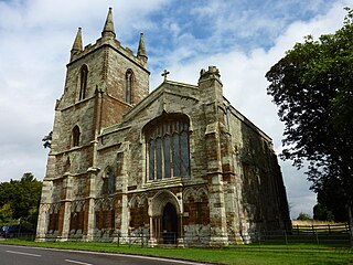
Catesby Priory was a priory of Cistercian nuns at Lower Catesby, Northamptonshire, England. It was founded in about 1175 and dissolved in 1536.

