The arrondissement of Auch is an arrondissement of France in the Gers department in the Occitanie region. Since the January 2017 reorganization of the arrondissements of Gers, it has 134 communes.
The following is a list of the 17 cantons of the Gers department, in France, following the French canton reorganisation which came into effect in March 2015:
The canton of Montréal is a former administrative division in the Gers department, which is itself a component of the region Midi-Pyrénées, in the area formerly called Gascony, France. It was disbanded following the French canton reorganisation which came into effect in March 2015. It consisted of 9 communes, which joined the canton of Armagnac-Ténarèze in 2015.
The canton of Armagnac-Ténarèze is an administrative division of the Gers department, southwestern France. It was created at the French canton reorganisation which came into effect in March 2015. Its seat is in Eauze.
The canton of L'Isle-Jourdain is an administrative division of the Gers department, southwestern France. Its borders were modified at the French canton reorganisation which came into effect in March 2015. Its seat is in L'Isle-Jourdain.
The canton of Adour-Gersoise is an administrative division of the Gers department, southwestern France. It was created at the French canton reorganisation which came into effect in March 2015. Its seat is in Riscle.
The canton of Astarac-Gimone is an administrative division of the Gers department, southwestern France. It was created at the French canton reorganisation which came into effect in March 2015. Its seat is in Masseube.
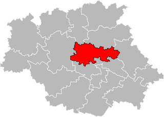
The canton of Auch-2 is an administrative division of the Gers department, southwestern France. It was created at the French canton reorganisation which came into effect in March 2015. Its seat is in Auch.
The canton of Auch-3 is an administrative division of the Gers department, southwestern France. It was created at the French canton reorganisation which came into effect in March 2015. Its seat is in Auch.
The canton of Baïse-Armagnac is an administrative division of the Gers department, southwestern France. It was created at the French canton reorganisation which came into effect in March 2015. Its seat is in Condom.
The canton of Fezensac is an administrative division of the Gers department, southwestern France. It was created at the French canton reorganisation which came into effect in March 2015. Its seat is in Vic-Fezensac.
The canton of Fleurance-Lomagne is an administrative division of the Gers department, southwestern France. It was created at the French canton reorganisation which came into effect in March 2015. Its seat is in Fleurance.
The canton of Gascogne-Auscitaine is an administrative division of the Gers department, southwestern France. It was created at the French canton reorganisation which came into effect in March 2015. Its seat is in Preignan.
The canton of Gimone-Arrats is an administrative division of the Gers department, southwestern France. It was created at the French canton reorganisation which came into effect in March 2015. Its seat is in Gimont.
The canton of Grand-Bas-Armagnac is an administrative division of the Gers department, southwestern France. It was created at the French canton reorganisation which came into effect in March 2015. Its seat is in Nogaro.
The canton of Lectoure-Lomagne is an administrative division of the Gers department, southwestern France. It was created at the French canton reorganisation which came into effect in March 2015. Its seat is in Lectoure.
The canton of Mirande-Astarac is an administrative division of the Gers department, southwestern France. It was created at the French canton reorganisation which came into effect in March 2015. Its seat is in Mirande.

The canton of Pardiac-Rivière-Basse is an administrative division of the Gers department, southwestern France. It was created at the French canton reorganisation which came into effect in March 2015. Its seat is in Plaisance.
The canton of Val de Save is an administrative division of the Gers department, southwestern France. It was created at the French canton reorganisation which came into effect in March 2015. Its seat is in Samatan.
The canton of Vallées de l'Ousse et du Lagoin is an administrative division of the Pyrénées-Atlantiques department, southwestern France. It was created at the French canton reorganisation which came into effect in March 2015. Its seat is in Pontacq.

