
The arrondissement of Besançon is an arrondissement of France in the Doubs department in the Bourgogne-Franche-Comté region. In 2009 the two cantons of Pierrefontaine-les-Varans and Vercel that previously belonged to the arrondissement of Besançon were added to the arrondissement of Pontarlier. It has 258 communes.

The arrondissement of Pontarlier is an arrondissement of France in the Doubs department in the Bourgogne-Franche-Comté region. It was expanded in 2009 with the two cantons of Pierrefontaine-les-Varans and Vercel from the arrondissement of Besançon, and the canton of Russey from the arrondissement of Montbéliard. It has 149 communes.
The following is a list of the 19 cantons of the Doubs department, in France, following the French canton reorganisation which came into effect in March 2015:
The canton of Fère-en-Tardenois is an administrative division in northern France. At the French canton reorganisation which came into effect in March 2015, the canton was expanded from 23 to 84 communes :
The canton of Ribemont is an administrative division in northern France. At the French canton reorganisation which came into effect in March 2015, the canton was expanded from 15 to 52 communes:

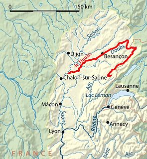
The GR 59 Grande Randonnée long-distance footpath in France connects two mountain ranges across relatively low-lying terrain. In the north, it begins at Ballon d'Alsace in the Vosges at a height of over 1000m. It loses height rapidly, and runs south-south-west through the département of the Haute-Saône to Besançon on the River Doubs, in the département of the same name. It then follows a circuitous route, partly along the River Loue to Lons-le-Saunier in the département of Jura. At St-Amour just south of Lons, the GR 9 splits from the GR 59 and takes a more easterly route, near the Swiss border, while the GR59 continues into the regions of Bugey and Revermont in the département of Ain, finally rejoining the GR 9 near Yenne on the banks of the Rhône; the GR 9 then continues to the Mediterranean at St-Tropez.
The flood of Doubs river was the biggest flooding in the history of the Doubs river (France); the water rose up to nearly 10 metres above the usual level, January 21, 1910. The principal departements affected were the département of Doubs, the département of Jura and also the département of Saône et Loire. At least one person was killed, and many others may have been killed because of this flood.
The canton of Bavans is an administrative division of the Doubs department, eastern France. It was created at the French canton reorganisation which came into effect in March 2015. Its seat is in Bavans.
The canton of Ornans is an administrative division of the Doubs department, eastern France. Its borders were modified at the French canton reorganisation which came into effect in March 2015. Its seat is in Ornans.
The canton of Saint-Vit is an administrative division of the Doubs department, eastern France. It was created at the French canton reorganisation which came into effect in March 2015. Its seat is in Saint-Vit.
The canton of Valdahon is an administrative division of the Doubs department, eastern France. It was created at the French canton reorganisation which came into effect in March 2015. Its seat is in Valdahon.
The canton of Morteau is an administrative division of the Doubs department, eastern France. Its borders were modified at the French canton reorganisation which came into effect in March 2015. Its seat is in Morteau.
The canton of Tavaux is an administrative division of the Jura department, eastern France. It was created at the French canton reorganisation which came into effect in March 2015. Its seat is in Tavaux.
The canton of Argonne Suippe et Vesle is an administrative division of the Marne department, northeastern France. It was created at the French canton reorganisation which came into effect in March 2015. Its seat is in Sainte-Menehould.
The canton of Mourmelon-Vesle et Monts de Champagne is an administrative division of the Marne department, northeastern France. It was created at the French canton reorganisation which came into effect in March 2015. Its seat is in Mourmelon-le-Grand.
The canton of Stenay is an administrative division of the Meuse department, northeastern France. Its borders were modified at the French canton reorganisation which came into effect in March 2015. Its seat is in Stenay.
The canton of Port-sur-Saône is an administrative division of the Haute-Saône department, northeastern France. Its borders were modified at the French canton reorganisation which came into effect in March 2015. Its seat is in Port-sur-Saône.
The canton of Saint-Loup-sur-Semouse is an administrative division of the Haute-Saône department, northeastern France. Its borders were modified at the French canton reorganisation which came into effect in March 2015. Its seat is in Saint-Loup-sur-Semouse.

Communauté d'agglomération du Grand Besançon is the communauté d'agglomération, an intercommunal structure, centred on the city of Besançon. It is located in the Doubs department, in the Bourgogne-Franche-Comté region, northeastern France. It was created in December 2000. Its population was 193,187 in 2016, of which 116,466 in Besançon proper.

