Related Research Articles
Colombier or Colombiers may refer to:

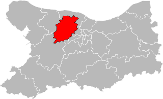
The arrondissement of Lyon is an arrondissement of France in the Auvergne-Rhône-Alpes region. It has 135 communes. Its population is 1,585,411 (2016), and its area is 1,534.6 km2 (592.5 sq mi).

The Arrondissement of Bayeux an arrondissement of France in the Calvados department in the Normandy region. It has 123 communes. Its population is 73,896 (2016), and its area is 976.6 km2 (377.1 sq mi).

The arrondissement of Montbéliard is an arrondissement of France in the Doubs department in the Bourgogne-Franche-Comté region. It has 168 communes. Its population is 176,425 (2016), and its area is 1,255.7 km2 (484.8 sq mi).
The following is a list of the 19 cantons of the Doubs department, in France, following the French canton reorganisation which came into effect in March 2015:
The Canton of Saint-Pol-sur-Ternoise is a canton situated in the Pas-de-Calais département and in the Hauts-de-France region of France.

Saint-Maurice-Colombier is a commune in the Doubs department in the Bourgogne-Franche-Comté region in eastern France.
The canton of Ribemont is an administrative division in northern France. At the French canton reorganisation which came into effect in March 2015, the canton was expanded from 15 to 52 communes:
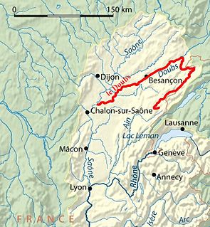
The flood of Doubs river was the biggest flooding in the history of the Doubs river (France); the water rose up to nearly 10 metres above the usual level, January 21, 1910. The principal departements affected were the département of Doubs, the département of Jura and also the département of Saône et Loire. At least one person was killed, and many others may have been killed because of this flood.

The 3rd constituency of Doubs is one of five electoral districts in the department of the same name, each of which returns one deputy to the French National Assembly in elections using the two-round system, with a run-off if no candidate receives more than 50% of the vote in the first round.
The canton of Octeville-sur-Mer is an administrative division of the Seine-Maritime department, in northern France. It was created at the French canton reorganisation which came into effect in March 2015. Its seat is in Octeville-sur-Mer.
The canton of Bretteville-l'Orgueilleuse is an administrative division of the Calvados department, northwestern France. It was created at the French canton reorganisation which came into effect in March 2015. Its seat is in Thue et Mue.
The canton of Gaillon is an administrative division of the Eure department, northern France. Its borders were modified at the French canton reorganisation which came into effect in March 2015. Its seat is in Gaillon.
The canton of Arnay-le-Duc is an administrative division of the Côte-d'Or department, eastern France. Its borders were modified at the French canton reorganisation which came into effect in March 2015. Its seat is in Arnay-le-Duc.
The canton of Saint-Vit is an administrative division of the Doubs department, eastern France. It was created at the French canton reorganisation which came into effect in March 2015. Its seat is in Saint-Vit.
The canton of Valdahon is an administrative division of the Doubs department, eastern France. It was created at the French canton reorganisation which came into effect in March 2015. Its seat is in Valdahon.
The canton of Baume-les-Dames is an administrative division of the Doubs department, eastern France. Its borders were modified at the French canton reorganisation which came into effect in March 2015. Its seat is in Baume-les-Dames.
The canton of Le Perche is an administrative division of the Loir-et-Cher department, central France. It was created at the French canton reorganisation which came into effect in March 2015. Its seat is in Savigny-sur-Braye.
The canton of Chablis is an administrative division of the Yonne department, central France. Its borders were modified at the French canton reorganisation which came into effect in March 2015. Its seat is in Chablis.
References
Coordinates: 47°29′N6°44′E / 47.49°N 6.73°E
| This Doubs geographical article is a stub. You can help Wikipedia by expanding it. |