Related Research Articles
Fontenay can refer to:
The following is a list of the 21 cantons of the Yonne department, in France, following the French canton reorganisation which came into effect in March 2015:
The following is a list of the 23 cantons of the Seine-et-Marne department, in France, following the French canton reorganisation which came into effect in March 2015:

The arrondissement of Palaiseau is an arrondissement of France in the Essonne department in the Île-de-France region. It has 68 communes. Its population is 620,608 (2016), and its area is 484.0 km2 (186.9 sq mi).

The arrondissement of Soissons is an arrondissement of France in the Aisne department in the Hauts-de-France region. It has 166 communes. Its population is 107,744 (2016), and its area is 1,342.3 km2 (518.3 sq mi).

The arrondissement of Charolles is an arrondissement of France in the Saône-et-Loire department in the Bourgogne-Franche-Comté region. It has 126 communes. Its population is 87,416 (2016), and its area is 2,443.8 km2 (943.6 sq mi).
The arrondissement of Auxerre is an arrondissement of France in the Yonne department in the Bourgogne-Franche-Comté region. It has 170 communes. Its population is 165,987 (2016), and its area is 3,431.8 km2 (1,325.0 sq mi).

The arrondissement of Avallon is an arrondissement of France in the Yonne department in the Bourgogne-Franche-Comté region. It has 135 communes. Its population is 43,189 (2016), and its area is 2,078.8 km2 (802.6 sq mi).

The Cure is a 113 km (70 mi) long river in central France, a right-bank tributary of the Yonne. Its source is in Gien-sur-Cure, in the Morvan hills. It flows into the Yonne at Cravant near Vermenton.
The canton of Villers-Cotterêts is an administrative division in northern France. At the French canton reorganisation which came into effect in March 2015, the canton was expanded from 20 to 76 communes:

Morvan Regional Natural Park is a protected area of woodlands, lakes and traditional farmland in the Bourgogne-Franche-Comté region of central France. It covers a total area of 285,000 hectares and extends through four different departments with the majority being in Nièvre. The area was officially designated as a regional natural park in 1970.
The canton of Levroux is an administrative division of the Indre department, central France. Its borders were modified at the French canton reorganisation which came into effect in March 2015. Its seat is in Levroux.
The canton of Argonne Suippe et Vesle is an administrative division of the Marne department, northeastern France. It was created at the French canton reorganisation which came into effect in March 2015. Its seat is in Sainte-Menehould.
The canton of Dormans-Paysages de Champagne is an administrative division of the Marne department, northeastern France. It was created at the French canton reorganisation which came into effect in March 2015. Its seat is in Dormans.
The canton of Charolles is an administrative division of the Saône-et-Loire department, eastern France. Its borders were modified at the French canton reorganisation which came into effect in March 2015. Its seat is in Charolles.
The canton of Loué is an administrative division of the Sarthe department, northwestern France. Its borders were modified at the French canton reorganisation which came into effect in March 2015. Its seat is in Loué.
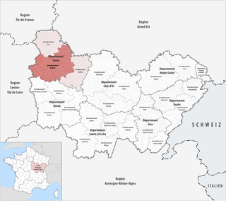
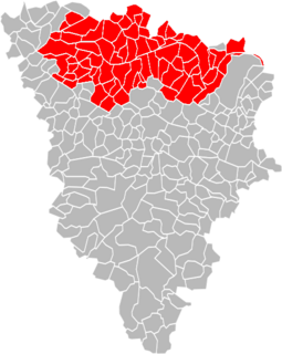
The canton of Avallon is an administrative division of the Yonne department, central France. Its borders were modified at the French canton reorganisation which came into effect in March 2015. Its seat is in Avallon.
The canton of Chablis is an administrative division of the Yonne department, central France. Its borders were modified at the French canton reorganisation which came into effect in March 2015. Its seat is in Chablis.
The Communauté urbaine Grand Paris Seine et Oise is the communauté urbaine, an intercommunal structure, covering the western suburbs of Paris. It is located in the Yvelines department, in the Île-de-France region, northern France. It was created in January 2016 by the merger of the previous communautés d'agglomération Mantes-en-Yvelines, Deux Rives de la Seine, Poissy-Achères-Conflans-Sainte-Honorine, Seine & Vexin and the communautés de communes Coteaux du Vexin and Seine-Mauldre. Its population was 411,100 in 2014. Its seat is in Aubergenville.
References
Coordinates: 47°37′N3°52′E / 47.62°N 3.86°E
| | This Yonne geographical article is a stub. You can help Wikipedia by expanding it. |