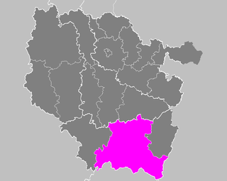
The arrondissement of Lunéville is an arrondissement of France in the Meurthe-et-Moselle department in the Grand Est region. It has 164 communes.

The arrondissement of Nancy is an arrondissement of France in the Meurthe-et-Moselle department in the Grand Est region. It has 188 communes.
The arrondissement of Épinal is an arrondissement of France in the Vosges department in the Grand Est region. It has 214 communes. In 2013 it lost the two cantons of Darney and Monthureux-sur-Saône to the arrondissement of Neufchâteau.

The following is a list of the 23 cantons of the Meurthe-et-Moselle department, in France, following the French canton reorganisation which came into effect in March 2015:
The Canton of Charmes is a French administrative and electoral grouping of communes in the Vosges département of eastern France and in the region of Grand Est. The canton has its administrative centre at Charmes.

The Mortagne is a 74.6-kilometre (46.4 mi) long river in the Vosges and Meurthe-et-Moselle départements, northeastern France. Its source is at Saint-Léonard, 5 km (3.1 mi) west of the village, in the Vosges Mountains. It flows generally northwest. It is a left tributary of the Meurthe into which it flows at Mont-sur-Meurthe, 5 km (3.1 mi) southwest of Lunéville.
The canton of Saint-Dié-des-Vosges-2 is an administrative division of the Vosges department, in northeastern France. It was created at the French canton reorganisation which came into effect in March 2015. Its seat is in Saint-Dié-des-Vosges.
The canton of Baccarat is an administrative division of the Meurthe-et-Moselle department, northeastern France. Its borders were modified at the French canton reorganisation which came into effect in March 2015. Its seat is in Baccarat.
The canton of Entre Seille et Meurthe is an administrative division of the Meurthe-et-Moselle department, northeastern France. It was created at the French canton reorganisation which came into effect in March 2015. Its seat is in Dieulouard.
The canton of Grand Couronné is an administrative division of the Meurthe-et-Moselle department, northeastern France. It was created at the French canton reorganisation which came into effect in March 2015. Its seat is in Laneuveville-devant-Nancy.
The canton of Jarny is an administrative division of the Meurthe-et-Moselle department, northeastern France. It was created at the French canton reorganisation which came into effect in March 2015. Its seat is in Jarny.
The canton of Pont-à-Mousson is an administrative division of the Meurthe-et-Moselle department, northeastern France. Its borders were modified at the French canton reorganisation which came into effect in March 2015. Its seat is in Pont-à-Mousson.
The canton of Jarville-la-Malgrange is an administrative division of the Meurthe-et-Moselle department, northeastern France. Its borders were modified at the French canton reorganisation which came into effect in March 2015. Its seat is in Jarville-la-Malgrange.
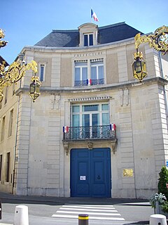
The canton of Lunéville-1 is an administrative division of the Meurthe-et-Moselle department, northeastern France. It was created at the French canton reorganisation which came into effect in March 2015. Its seat is in Lunéville.
The canton of Meine au Saintois is an administrative division of the Meurthe-et-Moselle department, northeastern France. It was created at the French canton reorganisation which came into effect in March 2015. Its seat is in Vézelise.
The canton of Toul is an administrative division of the Meurthe-et-Moselle department, northeastern France. It was created at the French canton reorganisation which came into effect in March 2015. Its seat is in Toul.
The canton of Mont-Saint-Martin is an administrative division of the Meurthe-et-Moselle department, northeastern France. Its borders were modified at the French canton reorganisation which came into effect in March 2015. Its seat is in Mont-Saint-Martin.
The canton of Neuves-Maisons is an administrative division of the Meurthe-et-Moselle department, northeastern France. Its borders were modified at the French canton reorganisation which came into effect in March 2015. Its seat is in Neuves-Maisons.
The canton of Le Nord-Toulois is an administrative division of the Meurthe-et-Moselle department, northeastern France. It was created at the French canton reorganisation which came into effect in March 2015. Its seat is in Liverdun.
The canton of Saint-Max is an administrative division of the Meurthe-et-Moselle department, northeastern France. Its borders were modified at the French canton reorganisation which came into effect in March 2015. Its seat is in Saint-Max.