Related Research Articles

Moustiers-Sainte-Marie, or simply Moustiers, is a commune in the Alpes-de-Haute-Provence department in the Provence-Alpes-Côte d'Azur region of Southeastern France. In 2017, it had a population of 709. It considered one of the "most beautiful villages of France".

The arrondissement of Digne-les-Bains is an arrondissement of France in the Alpes-de-Haute-Provence department in the Provence-Alpes-Côte d'Azur region. It has had 46 communes. Its population is 47,298 (2016), and its area is 1,574.0 km2 (607.7 sq mi).

The arrondissement of Forcalquier is an arrondissement of France in the Alpes-de-Haute-Provence department in the Provence-Alpes-Côte d'Azur region. It has 97 communes. Its population is 95,990 (2016), and its area is 2,605.4 km2 (1,006.0 sq mi).
The canton of Allos-Colmars is a former administrative division in southeastern France. It was disbanded following the French canton reorganisation which came into effect in March 2015. It consisted of 6 communes, which joined the canton of Castellane in 2015. It had 2,097 inhabitants (2012).
The canton of Annot is a former administrative division in southeastern France. It was disbanded following the French canton reorganisation which came into effect in March 2015. It consisted of 7 communes, which joined the canton of Castellane in 2015. It had 1,872 inhabitants (2012).

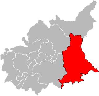
The canton of Castellane is an administrative division in southeastern France. At the French canton reorganisation which came into effect in March 2015, the canton was expanded from 7 to 32 communes. Its seat is in Castellane.
The canton of Entrevaux is a former administrative division in southeastern France. It was disbanded following the French canton reorganisation which came into effect in March 2015. It consisted of 6 communes, which joined the canton of Castellane in 2015. It had 1,418 inhabitants (2012).
The canton of Saint-André-les-Alpes is a former administrative division in southeastern France. It was disbanded following the French canton reorganisation which came into effect in March 2015. It consisted of 6 communes, which joined the canton of Castellane in 2015. It had 1,778 inhabitants (2012).
The canton of Barrême is a former administrative division in southeastern France. It was disbanded following the French canton reorganisation which came into effect in March 2015. It consisted of 8 communes, which joined the canton of Riez in 2015. It had 1,270 inhabitants (2012).
The canton of La Javie is a former administrative division in southeastern France. It was disbanded following the French canton reorganisation which came into effect in March 2015. It consisted of 6 communes, which joined the canton of Seyne in 2015. It had 1,805 inhabitants (2012).
The canton of Mézel is a former administrative division in southeastern France. It was disbanded following the French canton reorganisation which came into effect in March 2015. It consisted of 8 communes, which joined the canton of Riez in 2015. It had 2,194 inhabitants (2012).
The canton of Riez is an administrative division in southeastern France. At the French canton reorganisation which came into effect in March 2015, the canton was expanded from 9 to 26 communes:
The canton of Valensole is an administrative division in southeastern France. At the French canton reorganisation which came into effect in March 2015, the canton was expanded from 4 to 10 communes:
The canton of Banon is a former administrative division in southeastern France. It was disbanded following the French canton reorganisation which came into effect in March 2015. It consisted of 9 communes, which joined the canton of Reillanne in 2015. It had 2,989 inhabitants (2012).
The canton of Manosque-3 is an administrative division in southeastern France. It consists of the southern part of the commune of Manosque and its southern suburbs. It includes the following communes:
The canton of Reillanne is an administrative division in southeastern France. At the French canton reorganisation which came into effect in March 2015, the canton was expanded from 8 to 21 communes:
The canton of Rosans is a former administrative division in southeastern France. It was disbanded following the French canton reorganisation which came into effect in March 2015. It consisted of 7 communes, which joined the canton of Serres in 2015. It had 1,134 inhabitants (2012).

Alpes-de-Haute-Provence or sometimes abbreviated as AHP is a department in the Provence-Alpes-Côte d'Azur region of France, bordering Alpes-Maritimes and Italy to the east, Var to the south, Vaucluse to the west, Drôme and Hautes-Alpes to the north. Formerly part of the province of Provence, it had a population of 161,588 in 2016, which makes it the 94th most populated French department.
The canton of Oraison is an administrative division of the Alpes-de-Haute-Provence department, in southeastern France. It was created at the French canton reorganisation which came into effect in March 2015. Its seat is in Oraison.

The Communauté d'agglomération Provence-Alpes or Provence-Alpes Agglomération is a French agglomeration community, created on 21 October, 2016, located in the department of Alpes-de-Haute-Provence, in region Provence-Alpes-Côte d'Azur.
References
Coordinates: 43°50′54″N6°13′19″E / 43.84833°N 6.22194°E