Celles-sur-Durolle is a commune in the Puy-de-Dôme department in Auvergne-Rhône-Alpes in central France.
The arrondissement of Ambert is an arrondissement of France in the Puy-de-Dôme department in the Auvergne-Rhône-Alpes region. Since the January 2017 reorganization of the arrondissements of Puy-de-Dôme, it has 58 communes.
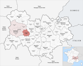
The arrondissement of Clermont-Ferrand is an arrondissement of France in the Puy-de-Dôme department in the Auvergne-Rhône-Alpes region. Since the January 2017 reorganization of the arrondissements of Puy-de-Dôme, it has 75 communes.

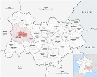
The Arrondissement of Issoire is an arrondissement of France in the Puy-de-Dôme department in the Auvergne-Rhône-Alpes region. Since the January 2017 reorganization of the arrondissements of Puy-de-Dôme, it has 135 communes.
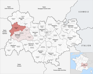
The arrondissement of Riom is an arrondissement of France in the Puy-de-Dôme department in the Auvergne-Rhône-Alpes region. Since the January 2017 reorganization of the arrondissements of Puy-de-Dôme, it has 155 communes.
The following is a list of the 31 cantons of the Puy-de-Dôme department, in France, following the French canton reorganisation which came into effect in March 2015:
Espinasse is a commune in the Puy-de-Dôme department in Auvergne in central France. Small farming village in the Pays of Combrailles, in the canton of Saint-Éloy-les-Mines, the village is nestled in a hollow, about nine kilometers west of the town of Saint-Gervais-d'Auvergne. The inhabitants of the commune are known as Espinassois or Espinassoises.
The mines of Saint-Éloy-les-Mines are coal and silver-lead mines located in the town of Saint-Éloy-les-Mines, France and environs. They were constructed in the 18th century during the beginning of industrialization in Combraille, which included:
The canton of Guéret-2 is an administrative division of the Creuse department, in central France. It was created at the French canton reorganisation which came into effect in March 2015. Its seat is in Guéret.
The canton of Le Réolais et Les Bastides is an administrative division of the Gironde department, southwestern France. It was created at the French canton reorganisation which came into effect in March 2015. Its seat is in Pineuilh.
The canton of Aigueperse is an administrative division of the Puy-de-Dôme department, central France. Its borders were modified at the French canton reorganisation which came into effect in March 2015. Its seat is in Aigueperse.
The canton of Brassac-les-Mines is an administrative division of the Puy-de-Dôme department, central France. It was created at the French canton reorganisation which came into effect in March 2015. Its seat is in Brassac-les-Mines.
The canton of Billom is an administrative division of the Puy-de-Dôme department, central France. Its borders were modified at the French canton reorganisation which came into effect in March 2015. Its seat is in Billom.
The canton of Les Monts du Livradois is an administrative division of the Puy-de-Dôme department, central France. It was created at the French canton reorganisation which came into effect in March 2015. Its seat is in Courpière.
The canton of Saint-Georges-de-Mons is an administrative division of the Puy-de-Dôme department, central France. It was created at the French canton reorganisation which came into effect in March 2015. Its seat is in Saint-Georges-de-Mons.
The canton of Saint-Ours is an administrative division of the Puy-de-Dôme department, central France. It was created at the French canton reorganisation which came into effect in March 2015. Its seat is in Saint-Ours.
The canton of Le Sancy is an administrative division of the Puy-de-Dôme department, central France. It was created at the French canton reorganisation which came into effect in March 2015. Its seat is in La Bourboule.
The canton of Thiers is an administrative division of the Puy-de-Dôme department, central France. Its borders were modified at the French canton reorganisation which came into effect in March 2015. Its seat is in Thiers.
The canton of Vic-le-Comte is an administrative division of the Puy-de-Dôme department, central France. Its borders were modified at the French canton reorganisation which came into effect in March 2015. Its seat is in Vic-le-Comte.
The Communauté de communes du Pays de Saint-Éloy is a communauté de communes, an intercommunal structure, in the Puy-de-Dôme department, in the Auvergne-Rhône-Alpes region, central France. It was created in January 2017 by the merger of the former communautés de communes Cœur de Combrailles, Saint-Éloy Communauté and Pionsat, joined by 5 other communes. Its population was 16,680 in 2014. Its seat is in Saint-Éloy-les-Mines.