Georges Chometon, is a former French politician.
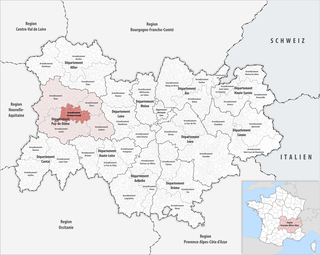
The arrondissement of Clermont-Ferrand is an arrondissement of France in the Puy-de-Dôme department in the Auvergne-Rhône-Alpes region. Since the January 2017 reorganization of the arrondissements of Puy-de-Dôme, it has 75 communes.
The following is a list of the 31 cantons of the Puy-de-Dôme department, in France, following the French canton reorganisation which came into effect in March 2015:

Royat is a commune in the Puy-de-Dôme department in Auvergne in central France.

Saint-Alyre-d'Arlanc is a commune in the Puy-de-Dôme department in Auvergne in central France.

Aubière is a French commune located in the department of Puy-de-Dôme in the Auvergne-Rhône-Alpes region in southeast France. As of 2014 its population was 9,832.

Blanzat is a commune in the Puy-de-Dôme department in Auvergne-Rhône-Alpes in central France.

Vertaizon is a commune of the department of Puy-de-Dôme in the region Auvergne-Rhône-Alpes. It is part of the urban area of Clermont-Ferrand.

The Panoramique des Dômes is a 5.2 km long rack railway that allows access to the top of the Puy de Dôme, in France, since mid-2012.
The following is a timeline of the history of the city of Clermont-Ferrand, France.
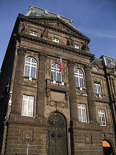
The Puy-de-Dôme General Council is the deliberative assembly of the Puy-de-Dôme department. It consists of sixty-one members and its headquarters are in Clermont-Ferrand, capital of the department, and the president is Jean-Yves Gouttebel. The general councilors are elected for a 6-years term. The Puy-de-Dôme General Council includes 15 vice-presidents. The General Council has a logo.
The canton of Beaumont is an administrative division of the Puy-de-Dôme department, central France. Its borders were not modified at the French canton reorganisation which came into effect in March 2015. Its seat is in Beaumont.
The canton of Chamalières is an administrative division of the Puy-de-Dôme department, central France. Its borders were modified at the French canton reorganisation which came into effect in March 2015. Its seat is in Chamalières.
The canton of Châtel-Guyon is an administrative division of the Puy-de-Dôme department, central France. It was created at the French canton reorganisation which came into effect in March 2015. Its seat is in Châtel-Guyon.
The canton of Gerzat is an administrative division of the Puy-de-Dôme department, central France. Its borders were modified at the French canton reorganisation which came into effect in March 2015. Its seat is in Gerzat.
The canton of Maringues is an administrative division of the Puy-de-Dôme department, central France. Its borders were modified at the French canton reorganisation which came into effect in March 2015. Its seat is in Maringues.
The canton of Orcines is an administrative division of the Puy-de-Dôme department, central France. It was created at the French canton reorganisation which came into effect in March 2015. Its seat is in Orcines.
The canton of Pont-du-Château is an administrative division of the Puy-de-Dôme department, central France. Its borders were modified at the French canton reorganisation which came into effect in March 2015. Its seat is in Pont-du-Château.
Clermont Auvergne Métropole is the métropole, an intercommunal structure, centred on the city of Clermont-Ferrand. It is located in the Puy-de-Dôme department, in the Auvergne-Rhône-Alpes region, central France. It was created in January 2018, replacing the communauté urbaine that had replaced the previous communauté d'agglomération Clermont-Communauté in January 2017. Its population was 291,813 in 2014, of which 144,760 in Clermont-Ferrand proper.