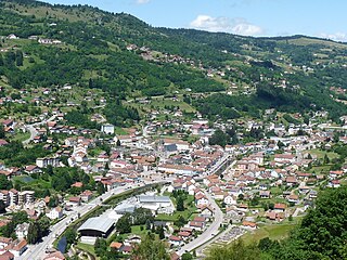
Saulxures-sur-Moselotte is a commune in the Vosges department in Grand Est in northeastern France.
The Canton of Bulgnéville is a French former administrative and electoral grouping of communes in the Vosges département of eastern France and in the region of Lorraine. It was disbanded following the French canton reorganisation which came into effect in March 2015. It consisted of 12 communes, which joined the canton of Vittel in 2015.
The Canton of Lamarche is a former French administrative and electoral grouping of communes in the Vosges département of eastern France and in the region of Lorraine. It was disbanded following the French canton reorganisation which came into effect in March 2015. It consisted of 26 communes, which joined the canton of Darney in 2015.
The Canton of Coussey is a former French administrative and electoral grouping of communes in the Vosges département of eastern France and in the region of Lorraine. It was disbanded following the French canton reorganisation which came into effect in March 2015. It consisted of 21 communes, which joined the canton of Neufchâteau in 2015.
The Canton of Monthureux-sur-Saône is a former French administrative and electoral grouping of communes in the Vosges département of eastern France and in the region of Lorraine. It was disbanded following the French canton reorganisation which came into effect in March 2015. It consisted of 11 communes, which joined the canton of Darney in 2015.
The Canton of Bruyères is a largely rural French administrative and electoral grouping of communes in the Vosges département of eastern France and in the region of Grand Est. The canton has its administrative centre at Bruyères.
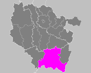
The Canton of Le Thillot is a French administrative and electoral grouping of communes in the Vosges département of eastern France and in the region of Grand Est.
The Canton of Vittel is a French administrative and electoral grouping of communes in the Vosges département of eastern France and in the region of Grand Est. The Canton of Vittel has its administrative centre at Vittel.
The Canton of Neufchâteau is a rural French administrative and electoral grouping of communes in the Vosges département of eastern France and in the region of Grand Est. The canton has its administrative centre at Neufchâteau.
The Canton of Brouvelieures is a former French administrative and electoral grouping of communes in the Vosges département of eastern France and in the region of Lorraine. It was disbanded following the French canton reorganisation which came into effect in March 2015. It consisted of 10 communes, which joined the canton of Bruyères in 2015.
The Canton of Provenchères-sur-Fave is a former French administrative and electoral grouping of communes in the Vosges département of eastern France and in the region of Lorraine. It was disbanded following the French canton reorganisation which came into effect in March 2015. It consisted of 7 communes, which joined the canton of Saint-Dié-des-Vosges-2 in 2015.
The Canton of Plombières-les-Bains is a French former administrative and electoral grouping of communes in the Vosges département of eastern France and in the region of Lorraine. It was disbanded following the French canton reorganisation which came into effect in March 2015. It consisted of 4 communes, which joined the canton of Le Val-d'Ajol in 2015.

The Moselotte is a river in Lorraine, in the French department of Vosges. It is a direct right tributary of the Moselle, and thus a sub-tributary of the Rhine.
The Communauté de communes des Hautes Vosges is an administrative association of rural communes in the Vosges department of eastern France. It was created on 1 January 2017 by the merger of the former Communauté de communes de Gérardmer-Monts et Vallées, Communauté de communes de la Haute Moselotte and Communauté de communes Terre de Granite. It consists of 22 communes, and has its administrative offices at Gérardmer.
The canton of La Bresse is an administrative division of the Vosges department, in northeastern France. It was created at the French canton reorganisation which came into effect in March 2015. Its seat is in La Bresse.
The canton of Gérardmer is an administrative division of the Vosges department, in northeastern France. At the French canton reorganisation which came into effect in March 2015, it was expanded from 3 to 17 communes. Its seat is in Gérardmer.
The canton of Bourbonne-les-Bains is an administrative division of the Haute-Marne department, northeastern France. Its borders were modified at the French canton reorganisation which came into effect in March 2015. Its seat is in Bourbonne-les-Bains.
The canton of Pierre-de-Bresse is an administrative division of the Saône-et-Loire department, eastern France. Its borders were modified at the French canton reorganisation which came into effect in March 2015. Its seat is in Pierre-de-Bresse.