
Haut-Rhin is a department in the Grand Est region of France, named after the river Rhine. Its name means Upper Rhine. Haut-Rhin is the smaller and less populated of the two departments of the former administrative Alsace region, especially after the 1871 cession of the southern territory known since 1922 as Territoire de Belfort, although it is still densely populated compared to the rest of metropolitan France.

The administrative divisions of France are concerned with the institutional and territorial organization of French territory. These territories are located in many parts of the world. There are many administrative divisions, which may have political, electoral (districts), or administrative objectives. All the inhabited territories are represented in the National Assembly, Senate and Economic and Social Council and their citizens have French citizenship.

The following is a list of the 102 communes of the Territoire de Belfort department of France.
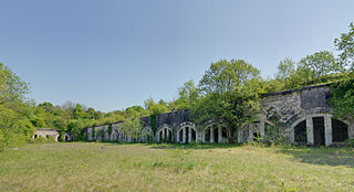
The arrondissement of Belfort is an arrondissement in the Bourgogne-Franche-Comté region of France. It is the only arrondissement located in the Territoire de Belfort department. It has 9 cantons and 102 communes.
The following is a list of the 9 cantons of the Territoire de Belfort department, in France, following the French canton reorganisation which came into effect in March 2015:
Bermont is a commune in the Territoire de Belfort department in Bourgogne-Franche-Comté in northeastern France.

Riervescemont is a commune in the Territoire de Belfort department in Bourgogne-Franche-Comté in northeastern France.

Gare de Belfort is the railway station serving the town Belfort, Territoire de Belfort department, eastern France. It is situated on the Paris–Mulhouse railway.
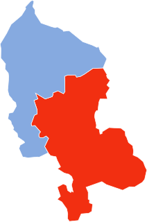
Territoire de Belfort's 1st constituency is one of two French legislative constituencies in the department of Territoire de Belfort. It is currently represented by Ian Boucard of The Republicans (LR).

Bourgogne-Franche-Comté is a region of France created by the territorial reform of French Regions in 2014, from a merger of Burgundy and Franche-Comté. The new region came into existence on 1 January 2016, after the regional elections of December 2015, electing 100 members to the regional council of Bourgogne-Franche-Comté.
The canton of Bavilliers is an administrative division of the Territoire de Belfort department, northeastern France. It was created at the French canton reorganisation which came into effect in March 2015. Its seat is in Bavilliers.
The canton of Châtenois-les-Forges is an administrative division of the Territoire de Belfort department, northeastern France. Its borders were modified at the French canton reorganisation which came into effect in March 2015. Its seat is in Châtenois-les-Forges.
The canton of Delle is an administrative division of the Territoire de Belfort department, northeastern France. Its borders were modified at the French canton reorganisation which came into effect in March 2015. Its seat is in Delle.
The canton of Giromagny is an administrative division of the Territoire de Belfort department, northeastern France. Its borders were modified at the French canton reorganisation which came into effect in March 2015. Its seat is in Giromagny.
The canton of Grandvillars is an administrative division of the Territoire de Belfort department, northeastern France. Its borders were modified at the French canton reorganisation which came into effect in March 2015. Its seat is in Grandvillars.
The canton of Valdoie is an administrative division of the Territoire de Belfort department, northeastern France. Its borders were modified at the French canton reorganisation which came into effect in March 2015. Its seat is in Valdoie.

Ian Boucard is a French politician who served as deputy for Territoire de Belfort's 1st constituency from June to December 2017, with the invalidation of his election triggering a by-election in early 2018 in which he was re-elected. He is a member of The Republicans.
