History
The Canutama Extractive Reserve was created by Amazonas state decree 28421 of 27 March 2009. The conservation unit was created with five others totalling 23,000 square kilometres (8,900 sq mi) to help meet the requirements for granting an environmental license to reconstruction work on the BR-319 highway that connects Porto Velho to Manaus. The minister of the environment defended implementation of what he called a "green pocket" around the highway. On 16 November 2009 the Instituto Nacional de Colonização e Reforma Agrária (INCRA – National Institute for Colonization and Agrarian Reform) recognised the reserve as supporting 200 families who would be eligible for PRONAF.
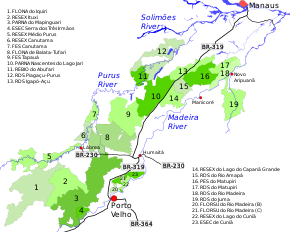
The state-level conservation units in the BR-319 corridor are the Piagaçu-Purus, Rio Amapá, Rio Madeira, Igapó-Açu and Matupiri sustainable development reserves, Canutama Extractive Reserve, Canutama State Forest, Tapauá State Forest and Matupiri State Park. In December 2012 the Amazonas state government allocated more than R$6 million to these nine units, covering 30,000 square kilometres (12,000 sq mi) and 143 communities, to be coordinated by the State Center for Conservation Units (CEUC). The funding was for development of management plans, creation of management councils, environmental monitoring, land survey, and production and marketing.
The management plan was approved on 22 July 2014. As of 2016 the reserve was supported by the Amazon Region Protected Areas Program.

Jutaí is a municipality located in the Brazilian state of Amazonas. Its population is 13,886 (2020) and its area is 69,552 km2, making it the fifth largest municipality in Amazonas by area and the ninth largest in Brazil.
Nascentes do Lago Jari National Park is a national park in the state of Amazonas, Brazil. It protects an area of Amazon rainforest in the BR-319 highway area of influence.

Mapinguari National Park is a national park in the states of Rondônia and Amazonas, Brazil. It covers a large area of Amazon rainforest. The boundaries have been adjusted several times.

The Médio Juruá Extractive Reserve is an extractive reserve in the state of Amazonas Brazil.
The Guariba Extractive Reserve is an extractive reserve in the state of Amazonas, Brazil.

The Rio Ouro Preto Extractive Reserve is an extractive reserve in the state of Rondônia, Brazil. Created in 1990, it was one of the first such reserves in Brazil. The residents extract rubber, nuts and other products in the dry season and farm or work outside the reserve in the rainy season, when large areas are flooded. Houses are built on stilts to avoid flooding and discourage animals from entering.
The Lago do Capanã Grande Extractive Reserve is an extractive reserve in the state of Amazonas.

The Ituxi Extractive Reserve is an extractive reserve in the state of Amazonas, Brazil.
Matupiri State Park is a state park in the state of Amazonas, Brazil. It protects a rich area of Amazon rainforest and an ecologically important area of woodland savanna along the Matupiri River. Unusually for a state park, it includes an "indigenous special use zone" that allows the Mura people to continue to fish and extract forest products, as they have for many generations.
The Matupiri Sustainable Development Reserve is a sustainable development reserve in the state of Amazonas, Brazil.
The Rio Amapá Sustainable Development Reserve (Portuguese: Reserva de Desenvolvimento Sustentável do Rio Amapá is a sustainable development reserve in the state of Amazonas, Brazil.
The Igapó-Açu Sustainable Development Reserve is a sustainable development reserve in the state of Amazonas, Brazil. It is part of a "green barrier" created to prevent deforestation along the BR-319 highway.
The Canutama State Forest is a state forest in the state of Amazonas, Brazil.
The Tapauá State Forest is a state forest in the state of Amazonas, Brazil.
The Médio Purus Extractive Reserve is an extractive reserve in the state of Amazonas, Brazil.
The Lago do Cuniã Extractive Reserve is an extractive reserve in the state of Rondônia, Brazil.
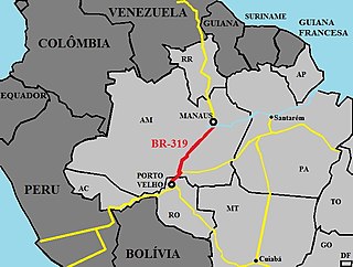
BR-319 is an 870-kilometre (540 mi) federal highway that links Manaus, Amazonas to Porto Velho, Rondônia. The highway runs through a pristine part of the Amazon rainforest. It was opened by the military government in 1973 but soon deteriorated, and by 1988 was impassible. In 2008 work began to repair the highway, which will provide an alternative to boat travel along the Madeira River or flying between Manaus and Porto Velho. Protected areas have been created along the route in an effort to prevent deforestation when BR-319 is reopened, a serious concern given the devastation caused elsewhere by highways such as BR-364. As of mid-2016 paving of the middle section of the highway had yet to be approved. Construction permits will depend on measures to prevent future damage to the forest.
The Arapixi Extractive Reserve is an extractive reserve in the state of Amazonas, Brazil.
The Rio Unini Extractive Reserve is an extractive reserve in the state of Amazonas, Brazil.
The Baixo Juruá Extractive Reserve is an extractive reserve in the state of Amazonas, Brazil. It contains an area of almost untouched Amazon rainforest inhabited by communities that rely on manioc farming, small-scale animal husbandry, fishing, hunting and gathering.
This page is based on this
Wikipedia article Text is available under the
CC BY-SA 4.0 license; additional terms may apply.
Images, videos and audio are available under their respective licenses.