| Canyon Dam | |
|---|---|
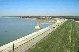
 A view of Canyon Dam from the south | |
| Country | the United States |
| Location | on the Guadalupe River |
The Canyon Dam in Texas is a rolled-earth dam on the Guadalupe River in the Hill Country. The water impounded by the dam forms Canyon Lake.
| Canyon Dam | |
|---|---|
| A view of Canyon Dam from the south | |
| Country | the United States |
| Location | on the Guadalupe River |
The Canyon Dam in Texas is a rolled-earth dam on the Guadalupe River in the Hill Country. The water impounded by the dam forms Canyon Lake.
Canyon Dam is located 36 miles (58 km) northeast of San Antonio and 38 miles (61 km) southwest of Austin.
The dam is 6,830 feet (2,080 m) long, across a narrow section of the Guadalupe River valley. The top of the dam is 974 feet (297 m) above sea level, or 224 feet (68 m) above the riverbed. A spillway, located south of the dam, protects the dam by releasing water when the lake level rises to 943 feet (287 m) above sea level.
The dam is located near the Balcones Escarpment. The rocky canyons to the west of the escarpment can carry more water than the riverbeds of the plains to the east; this has caused problems with flash flooding in cities and towns east of the escarpment.
After major floods on the Guadalupe River in 1936 and 1938, state and community leaders pressured the federal government to help control flooding of the river. Congress authorized initial funds for construction of a dam in the Rivers and Harbors Act of 1945; final construction approval came in the Flood Control Act of 1954.
Construction of Canyon Dam began in 1958 to provide both flood control and water conservation. Impoundment of the lake began in 1964, and the lake was filled to its conservation level in 1968. The dam was built by the Tencon Corporation of Fort Worth, Texas. The United States Army Corps of Engineers controls the physical operations; and water in the lake is managed by the Guadalupe-Blanco River Authority.

Lake Travis is a reservoir on the Colorado River in central Texas in the United States. It is named in honor of William B. Travis.

Detroit Lake is a reservoir impounded by the Detroit Dam on the North Santiam River 46 miles (74 km) southeast of Salem, Oregon, United States. The lake is adjacent to Oregon Route 22 near the city of Detroit. This mesotrophic lake stores water for use by the city of Salem and other nearby communities.

Seven Oaks Dam is a 550-foot (170 m) high earth and rock fill embankment dam across the Santa Ana River in the San Bernardino Mountains, about 4 miles (6.4 km) northeast of Redlands in San Bernardino County, southern California. It impounds Seven Oaks Reservoir in the San Bernardino National Forest.

The Guadalupe River runs from Kerr County, Texas, to San Antonio Bay on the Gulf of Mexico, with an average temperature of 17.75 degrees Celsius. It is a popular destination for rafting, fly fishing, and canoeing. Larger cities along it include Kerrville, New Braunfels, Seguin, Gonzales, Cuero, and Victoria. It has several dams along its length, the most notable of which, Canyon Dam, forms Canyon Lake northwest of New Braunfels.

Table Rock Lake is an artificial lake or reservoir in the Ozarks of southwestern Missouri and northwestern Arkansas in the United States. Designed, built and operated by the U.S. Army Corps of Engineers, the lake is impounded by Table Rock Dam, which was constructed from 1954 to 1958 on the White River.

Dworshak Dam is a concrete gravity dam in the western United States, on the North Fork of the Clearwater River in north central Idaho. In Clearwater County, the dam is located approximately four miles (6 km) northwest of Orofino and impounds the Dworshak Reservoir for flood control and hydroelectricity generation. By capacity, the reservoir is the largest in Idaho and fourth-largest in the Pacific Northwest.

Canyon Lake is a reservoir on the Guadalupe River in the Texas Hill Country in the United States. Canyon Lake is a U.S. Army Corps of Engineers reservoir formed on the Guadalupe River in Comal County by Canyon Dam, which is located about sixteen miles northwest of New Braunfels. The dam, lake, and all adjacent property are managed by the U.S. Army Corps Of Engineers. Water rights, waste water treatment, and hydroelectric generating facilities are managed by the Guadalupe-Blanco River Authority. Construction of the dam began in 1958 and was completed in 1964. The reservoir serves to provide flood control and water supply for the communities downstream from the dam. The lake is also a popular recreational destination.

Wright Patman Lake is a reservoir in northeast Texas in the United States. The lake is a U.S. Army Corps of Engineers reservoir formed on the Sulphur River in Bowie and Cass counties by Wright Patman Dam. The reservoir provides flood control and water conservation for the communities downstream from the dam. The lake is also a popular recreational destination. The Bowie County side of the lake is part of the Texarkana metropolitan area.
Wright Patman Dam is an earth-fill dam across the Sulphur River in northeast Texas in the United States. The water impounded by the dam forms Wright Patman Lake.

Lavon Lake is a freshwater reservoir located in southeast Collin County, Texas, on the East Fork of the Trinity River near Wylie, off State Highway 78. It is commonly called Lake Lavon for commercial and recreational purposes, but Lavon Lake is its official name according to the U.S. Army Corps of Engineers. It was originally called Lavon Reservoir.
Grapevine Lake is a reservoir in North Texas about 20 mi (32 km) northwest of Dallas and northeast of Fort Worth. It was impounded in 1952 by the U.S. Army Corps of Engineers when they dammed Denton Creek, a tributary of Trinity River.

Lake O’ the Pines is a reservoir on Big Cypress Bayou, also known as Big Cypress Creek, chiefly in Marion County, Texas, United States. The reservoir also occupies a small part of Camp, Upshur, and Morris Counties. The dam is located approximately 8.5 miles (13.7 km) west of Jefferson.

Benbrook Lake is a reservoir on the Clear Fork of the Trinity River in Tarrant County, Texas, USA. The lake is located approximately 10 miles (16 km) southwest of the center of Fort Worth, where the Clear Fork and the West Fork of the Trinity River join. The lake is impounded by the Benbrook Dam. The lake and dam are owned and operated by the U.S. Army Corps of Engineers, Fort Worth District.

Lost Creek Lake is a reservoir located on the Rogue River in Jackson County, Oregon, United States. The lake is impounded by William L. Jess Dam which was constructed by the U.S. Army Corps of Engineers in 1977 for flood control and fisheries enhancement. The lake and dam were the first completed elements of the multi-purpose Rogue River Basin Project, consisting of Lost Creek Lake, Applegate Lake and the Elk Creek project. The lake is located approximately 27 miles (43 km) northeast of Medford.
The Chelan River is a tributary of the Columbia River, in the U.S. state of Washington. Just 4.1 miles (6.6 km) long, it is the shortest river in Washington. Lake Chelan Dam is located at the river's source: the outlet of Lake Chelan. Nearly the entire river's flow is diverted to the Lake Chelan Powerhouse, 3.9 miles (6.3 km) downstream near the river's mouth. Thus the Chelan River is almost always dry. Statistics on the streamflow are taken at the tailrace of the powerhouse, measuring the water that would flow through the river were it not diverted, although not including small tributaries, including Daybreak Canyon, that join the Chelan riverbed from the Lake Chelan Dam to the canal outlet.

Canyon Lake Gorge is a limestone gorge in Texas, which is around 1 mile (1.6 km) long, hundreds of yards (metres) wide, and up to 50 feet (15 m) or more deep, which was exposed in 2002 when extensive flooding of the Guadalupe River led to a huge amount of water going over the spillway from Canyon Lake reservoir and removing the sediment from the gorge. The gorge provides a valuable exposure of rock strata as old as 111 million years showing fossils and a set of dinosaur tracks, and forms a new ecosystem for wildlife with carp and other creatures in a series of pools fed by springs and waterfalls.

John Redmond Reservoir is a reservoir on the Neosho River in eastern Kansas. Built and managed by the U.S. Army Corps of Engineers, it is used for flood control, recreation, water supply, and wildlife management. It borders the Flint Hills National Wildlife Refuge to the northwest.
Pine Creek Lake is a lake in McCurtain County and Pushmataha County, Oklahoma, USA. It is 8 miles (13 km) north of Valliant, Oklahoma. It is located east of Rattan and north of Sobol.

Santa Fe Dam is a flood-control dam on the San Gabriel River located in Irwindale in Los Angeles County, California, United States. For most of the year, the 92-foot (28 m)-high dam and its reservoir lie empty, but can hold more than 45,000 acre-feet (56,000,000 m3) of water during major storms. During the dry season, the basin behind the dam is used for groundwater recharge, as well as various recreational activities.

Kanopolis Lake is a reservoir in Ellsworth County in the Smoky Hills of central Kansas, about 31 miles southwest of Salina and a few miles southeast of the town of Kanopolis. The lake is formed by Kanopolis Dam. Completed in 1948 as a flood control and water conservation project of the United States Army Corps of Engineers, the dam impounds the Smoky Hill River.