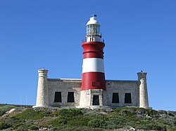
Location | L'Agulhas, Western Cape, South Africa |
---|---|
Coordinates | 34°49′46″S20°00′32″E / 34.829389°S 20.008911°E |
Tower | |
Constructed | 1848 (first lit 1849) |
Construction | sandstone tower |
Height | 27 m (89 ft) |
Shape | cylindrical tower with balcony and lantern rising from one-story keeper's house |
Markings | red tower with a white band, white lantern |
Power source | mains electricity |
Operator | South African National Parks [1] |
Light | |
First lit | 1 March 1849 |
Deactivated | 1968–1988 |
Focal height | 31 m (102 ft) |
Lens | 1st order Fresnel |
Intensity | 7,500,000 cd |
Range | 30 nmi (56 km; 35 mi) |
Characteristic | Fl W 5s |
The Cape Agulhas Lighthouse is at Cape Agulhas, the southernmost tip of Africa. At 171 years old, it is the third-built lighthouse in South Africa, and the second-oldest still operating, after Green Point. [2] It is located on the southern edge of the village of L'Agulhas, in the Agulhas National Park; the light is operated by Transnet National Ports Authority. In 2016, the American Society of Civil Engineers (ASCE) identified the lighthouse as a deserving prominent historic engineering project and International Historic Civil Engineering Landmark.
A lighthouse at Cape Agulhas was suggested by Colonel Charles Collier Michell, the Surveyor-General of the Cape, in March 1837. A public meeting at Cape Town on 11 July 1840 resolved to raise funds for the construction of the lighthouse, and Michiel van Breda, the founder of Bredasdorp, offered to donate the land on which it was to be built. Apart from local contributions, funds were received from Bombay, Calcutta, Madras, Manila, St Helena and London; by June 1843 the sum raised was £1,479.3s.9d (£1,479.19). [3]
In 1847, the government of the Cape Colony agreed to fund the construction at a cost of £15,871; building work began in April and was completed in December 1848, and the light was first lit on 1 March 1849. Originally, it was fuelled by the tail-fat of sheep, but in 1905 an oil-burning lantern was installed. In March 1910, the lens was replaced with a first-order Fresnel lens. In 1929, the oil burner was replaced by a petroleum vapour burner, which was in turn replaced in 1936 by a four-kilowatt electric lamp powered by a diesel generator. [3]
In 1968, the lighthouse was taken out of service, and the light moved to an aluminum tower, as it was discovered that the sandstone walls were crumbling due to excessive weathering. The building was declared a national monument in 1973 and is also a Western Cape provincial heritage site. [4] Restoration and reconstruction was performed by the Bredasdorp Shipwreck Museum and the local council, and the lighthouse was recommissioned in 1988. [3] [5]
In 2016, the American Society of Civil Engineers (ASCE) identified the lighthouse as a deserving prominent historic engineering project and International Historic Civil Engineering Landmark. [6] [7]
The lighthouse consists of a round tower, 27 metres (89 ft) high and painted red with a white band, that is attached to the keeper's house, which now contains a museum and restaurant. [8] The design of the building was inspired by the Pharos of Alexandria. [5] The focal plane of the light is 31 metres (102 ft) above high water; the range of the 7.5 megacandela lantern is 30 nautical miles (56 km; 35 mi). The rotating optic gives off one white flash every five seconds. [9]
A lighthouse is a tower, building, or other type of physical structure designed to emit light from a system of lamps and lenses and to serve as a beacon for navigational aid, for maritime pilots at sea or on inland waterways.
Cape Agulhas is a rocky headland in Western Cape, South Africa. It is the geographic southern tip of Africa and the beginning of the traditional dividing line between the Atlantic and Indian Oceans according to the International Hydrographic Organization. It is approximately half a degree of latitude, or 55 kilometres (34 mi), further south than the Cape of Good Hope.
Cape Agulhas Municipality is a municipality located in the Western Cape province of South Africa. As of 2011, it had a population of 33,038. Its municipality code is WC033. It is named after Cape Agulhas, the southernmost point of Africa. The largest town is Bredasdorp, which is the seat of the municipal headquarters. It also includes the villages of Napier, Struisbaai, Elim, Arniston and L'Agulhas, and the De Hoop Nature Reserve.
L'Agulhas is the southernmost coastal village and holiday resort in South Africa, located within the Cape Agulhas Local Municipality at the southernmost tip of the African mainland. It is situated next to the town of Struisbaai and about 30 kilometres (20 mi) south of the regional centre of Bredasdorp. Some of the older residents and documents refer to the town as by its former name Cape Agulhas or Cape L'Agulhas or simply Agulhas which were the names that referred to this town before it was changed to L'Agulhas to avoid confusion when the Bredasdorp Municipality changed its name to The Cape Agulhas Municipality (CAM).
Cape Borda Lighthouse is a lighthouse in the Australian state of South Australia located at Cape Borda on Kangaroo Island.
Bredasdorp is a town in the Southern Overberg region of the Western Cape, South Africa, and the main economic and service hub of that region. It lies on the northern edge of the Agulhas Plain, about 160 kilometres (100 mi) south-east of Cape Town and 35 kilometres (22 mi) north of Cape Agulhas, the southernmost tip of Africa.
Fort Canning Lighthouse also known as Fort Canning Light is located on top of Fort Canning Hill and was formerly one of the 13 important lighthouses in the Straits of Malacca. Located nearby with The Flagstaff and the Time Ball, the three navigation structures played an essential role during the early maritime history of Singapore.
The Beach Lighthouse is a 44-foot (13 m) tall sandstone lighthouse in Fleetwood, Lancashire, England.
Plumb Point Lighthouse is an active 19th century heritage lighthouse, located on the Palisadoes a narrow peninsular that connects Port Royal to the mainland. The light helps guide shipping into Kingston Harbour.
Point Charles Light, known officially as the Charles Point Lighthouse, is an active lighthouse located on a headland at the northern end of the Cox Peninsula, 21 kilometres (13 mi) northwest of Port Darwin, Northern Territory, Australia. Established in 1893, it is the oldest lighthouse in the Northern Territory.
Booby Island Light is an active heritage-listed lighthouse located on Booby Island in the Shire of Torres, near the tip of Cape York Peninsula, west of Prince of Wales Island, within the Endeavour Strait, Queensland, Australia. It marks the western entrance to the navigation channel through the Torres Strait. It was the last of the major lights to be constructed along the Queensland coast.
Sea Hill Lighthouse, also known as Sea Hill Point Light or Little Sea Hill Light, is a lighthouse on the northwest point of Curtis Island, Gladstone Region, Queensland, Australia. Its purpose was to mark the east side of the entrance to Keppel Bay, on passage to Fitzroy River and Port Alma. The first lighthouse at the locations was constructed in 1873 or 1876, moved in the 1920s, and is now on display at the Gladstone Maritime Museum. A second lighthouse was constructed in 1895 and its state is unclear.
Cape Capricorn Light is an active heritage-listed lighthouse located on Cape Capricorn, a coastal headland on the northeast point of Curtis Island, in Gladstone Region, Central Queensland, Australia. The lighthouse, constructed in 1964, is the third at this site, following a timber frame lighthouse constructed in 1875 and a concrete lighthouse constructed around 1937. It was added to the Queensland Heritage Register on 31 August 2001.
Dent Island Light is an active lighthouse on Dent Island, a small island off the coast of Queensland, Australia, part of the Whitsunday Group of the Whitsunday Islands. Located on the southwest tip of the island, the light guides ships navigating the Whitsunday Passage, between Whitsunday Island and the islands to the west, and marks the Dent Island Passage.
Low Isles Light, also known as Low Islets Light or Low Island Light, is an active lighthouse located on Low Island, a coral cay which together with Woody Island forms the Low Isles group, about 13 kilometres (8.1 mi) northeast of Port Douglas, Queensland, Australia. The island is situated on the western edge of the main shipping channel into the harbour of Port Douglas, and it marks the entrance to the channel. Built in 1878, it was the first lighthouse in Far North Queensland and more specifically the first to light the Inner Passage of the Great Barrier Reef. Its construction is typical to Queensland lighthouses of the time, timber frame clad with galvanized iron, and it is the fourth lighthouse of this type constructed in Queensland, though it is the first of them to use portholes.
South Gare Lighthouse was built in 1884 at the end of the breakwater at South Gare north west of Redcar in North Yorkshire and in north eastern England.
Low Point Lighthouse is an historic Canadian lighthouse marking the eastern entrance to Sydney Harbour at New Victoria, Nova Scotia, near New Waterford, Nova Scotia. This is one of the earliest and most important light stations of Nova Scotia, one of the first dozen beacons in Nova Scotia to be lit to guide mariners, a classic red-and-white lighthouse still operated by the Canadian Coast Guard.
The isle of Lundy has three lighthouses: a pair of active lights built in 1897 and an older lighthouse dating from 1797.