The Cabot Trail is a scenic highway on Cape Breton Island in Nova Scotia, Canada. It is a 298 km (185 mi) loop around the northern tip of the island, passing along and through the Cape Breton Highlands and the Cape Breton Highlands National Park.

The Avalon Peninsula is a large peninsula that makes up the southeast portion of the island of Newfoundland. It is 9,220.61 square kilometres (3,560.10 sq mi) in size.

Bonavista is a town on the Bonavista Peninsula, Newfoundland in the Canadian province of Newfoundland and Labrador. Unlike many Newfoundland coastal settlements, Bonavista was built on an open plain, not in a steep cove, and thus had room to expand to its current area of 31.5 km2 (12.2 sq mi). Bonavista is located approximately 300km from the provincial capital of St. John's.

The Province of Avalon was the area around the English settlement of Ferryland in what is now Newfoundland and Labrador, Canada in the 17th century, which upon the success of the colony grew to include the land held by Sir William Vaughan and all the land that lay between Ferryland and Petty Harbour.
The Aspy River is a river on northeastern Cape Breton Island which rises in the Cape Breton Highlands and empties into Aspy Bay. The North Aspy follows the ancient Aspy Fault which extends for 40 km inland from the coast and extends along the upper section of the northeast Margaree River. This geological fault is thought to be a part of the Cabot Fault (Newfoundland)/ Great Glen Fault (Scotland) system of Avalonia.

Matthew was a caravel sailed by John Cabot in 1497 from Bristol to Newfoundland, North America. There are two modern replicas – one in Bristol, England and one in Bonavista, Newfoundland.

Grates Cove is a local service district and designated place in the Canadian province of Newfoundland and Labrador. It is the most northerly community on the Avalon Peninsula, located on the tip of the Bay de Verde Peninsula on the island of Newfoundland. Called "the Grates" by John Guy as early as 1612, the origin of the name is unknown.

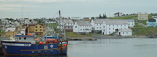
Harbour Grace is a town in Conception Bay on the Avalon Peninsula in the province of Newfoundland and Labrador, Canada. With roots dating back to the 16th century, it is one of the oldest towns in North America.
Bonavista Bay (BB) is a large bay located on the northeast coast of the island of Newfoundland in the province of Newfoundland and Labrador in Canada. It opens directly onto the Atlantic Ocean.
Cape Bauld is a headland located at the northernmost point of Quirpon Island, an island just northeast of the Great Northern Peninsula of Newfoundland in the Canadian province of Newfoundland and Labrador.
Cape St. John is a headland located on the north coast of Newfoundland in the Canadian province of Newfoundland and Labrador.

The East Coast Trail (ECT) is a long-distance coastal footpath located in the Canadian province of Newfoundland and Labrador. It is a developed trail over 336 kilometres (209 mi) long, creation of which began in 1994. It is made up of 25 linked wilderness paths and passes through more than 30 communities. It was named one of the best adventure destinations by National Geographic in 2012 and is extended and improved yearly.
The Bonavista Peninsula is a large peninsula on the east coast of the island of Newfoundland in the Canadian province of Newfoundland and Labrador. It consists of 50 incorporated towns/unincorporated communities which have a population of 12,176 as of the 2016 Canadian Census. Bonavista is the largest population centre on the peninsula.

Cape North is a headland at the northeastern end of Cape Breton Island. It is in the jurisdiction of the Municipality of the County of Victoria, Nova Scotia Canada.

Cape Freels is a headland on the island of Newfoundland, in the province of Newfoundland and Labrador, Canada, and the location of a community of the same name. This cape, located at the northern extremity of Bonavista Bay, is not to be confused with another Cape Freels which is located at the southern extremity of the Avalon Peninsula of Newfoundland.
Smith Sound is a zigzag 24 kilometre inner region of Trinity Bay. This sound is one of the longest portions of inshore waterways in Newfoundland, located on its north-eastern coast in the Canadian province of Newfoundland and Labrador. Bonavista Peninsula is to the north of the sound, while Random Island is to the south. The waters that make up the sound is a continuous channel that encircles Random Island, broken only by a narrow channel located at Clarenville where a causeway was built to provide access to the communities on Random Island. The channel on the south side of Random Island is North West Arm.
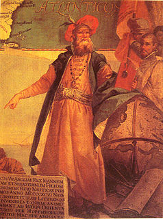
John Cabot was an Italian navigator and explorer. His 1497 voyage to the coast of North America under the commission of Henry VII of England is the earliest-known European exploration of coastal North America since the Norse visits to Vinland in the eleventh century. To mark the celebration of the 500th anniversary of Cabot's expedition, both the Canadian and British governments elected Cape Bonavista, Newfoundland as representing Cabot's first landing site. However, alternative locations have also been proposed.

Newfoundland is a large island off the east coast of the North American mainland and the most populous part of the Canadian province of Newfoundland and Labrador. It has 29 percent of the province's land area. The island is separated from the Labrador Peninsula by the Strait of Belle Isle and from Cape Breton Island by the Cabot Strait. It blocks the mouth of the Saint Lawrence River, creating the Gulf of Saint Lawrence, the world's largest estuary. Newfoundland's nearest neighbour is the French overseas collectivity of Saint Pierre and Miquelon.

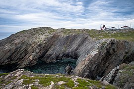
Cape Bonavista Light is a lighthouse located on Cape Bonavista, Newfoundland. The lighthouse, which operated from 1843 until 1962, is now a provincial museum, containing an exhibition about life in a lighthouse during the 1870s.
The Ryan Premises is a National Historic Site of Canada located in the town of Bonavista, Newfoundland and Labrador. It is preserved as an example of a large-scale merchant operation in a Newfoundland outport.