
The Gulf of Saint Lawrence is the outlet of the North American Great Lakes via the Saint Lawrence River into the Atlantic Ocean. The gulf is a semi-enclosed sea, covering an area of about 226,000 square kilometres (87,000 sq mi) and containing about 34,500 cubic kilometres (8,300 cu mi) of water, which results in an average depth of 152 metres (499 ft).
The Canso Causeway is a 1,385 m (4,544 ft) rock-fill causeway in Nova Scotia, Canada.

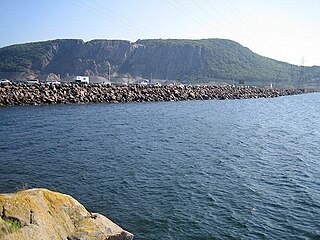
The Strait of Canso is a strait located in the province of Nova Scotia, Canada. It divides the Nova Scotia peninsula from Cape Breton Island.
Havre Boucher is a community in Antigonish County, Nova Scotia, Canada.

Canso is a community in Guysborough County, on the north-eastern tip of mainland Nova Scotia, Canada, next to Chedabucto Bay. In January 2012, it ceased to be a separate town and as of July 2012 was amalgamated into the Municipality of the District of Guysborough.

The Canso Canal is a short canal located in Nova Scotia, Canada.
Point Tupper is a rural community located in Richmond County, Nova Scotia on the Strait of Canso in western Cape Breton Island.
The Nova Scotia peninsula is a peninsula on the Atlantic coast of North America.
Creignish is a community in the Canadian province of Nova Scotia, located in Inverness County on Cape Breton Island near the mouth of the Strait of Canso.
Port Hastings is a Canadian rural community in Inverness County, Nova Scotia.

The Canso Canal Bridge is a rotating swing bridge in Nova Scotia, Canada. It crosses the Canso Canal at the eastern end of the Canso Causeway. The bridge carries the 2 traffic lanes of Highway 104 as well as a single track railway line operated by the Cape Breton and Central Nova Scotia Railway (CBNS).

The Raid on Canso was an attack by French forces from Louisbourg on the British outpost Fort William Augustus at Canso, Nova Scotia shortly after war declarations opened King George's War. The French raid was intended to boost morale, secure Louisbourg's supply lines with the surrounding Acadian settlements, and deprive Britain of a base from which to attack Louisbourg. There were 50 English families in the settlement. While the settlement was utterly destroyed, the objective failed, since the British launched an attack on Louisbourg in 1745, using Canso as a staging area.
Aulds Cove is a community in the Canadian province of Nova Scotia, located in both Antigonish County and Guysborough County.
Petit-de-Grat is a small Acadian community in the Canadian province of Nova Scotia, located in Richmond County on Petit-de-Grat Island. Its name comes from the Basque word "dégrat" which means "fishing station" or "whaling station".
Johnstown is a small community in the Canadian province of Nova Scotia, located in Richmond County on Cape Breton Island. The altar in the vestry of Sacred Heart Church in Johnstown is reported to have come from Fortress Louisbourg before the final siege.

The Battle of Winnepang occurred during Dummer's War when New England forces attacked Mi'kmaq at present day Jeddore Harbour, Nova Scotia. The naval battle was part of a campaign ordered by Governor Richard Philipps to retrieve over 82 New England prisoners taken by the Mi'kmaq in fishing vessels off the coast of Nova Scotia. The New England force was led by Ensign John Bradstreet and fishing Captain John Elliot.
St. George's Bay is a bay in the Canadian province of Nova Scotia. It is located on the north shore of the province fronting both the Nova Scotia peninsula and Cape Breton Island, thus comprising a sub-basin of the Gulf of St. Lawrence.
Fort William Augustus was a British fort built on Grassy Island off of Canso, Nova Scotia during the lead up to Father Rale's War (1720). In the wake of The Squirrel Affair and the British attack on Fort St. Louis, Cyprian Southack urged Governor Richard Philipps to build the fort. The Fort was named after King George's son Prince William, Duke of Cumberland.
Maritime Launch Services (MLS) is a Canadian space transport services company founded in 2016 and headquartered in Nova Scotia, Canada. MLS will rely on Ukrainian Cyclone-4M rockets by Yuzhnoye to launch polar and sun synchronous orbit from Canso, Nova Scotia. MLS is a joint venture of three U.S.-based firms.
This page is based on this
Wikipedia article Text is available under the
CC BY-SA 4.0 license; additional terms may apply.
Images, videos and audio are available under their respective licenses.
