Cape Cod Canal Railroad Bridge

Last updated
Cape Cod Canal Railroad Bridge
Cape Cod Canal - Railroad Bridge.jpg
Cape Cod Canal Railroad Bridge in 2005
Coordinates 41°44′31″N70°36′49″W / 41.74194°N 70.61361°W / 41.74194; -70.61361
Carries
   CapeFLYER
Crosses Cape Cod Canal
Locale Bourne, Massachusetts
Maintained by United States Army Corps of Engineers
Characteristics
Design Vertical lift bridge
Width27 feet (8.2 m) [1]
Height271 feet (83 m) (towers) [1]
Longest span544 feet (166 m) [1]
Clearance below 135 feet (41 m) (raised) [1]
History
Construction startDecember 18, 1933 [2]
OpenedDecember 29, 1935 [2]
Location
Cape Cod Canal Railroad Bridge

The Cape Cod Canal Railroad Bridge (also known as the Buzzards Bay Railroad Bridge) is a vertical lift bridge in Bourne, Massachusetts near Buzzards Bay that carries railroad traffic across the Cape Cod Canal, connecting Cape Cod with the mainland.

Contents

Design and construction

Bridge after construction, December 1935 Massachusetts - Bedford through Bourne - NARA - 23941239 (cropped).jpg
Bridge after construction, December 1935
The U.S. Navy frigate USS Underwood passing under the bridge Underwood under Buzzards Bay Bridge.jpg
The U.S. Navy frigate USS Underwood passing under the bridge

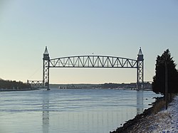
The bridge was constructed beginning in 1933 by the Public Works Administration from a design by firms Parsons, Klapp, Brinckerhoff, and Douglas as well as Mead and White (both of New York), for the United States Army Corps of Engineers, which operates both the bridge and the canal.

The bridge has a 544-foot (166 m) main span, with a 135-foot (41 m) clearance when raised, [1] uses 1,100-short-ton (1,000 t) [3] counterweights on each end, and opened on December 29, 1935. [2] The bridge replaced a bascule bridge that had been built in 1910.

At the time of its completion, it was the longest vertical lift span in the world. [4] It is now the second longest lift bridge in the United States, the longest being the Arthur Kill Vertical Lift Bridge between New Jersey and Staten Island, New York.

Maintenance and current use

Cape Cod canal railroad bridge opening

The bridge is owned, operated and maintained by the US Army Corps of Engineers. In 2002, the bridge underwent a major rehabilitation, including replacement of cables, machinery, and electrical systems, at a cost of $30 million and was reopened in 2003.

The rail line on either side of the bridge is owned by Massachusetts Department of Transportation, and is used year-round by the Massachusetts Coastal Railroad for their refuse trains and other freight operations. The bridge is also used by seasonal tourist trains operated by the Cape Cod Central Railroad, as well as the MBTA's seasonal CapeFLYER service, which runs between Boston and Hyannis.

See also

Related Research Articles

<span class="mw-page-title-main">Cape Cod</span> Peninsula in Massachusetts, United States

Cape Cod is a peninsula extending into the Atlantic Ocean from the southeastern corner of Massachusetts, in the northeastern United States. Its historic, maritime character and ample beaches attract heavy tourism during the summer months. The name Cape Cod, coined in 1602 by Bartholomew Gosnold, is the ninth oldest English place-name in the U.S.

<span class="mw-page-title-main">Cape Cod Canal</span> Waterway in Massachusetts

The Cape Cod Canal is an artificial waterway in Massachusetts connecting Cape Cod Bay in the north to Buzzards Bay in the south, and is part of the Atlantic Intracoastal Waterway. The approximately 7.4-mile-long (11.9 km) canal traverses the neck of land joining Cape Cod to the state's mainland. It mostly follows tidal rivers widened to 480 feet (150 m) and deepened to 32 feet (9.8 m) at mean low water, shaving up to 135 miles (217 km) off the journey around the cape for its approximately 14,000 annual users.

<span class="mw-page-title-main">Wareham, Massachusetts</span> Town in Massachusetts, United States

Wareham is a town in Plymouth County, Massachusetts, United States. As of the 2022 census, the town had a population of 23,303.

<span class="mw-page-title-main">Bourne, Massachusetts</span> Town in Massachusetts, United States

Bourne is a town in Barnstable County, Massachusetts, United States. The population was 20,452 at the 2020 census.

<span class="mw-page-title-main">Sandwich, Massachusetts</span> Town in Massachusetts, United States

Sandwich is a town in Barnstable County, Massachusetts, United States and is the oldest town on Cape Cod. The town motto is Post tot Naufracia Portus, "after so many shipwrecks, a haven". The population was 20,259 at the 2020 census.

<span class="mw-page-title-main">Massachusetts Route 25</span> Highway in Massachusetts

Route 25 is a 10-mile-long (16 km) freeway located in Plymouth County and Barnstable County, Massachusetts, United States. The route is a nominally east–west highway, and less commonly known as the Blue Star Memorial Highway. An eastward continuation of Interstate 495, Route 25 provides freeway access to Cape Cod. The route's western terminus is at a trumpet interchange with I-495 and I-195 in West Wareham. The route has three numbered interchanges along its length before terminating at the northern end of the Bourne Bridge in Bourne; the mainline of Route 25 continues across the bridge and over the Cape Cod Canal as Massachusetts Route 28 south.

<span class="mw-page-title-main">Cape Cod Central Railroad</span> Heritage railroad in Massachusetts, US

The Cape Cod Central Railroad is a heritage railroad located on Cape Cod, Massachusetts. It operates on a rail line known as the Cape Main Line which is owned by Massachusetts Department of Transportation. The line was previously owned and operated by the Cape Cod Railroad, the Old Colony Railroad, and later the New Haven Railroad, each of which operated passenger trains on the line from 1854 to 1959. Although its namesake is the former Cape Cod Central Railroad (1861–1868), the two companies are unrelated.

<span class="mw-page-title-main">Cape Cod Railroad</span> Railroad in southeastern Massachusetts, US

The Cape Cod Railroad is a railroad in southeastern Massachusetts, running from Pilgrim Junction in Middleborough across the Cape Cod Canal Railroad Bridge, where it splits towards Hyannis in one direction and Falmouth in the other. It was incorporated in 1846 as the Cape Cod Branch Railroad to provide a rail link from the Fall River Railroad line in Middleborough to Cape Cod.

<span class="mw-page-title-main">Bourne Bridge</span> Bridge in Bourne, Massachusetts

The Bourne Bridge in Bourne, Massachusetts, carries Route 28 across the Cape Cod Canal, connecting Cape Cod with the rest of Massachusetts. It won the American Institute of Steel Construction's Class "A" Award of Merit as the "Most Beautiful Steel Bridge" in 1934. Most traffic approaching from the west follows Route 25 which ends at the interchange with US 6 and Route 28 just north of the bridge. The highway provides freeway connections from Interstate 495 and Interstate 195.

The Sagamore Bridge in Sagamore, Massachusetts carries Route 6 and the Claire Saltonstall Bikeway across the Cape Cod Canal, connecting Cape Cod with the mainland of Massachusetts. It is the more northeastern of two automobile canal crossings, the other being the Bourne Bridge. Most traffic approaching from the north follows Massachusetts Route 3 which ends at Route 6 just north of the bridge, and the bridge provides direct expressway connections from Boston and Interstate 93.

<span class="mw-page-title-main">Old Colony Lines</span> Commuter rail lines in Massachusetts, US

The Old Colony Lines are a pair of branches of the MBTA Commuter Rail system, connecting downtown Boston, Massachusetts with the South Shore and cranberry-farming country to the south and southeast. The two branches operate concurrently for 10 miles (16 km) via the Old Colony Mainline from South Station to Braintree station. The Middleborough/Lakeville Line then winds south through Holbrook, Brockton, Bridgewater, Middleborough, and Lakeville via the Middleborough Main Line and Cape Main Line. The Kingston Line heads southeast to serve Weymouth, Abington, Whitman, Hanson, Halifax, and Kingston by way of the Plymouth branch. Limited service to Plymouth was provided prior to April 2021 but was cut due to low ridership and budget constraints. The Greenbush Line, which was also part of the Old Colony Division, was reactivated in 2007 as a separate project.

<span class="mw-page-title-main">Scusset Beach State Reservation</span>

Scusset Beach State Reservation is a state-operated, public recreation area located in the town of Sandwich in Barnstable County, Massachusetts, at the east end of the Cape Cod Canal on land formerly part of Sagamore Hill Military Reservation. In addition to its beach and campgrounds, prominent features of the park include Sagamore Hill, a one-time Native American meeting ground and site of World War II coastal fortifications, and a 3,000-foot (910 m) stone jetty that separates the canal and beach. Unlike most of Sandwich, this section of the town is on the mainland side of the Cape Cod Canal. The state park is managed by the Massachusetts Department of Conservation and Recreation under a lease agreement with the U.S. Army Corps of Engineers.

<span class="mw-page-title-main">Buzzards Bay station</span> Train station in Barnstable, Massachusetts, US

Buzzards Bay station is a train station located on Main Street in Buzzards Bay, Massachusetts. The site also contains an interlocking tower. The Cape Cod Canal Railroad Bridge is adjacent.

<i>CapeFlyer</i> Seasonal rail service in Massachusetts

The CapeFlyer is a passenger rail service in Massachusetts between Boston and Cape Cod that began in 2013. It is operated by the Cape Cod Regional Transit Authority (CCRTA) in collaboration with the Massachusetts Bay Transportation Authority (MBTA) and the Massachusetts Department of Transportation (MassDOT). The service runs on the weekends, beginning Friday evenings and including holidays, between Memorial Day weekend and Labor Day weekend.

The Cape Cod & Hyannis Railroad was a railroad that provided tourist and seasonal passenger services in Southeastern Massachusetts in the 1980s. Its primary service operated from the Braintree MBTA station to Hyannis on Cape Cod; branches to Attleboro and Falmouth also operated in some years. The service ended after the 1988 summer season amid early-1989 state budget cuts in Massachusetts; much of the same trackage is being used for the seasonal CapeFLYER service.

<span class="mw-page-title-main">Bournedale station</span>

Bournedale station was a railroad station serving Bournedale, Massachusetts. Opened in 1848, it was relocated in 1911 during construction of the Cape Cod Canal and closed in the 1920s.

<span class="mw-page-title-main">Bourne station</span>

Bourne station is a train station in Bourne, Massachusetts, served by the CapeFlyer.

<span class="mw-page-title-main">Bourne Highway Bridge</span> Bridge in Bourne, Massachusetts

The Bourne Highway Bridge was a bascule bridge in the town of Bourne, Massachusetts, that spanned the Cape Cod Canal. It was in use from 1911 until 1935.

References

  1. 1 2 3 4 5 50th Anniversary Cape Cod Canal Bridges, Bourne, Massachusetts 1935-1985. Waltham, Massachusetts: U.S. Army Corps of Engineers. 1985. p. 4.
  2. 1 2 3 Anniversary, p. 3
  3. Cape Cod Canal, p.6
  4. Anniversary, p. 2

Further reading