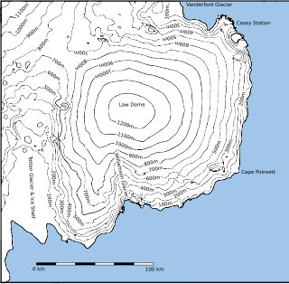
Law Dome is a large ice dome which rises to 1,395 metres (4,580 ft) directly south of Cape Poinsett, Antarctica. The feature was roughly mapped by the United States Geological Survey from aerial photographs taken by U.S. Navy Operation Highjump, 1946–47, and has been the subject of intensive glaciological and geophysical surveys by Australian National Antarctic Research Expeditions between 1962 and 1965. It was named by the Antarctic Names Committee of Australia for Phillip Law, Director of the Australian Antarctic Division from 1949 to 1966.

Cape Morse is a low, ice-covered cape which marks the east side of the entrance to Porpoise Bay and forms the division between Banzare Coast and Clarie Coast in Wilkes Land, Antarctica. It was delineated from air photos taken by U.S. Navy Operation Highjump in 1946–47, and was named by the Advisory Committee on Antarctic Names for William H. Morse, purser's steward on the brig Porpoise of the United States Exploring Expedition (1838–42) under Charles Wilkes.
The Mawson Coast is that portion of the coast of Mac. Robertson Land, Antarctica, lying between William Scoresby Bay, at 59°34′E, and Murray Monolith, at 66°54′E. The coast was sighted during the British Australian New Zealand Antarctic Research Expedition (BANZARE), 1929–30, under Sir Douglas Mawson. Further exploration and landings at Cape Bruce and Scullin Monolith were made during BANZARE, 1930–31. Mawson Coast was named by the Antarctic Names Committee of Australia after Mawson in recognition of his great contribution to Antarctic exploration.
The Scott Mountains are a large number of isolated peaks lying south of Amundsen Bay in Enderby Land of East Antarctica, Antarctica. Discovered on 13 January 1930 by the British Australian New Zealand Antarctic Research Expedition (BANZARE) under Sir Douglas Mawson. He named the feature Scott Range after Captain Robert Falcon Scott, Royal Navy. The term mountains is considered more appropriate because of the isolation of its individual features.
Cape Longing is a rocky cape on the east coast of Graham Land, Antarctica, forming the south end of a large ice-covered promontory which marks the west side of the south entrance to Prince Gustav Channel. It was discovered by the Swedish Antarctic Expedition under Otto Nordenskiöld in 1902, and so named by him because from the position of his winter hut on Snow Hill Island the cape lay in the direction of his "land of longing" which he was anxious to explore.

Adams Glacier, also known as John Quincy Adams Glacier, is a broad channel glacier in Wilkes Land, Antarctica which is over 20 miles (32 km) long. It debouches into the head of Vincennes Bay, just east of Hatch Islands. It was first mapped in 1955 by G.D. Blodgett from aerial photographs taken by U.S. Navy Operation Highjump (1947), and it was named by the Advisory Committee on Antarctic Names (US-ACAN) for John Quincy Adams, sixth President of the United States. Adams was instrumental while later serving as U.S. representative from Massachusetts in gaining congressional authorization of the United States Exploring Expedition (1838–42) under Lieutenant Charles Wilkes, and perpetuating the compilation and publication of the large number of scientific reports based on the work of this expedition.

Posadowsky Glacier is a glacier about 9 nautical miles long, flowing north to Posadowsky Bay immediately east of Gaussberg. Posadowsky Bay is an open embayment, located just east of the West Ice Shelf and fronting on the Davis Sea in Kaiser Wilhelm II Land. Kaiser Wilhelm II Land is the part of East Antarctica lying between Cape Penck, at 87°43'E, and Cape Filchner, at 91°54'E, and is claimed by Australia as part of the Australian Antarctic Territory. Other notable geographic features in this area include Drygalski Island, located 45 mi NNE of Cape Filchner in the Davis Sea, and Mirny Station, a Russian scientific research station.
Conradi Peak is an isolated peak, 1,040 metres (3,410 ft) high, rising northward of the Napier Mountains and inland from the coast, some 19 nautical miles (35 km) southwest of Cape Borley. It was discovered in January 1930 by the British Australian New Zealand Antarctic Research Expedition (BANZARE) under Mawson, who named it after a prominent member of the South African government who, in 1929, rendered much help to BANZARE during the stay of the Discovery at Cape Town.

Wilkinson Glacier is a glacier on the south side of Protector Heights on Pernik Peninsula, Loubet Coast in Graham Land, flowing westward into Lallemand Fjord to the south of Holdfast Point. Mapped from air photos taken by Falkland Islands and Dependencies Aerial Survey Expedition (FIDASE) (1956–57). Named by United Kingdom Antarctic Place-Names Committee (UK-APC) for Captain John V. Wilkinson, Royal Navy, captain of HMS Protector in these waters, 1955–56 and 1956-57.
Cape Borley is an ice-covered cape protruding slightly from the coast midway between Cape Batterbee and Magnet Bay. It was discovered in January 1930 by the British Australian New Zealand Antarctic Research Expedition (BANZARE) under Mawson, who named it for John Oliver Borley, a member of the Discovery Committee, who assisted BANZARE with arrangements to take over the Discovery.
Neill Peak is a mountain, 460 m, standing 3 nautical miles (6 km) southwest of Scullin Monolith in Mac. Robertson Land. Discovered on February 13, 1931 by British Australian New Zealand Antarctic Research Expedition (BANZARE) under Mawson, who presumably applied the name.
Dodd Nunatak is a nunatak 2.5 nautical miles (5 km) west of Mount Cox in the northwest portion of the Emlen Peaks in the Usarp Mountains, a major mountain range within Victoria Land, Antarctica. The geographical feature was first mapped by the United States Geological Survey from surveys and U.S. Navy air photos, 1960–63, and was named by the Advisory Committee on Antarctic Names for Walter H. Dodd of the Public Information Office, National Science Foundation, who worked at McMurdo Station, Hut Point Peninsula, Ross Island, in the 1966–67 and 1967–68 austral summer months. The nunatak lies situated on the Pennell Coast, a portion of Antarctica lying between Cape Williams and Cape Adare.
Cape Pepin is an ice-covered cape between Ravin Bay and Barre Glacier. Discovered in 1840 by the French expedition under Captain Jules Dumont d'Urville and named by him for his wife Adele Pepin. The area was charted by the Australasian Antarctic Expedition in 1912-13, and again by the British Australian New Zealand Antarctic Research Expedition (BANZARE) in 1931, both under Mawson. The cape was more recently delineated from aerial photographs taken by U.S. Navy Operation Highjump, 1946-47.
Cape McCormick is a cape marking the eastern extremity of Adare Peninsula in Victoria Land, Antarctica. It was discovered by Captain James Clark Ross in 1841, who named it for Robert McCormick, surgeon on HMS Erebus.
Mount Marr is a rock peak which rises above the surrounding ice surface 8 nautical miles (15 km) south of Johnston Peak and 8 nautical miles west of Douglas Peak, in Enderby Land, Antarctica. It was discovered in January 1930 by the British Australian New Zealand Antarctic Research Expedition (BANZARE) under Douglas Mawson and was named after James W.S. Marr, a zoologist on the expedition, whose services were lent to BANZARE by the British Discovery Investigations Committee.
Sandford Glacier is a channel glacier flowing to the east side of Porpoise Bay, about 25 nautical miles (46 km) south-southwest of Cape Morse. Delineated from air photos taken by U.S. Navy Operation Highjump (1946–47). Named by Advisory Committee on Antarctic Names (US-ACAN) for Joseph P. Sandford, Passed Midshipman on the brig Porpoise of the United States Exploring Expedition (1838–42) under Wilkes.
Mount Riiser-Larsen is a prominent mountain, 870 m, standing at the northwest end of the Tula Mountains on the east side of Amundsen Bay. It was named by the British Australian New Zealand Antarctic Research Expedition (BANZARE) under Mawson in January 1930 for Captain Hjalmar Riiser-Larsen, the leader of a Norwegian expedition in the Norvegia which also explored the area in that season.
Mount Rivett is a bare rock mountain, the northeasternmost feature of the Gustav Bull Mountains in Mac. Robertson Land, Antarctica. On February 13, 1931, the British Australian New Zealand Antarctic Research Expedition (BANZARE) (1929–31) under Douglas Mawson made a landing on nearby Scullin Monolith. They named this mountain after Sir David Rivett, Deputy Chairman and Chief Executive Officer of the Australian Council for Scientific and Industrial Research, 1927-45.
Cape Leguillou is a point which forms the northern tip of Tower Island, at the northeast end of the Palmer Archipelago, Antarctica. It was charted by a French expedition under Captain Jules Dumont d'Urville, 1837–40, and named by him for Élie Le Guillou, a surgeon on the expedition ship Zélée. The name form approved is in agreement with the charts of the d'Urville expedition and has been consistently used since that time.

