
The Arctic Archipelago, also known as the Canadian Arctic Archipelago, is an archipelago lying to the north of the Canadian continental mainland, excluding Greenland and Iceland.

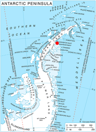
Palmer Land is the portion of the Antarctic Peninsula, Antarctica that lies south of a line joining Cape Jeremy and Cape Agassiz. This application of Palmer Land is consistent with the 1964 agreement between the Advisory Committee on Antarctic Names and the UK Antarctic Place-Names Committee, in which the name Antarctic Peninsula was approved for the major peninsula of Antarctica, and the names Graham Land and Palmer Land for the northern and southern portions, respectively. The line dividing them is roughly 69° S.
Odom Inlet is an ice-filled inlet 9 miles long, between Cape Howard and Cape MacDonald along the east coast of Palmer Land. It was discovered by members of the US Antarctic Service (USAS) who explored this coast from East Base both by land and from the air in 1940, and named for Howard Odom, radio operator at the East Base.

Shiver Point is a point, surmounted by a peak 670 cm high, 8 miles (13 km) west of Cape Fairweather on the east coast of Graham Land, Antarctica forming the west side of the entrance to Artanes Bay and the northeast side of the entrance to Vaughan Inlet.
Exasperation Inlet is a large ice-filled inlet, 16 miles (26 km) wide at its entrance between Foyn Point and Cape Disappointment, on the east coast of Graham Land. It was charted in 1947 by the Falkland Islands Dependencies Survey, who so named it because the disturbed nature of the ice in the vicinity caused considerable difficulty to sledging parties.
New Bedford Inlet is a large pouch-shaped, ice-filled embayment between Cape Kidson and Cape Brooks, along the east coast of Palmer Land. Discovered and photographed from the air in December 1940 by members of the United States Antarctic Service (USAS), and named after New Bedford, Massachusetts, the centre of the New England whaling industry in the middle of the 19th century.
Bryan Glacier is a glacier that flows north along the eastern side of the Werner Mountains and merges with Douglas Glacier on entering New Bedford Inlet in Palmer Land. It was mapped by the United States Geological Survey from ground surveys and from U.S. Navy air photos, 1961–67, and named by the Advisory Committee on Antarctic Names for Terry E. Bryan, glaciologist at Byrd Station, summer 1966–67.

Chamberlin Glacier is a glacier on the east side of Hemimont Plateau which flows northeast into Whirlwind Inlet about 4 nautical miles (7 km) southeast of Matthes Glacier, on the east coast of Graham Land.
Cape Darlington is an ice-covered headland which rises to 305 metres (1,000 ft), forming the south side of the entrance to Hilton Inlet, on the east coast of Palmer Land. It was discovered in 1940 by the United States Antarctic Service (USAS), but at that time it was thought to be an island. Its true nature was determined in an aerial flight by the Ronne Antarctic Research Expedition (RARE) under Finn Ronne, in November 1947. It was named by the USAS for Harry Darlington III, a member of the East Base sledging party that explored this coast as far south as Hilton Inlet. Darlington was also a member of the RARE.
Dawson Head is a high coastal point, or headland, along the northwest side of Lehrke Inlet on the east coast of Palmer Land, Antarctica. It was mapped by the United States Geological Survey in 1974, and named by the Advisory Committee on Antarctic Names for Captain Opie L. Dawson, commanding officer of the USCGC Glacier during the International Weddell Sea Oceanographic Expedition, 1968.
Punchbowl Glacier is a glacier that flows southwards between Poibrene Heights and Metlichina Ridge, and enters the north end of Exasperation Inlet, north of Jorum Glacier, on the east side of Graham Land, Antarctica. Surveyed by Falkland Islands Dependencies Survey (FIDS) in 1947 and 1955. The name applied by United Kingdom Antarctic Place-Names Committee (UK-APC) is descriptive of shape as the glacier is hemmed in by mountains.
Piggott Peninsula is a broad snow-covered peninsula between New Bedford Inlet and Wright Inlet on Lassiter Coast, Palmer Land, bounded to the west by Bryan Glacier and Swann Glacier. The feature was first seen from the air and photographed by the United States Antarctic Service (USAS) on December 30, 1940. It was mapped by United States Geological Survey (USGS) from surveys and U.S. Navy aerial photographs, 1961–67. Named by the United Kingdom Antarctic Place-Names Committee (UK-APC) in 1985 after William R. Piggott, British ionospheriscist and Head, Atmospheric Sciences Division, British Antarctic Survey (BAS), 1973–79.
Evans Glacier is a gently-sloping glacier 15 nautical miles (28 km) long and 4 nautical miles (7 km) wide, draining the southeast slopes of Travnik Buttress eastwards between Rugate Ridge and Poibrene Heights to flow into Vaughan Inlet on the east coast of Graham Land, Antarctica. It was discovered by Sir Hubert Wilkins in an aerial flight, December 20, 1928, and named "Evans Inlet" by him for E.S. Evans of Detroit. A further survey by the Falkland Islands Dependencies Survey in 1955 reported that this low-lying area is not an inlet, but is formed by the lower reaches of Hektoria Glacier and the feature now described.
Haley Glacier is a glacier, 8 nautical miles (15 km) long, draining southeast along the north side of Rowley Massif into Odom Inlet, on the east coast of Palmer Land, Antarctica. It was mapped by United States Geological Survey in 1974, and was named by the Advisory Committee on Antarctic Names for Philip H. Haley, a United States Antarctic Research Program biologist at Palmer Station, 1973.
Hilton Inlet is an ice-filled inlet, 22 kilometres (12 nmi) wide, which recedes about 41 kilometres (22 nmi) west from its entrance between Cape Darlington and Cape Knowles, along the east coast of Palmer Land, Antarctica. It was discovered by the United States Antarctic Service in 1940, and named for Donald C. Hilton, a member of the East Base sledge party that charted this coast as far south as this inlet.
Renaud Glacier is a heavily crevassed glacier on the east side of Hemimont Plateau flowing southeast to enter Seligman Inlet between Lewis Glacier and Choyce Point, on the east coast of Graham Land. The glacier was first photographed by the United States Antarctic Service (USAS), 1939–41. Named by United Kingdom Antarctic Place-Names Committee (UK-APC) for Andre Renaud, Swiss glaciologist and chairman of the Swiss Glacier Commission, 1955–74.

Cape Robinson is a cape marking the east end of Cole Peninsula, between Cabinet and Mill Inlets on Foyn Coast, Graham Land. Sir Hubert Wilkins, while on his flight of December 20, 1928 along this coast, named an island for W.S. Robinson of London and Australia, which he reported to lie in about 67°20′S61°40′W. Absence of photographs of this island by Wilkins has prevented its positive reidentification. For this reason, and for the sake of historical continuity, it is recommended that the east end of the peninsula here described be given the name Cape Robinson. This cape was charted by the Falkland Islands Dependencies Survey (FIDS) and photographed from the air by the Ronne Antarctic Research Expedition (RARE) in 1947.

Kunino Point is a rocky point on Blagoevgrad Peninsula, Oscar II Coast, Graham Land in Antarctica, the south extremity of an eponymous ridge extending 2.4 by 2 km on the north coast of Exasperation Inlet. Formed in 2002 as a result of the disintegration of Larsen Ice Shelf in the area.
Akra Peninsula is the mostly ice-covered peninsula projecting 11 km eastwards from Oscar II Coast in Graham Land, and 5.2 km wide, bounded by Exasperation Inlet to the north and Scar Inlet to the south, and ending in Cape Disappointment to the east. It was formed as a result of the break-up of Larsen Ice Shelf in the area, and the retreat of Pequod Glacier in the early 21st century. The feature is named after the ancient town of Akra in Southeastern Bulgaria.
