
Tower Island is an Antarctic island 9 kilometres (5 nmi) long and 305 m (1,001 ft) high. It marks the north-east extent of Palmer Archipelago. It lies 37 kilometres (20 nmi) north-east of Trinity Island, separated by Gilbert Strait. Both islands are separated from the Davis Coast to the south by Orléans Strait, running northeast–southwest. The Pearl Rocks lie off the West Coast of Tower Island.
Laurie Island is the second largest of the South Orkney Islands. The island is claimed by both Argentina as part of Argentine Antarctica, and the United Kingdom as part of the British Antarctic Territory. However, under the Antarctic Treaty System all sovereignty claims are frozen, as the island lies south of the parallel 60°. Buchanan Point at the north-eastern end of the island, with Cape Whitson on its south coast, are Important Bird Areas.

Adelaide Island is a large, mainly ice-covered island, 139 kilometres (75 nmi) long and 37 kilometres (20 nmi) wide, lying at the north side of Marguerite Bay off the west coast of the Antarctic Peninsula. The Ginger Islands lie off the southern end. Mount Bodys is the easternmost mountain on Adelaide Island, rising to over 1,220 m. The island lies within the Argentine, British and Chilean Antarctic claims.

Snow Hill Island is an almost completely snowcapped island, 33 km (21 mi) long and 12 km (7.5 mi) wide, lying off the east coast of the Antarctic Peninsula. It is separated from James Ross Island to the north-east by Admiralty Sound and from Seymour Island to the north by Picnic Passage. It is one of several islands around the peninsula known as Graham Land, which is closer to Chile, Argentina and South America than any other part of the Antarctic continent.

Arrowsmith Peninsula is a cape about 40 miles (64 km) long on the west coast of Graham Land, west of Forel Glacier, Sharp Glacier and Lallemand Fjord, and northwest of Bourgeois Fjord, with Hanusse Bay lying to the northwest. It was surveyed by the Falkland Islands Dependencies Survey (FIDS) in 1955-58 and named for Edwin Porter Arrowsmith, Governor of the Falkland Islands.

Barff Peninsula is a peninsula forming the east margin of Cumberland East Bay, South Georgia Island. It is 8 miles (13 km) long and extends northwest from Sörling Valley to Barff Point, its farthest extremity. It was probably first seen by the British expedition under James Cook in 1775. The peninsula as a whole takes its name from Barff Point, which was named for Royal Navy Lieutenant A.D. Barff of HMS Sappho, who, assisted by Captain C.A. Larsen, sketched a map of Cumberland Bay in 1906. Barff Point is considered the eastern headland of East Cumberland Bay.

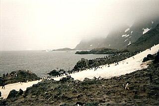
The Bay of Isles is a bay 9 miles (14 km) wide and receding 3 miles (5 km), lying between Cape Buller and Cape Wilson along the north coast of South Georgia. It was discovered in 1775 by a British expedition under James Cook and so named by him because numerous islands lie in the bay. Of South Georgia's 31 breeding bird species, 17 are found here.
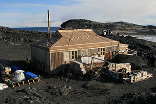
Cape Royds is a dark rock cape forming the western extremity of Ross Island, facing on McMurdo Sound, Antarctica. It was discovered by the British National Antarctic Expedition (BrNAE) (1901–1904) and named for Lieutenant Charles Royds, Royal Navy, who acted as meteorologist on the expedition. Royds subsequently rose to become an Admiral and was later Commissioner of the Metropolitan Police, London. The cape is the site of Shackleton's Hut, the expedition camp of the British Antarctic Expedition, 1907–09.
Buchanan Point is a headland 5 km (3.1 mi) north-west of Cape Dundas and 2 km (1.2 mi) south-east of Mackintosh Cove, at the north-eastern end of Laurie Island in the South Orkney Islands of Antarctica.
Jessie Bay is a bay 4 nautical miles (7 km) wide, lying between Mackenzie Peninsula and Pirie Peninsula, on the north side of Laurie Island in the South Orkney Islands. Apparently seen in the course of the joint cruise by Captain George Powell, a British sealer, and Captain Nathaniel Palmer, an American one. In 1821, it was roughly charted by Captain James Weddell, a British sealer. It was surveyed in 1903 by the Scottish National Antarctic Expedition of William S. Bruce, who named this bay for his wife, Jessie Mackenzie Bruce. He also named a cove in the bay, Sheila Cove, for his daughter.

Pirie Peninsula is a narrow peninsula extending 6 km (3.7 mi) northward from the center of Laurie Island, in the South Orkney Islands of Antarctica. The peninsula was surveyed in 1903 by the Scottish National Antarctic Expedition under Bruce, who named it for Dr Harvey Pirie, surgeon and geologist of the expedition.

Ferguslie Peninsula is a peninsula 2.4 km (1.5 mi) long, lying between Browns Bay and Macdougal Bay on the north coast of Laurie Island, in the South Orkney Islands of Antarctica. The peninsula was charted in 1903 by the Scottish National Antarctic Expedition under William Speirs Bruce, who named it for Ferguslie, the residence of James Coats, chief patron of the expedition.
Methuen Cove is a cove between Cape Anderson and Cape Whitson on the south coast of Laurie Island, in the South Orkney Islands off Antarctica. It was charted in 1903 by the Scottish National Antarctic Expedition under William Speirs Bruce, who named it after H. Methuen, the accountant of the expedition.
Mill Cove is a cove entered between Cape Anderson and Valette Island on the south coast of Laurie Island, in the South Orkney Islands off Antarctica. It was charted in 1903 by the Scottish National Antarctic Expedition under William Speirs Bruce, who named it for Hugh Robert Mill, a British geographer and polar historian.
Marr Bay is a bay lying between Cape Valavielle and Fraser Point along the north coast of Laurie Island, in the South Orkney Islands off Antarctica. It was mapped in 1903 by the Scottish National Antarctic Expedition under William Speirs Bruce, and was named for James W.S. Marr, a member of the Discovery Committee zoological staff, by personnel on the Discovery II following their survey of the South Orkney Islands in 1933.
Point Martin is a point on the east side of Mossman Peninsula, 1.5 km (0.93 mi) north-west of Cape Murdoch, on the south coast of Laurie Island in the South Orkney Islands of Antarctica. It was charted in 1903 by the Scottish National Antarctic Expedition under Bruce, who named it for J. Martin, an able seaman on the expedition ship Scotia.
Thomson Point is a point on the east side of Pirie Peninsula, 1.7 nautical miles (3.1 km) southeast of Cape Mabel, on the north coast of Laurie Island in the South Orkney Islands.
Cape Valavielle is a cape marking the north end of Watson Peninsula on the north coast of Laurie Island, in the South Orkney Islands.
Cape Robertson is a cape which marks the west side of the entrance to Jessie Bay, in the north-west part of Laurie Island, in the South Orkney Islands of Antarctica.
Rudmose Rocks is a group of rocks 0.4 nautical miles north-northwest of Cape Geddes, off the north coast of Laurie Island in the South Orkney Islands. The rocks were charted in 1903 by the Scottish National Antarctic Expedition under William Speirs Bruce, who named them for Robert Neal Rudmose-Brown, naturalist of the expedition.
