Related Research Articles

Mount Erebus is the second-highest volcano in Antarctica, the highest active volcano in Antarctica, and the southernmost active volcano on Earth. It is the sixth-highest peak of an island and the second most prominent mountain in Antarctica after Mount Vinson. It has a summit elevation of 3,794 metres (12,448 ft). It is located in the Ross Dependency on Ross Island, which is also home to three inactive volcanoes: Mount Terror, Mount Bird, and Mount Terra Nova. The mountain was named by Captain James Clark Ross in 1841 for his ship, the Erebus.

Thurston Island is a largely ice-covered, glacially dissected island, 135 nautical miles long and 55 nautical miles wide, lying between between Amundsen Sea and Bellingshausen Sea a short way off the northwest end of Ellsworth Land, Antarctica. The island is separated from the mainland by Peacock Sound, which is occupied by the west portion of Abbot Ice Shelf.
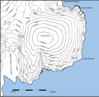
Law Dome is a large ice dome which rises to 1,395 metres (4,580 ft) directly south of Cape Poinsett, Antarctica. The feature was roughly mapped by the United States Geological Survey from aerial photographs taken by U.S. Navy Operation Highjump, 1946–47, and has been the subject of intensive glaciological and geophysical surveys by Australian National Antarctic Research Expeditions between 1962 and 1965. It was named by the Antarctic Names Committee of Australia for Phillip Law, Director of the Australian Antarctic Division from 1949 to 1966.
Cape Folger is an ice-covered cape forming the east side of the entrance to Vincennes Bay on the Budd Coast of Antarctica. The position of Cape Folger correlates closely with the west end of Charles Wilkes' "Budd's High Land", as charted as a coastal landfall by the United States Exploring Expedition in 1840. The cape was mapped from aerial photographs taken by U.S. Navy Operation Highjump, 1946–47, and was named by the Advisory Committee on Antarctic Names for Commander Edward C. Folger, Jr., U.S. Navy, commander of the icebreaker Edisto which assisted Operation Windmill parties in establishing astronomical control stations in the Windmill Islands, close southwest in Vincennes Bay.
King Peninsula is an ice-covered peninsula, 100 nautical miles long and 20 nautical miles wide, lying south of Thurston Island and forming the south side of Peacock Sound, Antarctica. It projects from the continental ice sheet and trends west between the Abbot Ice Shelf and Cosgrove Ice Shelf to terminate at the Amundsen Sea.
Cape Hordern is an ice-free cape, overlain by morainic drift, at the northwest end of the Bunger Hills in Antarctica. It was probably sighted from Watson Bluff by A.L. Kennedy and other members of the Western Base Party of the Australasian Antarctic Expedition under Mawson, 1911–1914, who charted the west wall of what appeared to be two small islands lying north of Cape Hoadley in about 100°35′E. It was named "Hordern Island" by Mawson for Sir Samuel Hordern of Sydney, a patron of the expedition. It was renamed Cape Hordern by the Advisory Committee on Antarctic Names (US-ACAN) following correlation of Kennedy's map with the US-ACAN map of 1955 compiled from aerial photographs taken by U.S. Navy Operation Highjump, 1946–47.
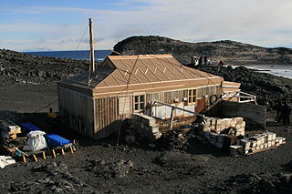
Cape Royds is a dark rock cape forming the western extremity of Ross Island, facing on McMurdo Sound, Antarctica. It was discovered by the British National Antarctic Expedition (BrNAE) (1901–1904) and named for Lieutenant Charles Royds, Royal Navy, who acted as meteorologist on the expedition. Royds subsequently rose to become an Admiral and was later Commissioner of the Metropolitan Police, London. The cape is the site of Shackleton's Hut, the expedition camp of the British Antarctic Expedition, 1907–09.

Posadowsky Glacier is a glacier about 9 nautical miles long, flowing north to Posadowsky Bay immediately east of Gaussberg. Posadowsky Bay is an open embayment, located just east of the West Ice Shelf and fronting on the Davis Sea in Kaiser Wilhelm II Land. Kaiser Wilhelm II Land is the part of East Antarctica lying between Cape Penck, at 87°43'E, and Cape Filchner, at 91°54'E, and is claimed by Australia as part of the Australian Antarctic Territory. Other notable geographic features in this area include Drygalski Island, located 45 mi NNE of Cape Filchner in the Davis Sea, and Mirny Station, a Russian scientific research station.
On the continent of Antarctica, the Aramis Range is the third range south in the Prince Charles Mountains, situated 11 miles southeast of the Porthos Range and extending for about 30 miles in a southwest–northeast direction. It was first visited in January 1957 by Australian National Antarctic Research Expeditions (ANARE) southern party led by W.G. Bewsher, who named it for a character in Alexandre Dumas' novel The Three Musketeers, the most popular book read on the southern journey.
Bon Docteur Nunatak, also known as Good Doctor Nunatak, is a small coastal nunatak, 28 metres (92 ft) high, standing at the west side of the Astrolabe Glacier Tongue, 400 m (1,300 ft) south of Rostand Island in the Geologie Archipelago of Antarctica. It was photographed from the air by U.S. Navy Operation Highjump, 1946–47, charted by the French Antarctic Expedition, 1952–53, and named for Dr Jean Cendron, the "good doctor", medical officer and biologist with the French Antarctic Expedition, 1951–52.

Breitfuss Glacier is a glacier 10 nautical miles (19 km) long, which flows southeast from Avery Plateau into Mill Inlet to the west of Cape Chavanne, on the east coast of Graham Land. It was charted by the Falkland Islands Dependencies Survey (FIDS) and photographed from the air by the Ronne Antarctic Research Expedition in 1947. It was named by the FIDS for Leonid Breitfuss, a German polar explorer, historian, and author of many polar bibliographies.

Buromskiy Island is a small island lying 0.6 km (0.37 mi) south of Haswell Island in the Haswell Islands of Antarctica. About 200 m long and 100 m wide, it was discovered and mapped by the Australasian Antarctic Expedition under Douglas Mawson, 1911–14. It was photographed by the Soviet expedition of 1958 and named for N.I. Buromskiy, expedition hydrographer who lost his life in the Antarctic in 1957. It lies 2.7 km north of Mabus Point, the site of Russia's Mirny Station.
Cape Kolosov is a point along the west side of the ice-covered peninsula that forms the east side of the entrance to Amundsen Bay, Antarctica. It was photographed in 1956 from Australian National Antarctic Research Expeditions aircraft, and rephotographed in 1958 by a Soviet expedition. The cape was named after the polar aviation navigator V. Kolosov, who died in the Arctic.

Elliott Glacier is a small channel glacier that drains northward to the Budd Coast of Antarctica, midway between Cape Hammersly and Cape Waldron. It was delineated from aerial photographs taken by U.S. Navy Operation Highjump (1946–47), and named by the Advisory Committee on Antarctic Names after Samuel Elliott, a midshipman on the sloop Vincennes during the United States Exploring Expedition (1838–42) under Lieutenant Charles Wilkes.
Cape Géodésie is a low, ice-covered point marked by prominent rock outcrops at its northeast end, lying 3 nautical miles (6 km) northwest of the mouth of Astrolabe Glacier, Antarctica. It was photographed from the air by U.S. Navy Operation Highjump, 1946–47. It was charted by the French Antarctic Expedition, 1951–52, and so named by them because of the extensive geodetic program undertaken in this region, particularly in the Geologie Archipelago close offshore.
Cape Hammersly is an ice-covered cape midway between Williamson Glacier and Totten Glacier on Budd Coast, Antarctica. It was delineated by G.D. Blodgett (1955) from aerial photographs taken by U.S. Navy Operation Highjump (1946–47), and named by the Advisory Committee on Antarctic Names for George W. Hammersly, a midshipman on the sloop Vincennes during the United States Exploring Expedition (1833–1842) under Lieutenant Charles Wilkes.
Maury Bay is an ice-filled bay indenting the coast of Antarctica just east of Cape Lewis. It was mapped by G.D. Blodgett in 1955 from aerial photographs taken by U.S. Navy Operation Highjump (1946–47), and named by the Advisory Committee on Antarctic Names for William Lewis Maury, lieutenant on the brig Porpoise during the United States Exploring Expedition (1838–42) under Lieutenant Charles Wilkes.
Holmes Glacier is a broad glacier debouching into the western part of Porpoise Bay about 10 nautical miles (20 km) south of Cape Spieden. It was delineated from aerial photographs taken by U.S. Navy Operation Highjump (1946–47), and was named by the Advisory Committee on Antarctic Names after Dr. Silas Holmes, Assistant Surgeon on the brig Porpoise during the United States Exploring Expedition (1838–42) under Lieutenant Charles Wilkes.
Landen Ridge is a narrow rock ridge at the east end of Cole Peninsula in Graham Land, Antarctica. During December 1947 it was charted by the Falkland Islands Dependencies Survey and photographed from the air by the Ronne Antarctic Research Expedition (RARE) under Finn Ronne. It was named by Ronne for David Landen of the United States Geological Survey, who assisted in planning the RARE photographic program and in correlating photographs after the expedition returned.
This is a list of rock formations in the French Antarctic territory of Adélie Land.
References
- ↑ "Cape Mikhaylov". Geographic Names Information System . United States Geological Survey, United States Department of the Interior . Retrieved 2013-09-24.
![]() This article incorporates public domain material from "Cape Mikhaylov". Geographic Names Information System . United States Geological Survey.
This article incorporates public domain material from "Cape Mikhaylov". Geographic Names Information System . United States Geological Survey.
| | This Wilkes Land location article is a stub. You can help Wikipedia by expanding it. |