Related Research Articles

The Amundsen Sea is an arm of the Southern Ocean off Marie Byrd Land in western Antarctica. It lies between Cape Flying Fish to the east and Cape Dart on Siple Island to the west. Cape Flying Fish marks the boundary between the Amundsen Sea and the Bellingshausen Sea. West of Cape Dart there is no named marginal sea of the Southern Ocean between the Amundsen and Ross Seas. The Norwegian expedition of 1928–1929 under Captain Nils Larsen named the body of water for the Norwegian polar explorer Roald Amundsen while exploring this area in February 1929.

McMurdo Sound, a sound in Antarctica, is the southernmost navigable body of water in the world, located approximately 1,300 kilometres (810 mi) from the South Pole.

Tucker Glacier is a major valley glacier of Victoria Land, about 144 km (90 mi) long, flowing southeast between Admiralty Mountains and Victory Mountains to the Ross Sea. There is a snow saddle at the glacier's head, just west of Homerun Range, from which Ebbe Glacier flows northwestward. The Biscuit Step allows good access near its junction with Trafalgar Glacier.

The Krasin is a Russian icebreaker. The vessel operates in polar regions.

USCGC Polar Star (WAGB-10) is a United States Coast Guard heavy icebreaker. Commissioned in 1976, the ship was built by Lockheed Shipbuilding and Construction Company of Seattle, Washington along with sister ship, USCGC Polar Sea.
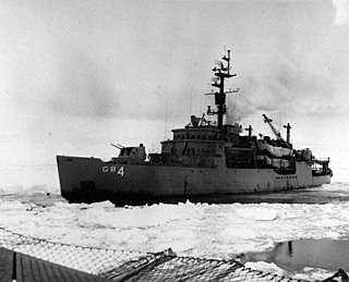
USS Glacier (AGB-4) was a U.S. Navy, then U.S. Coast Guard icebreaker which served in the first through fifteenth Operation Deep Freeze expeditions. Glacier was the first icebreaker to make her way through the frozen Bellingshausen Sea, and most of the topography in the area is named for her crew members. When built, Glacier had the largest capacity single armature DC motors ever installed on a ship. Glacier was capable of breaking ice up to 20 feet (6.1 m) thick, and of continuous breaking of 4-foot (1.2 m) thick ice at 3 knots.

Marble Point is a rocky promontory on the coast of Victoria Land, Antarctica. The United States operates a station at the point. The outpost is used as a helicopter refueling station supporting scientific research in the nearby continental interior, such as the McMurdo Dry Valleys. Dependent upon the weather conditions at the time, helicopters are able to fly in and out of the station 24 hours a day during the summer research season.

Cape Adare is a prominent cape of black basalt forming the northern tip of the Adare Peninsula and the north-easternmost extremity of Victoria Land, East Antarctica.

An ice pier or ice wharf is a man-made structure used to assist the unloading of ships in Antarctica. It is constructed by pumping seawater into a contained area and allowing the water to freeze. By repeating this procedure several times, additional layers are built up. The final structure is many metres in thickness, and strong enough to support container trucks. Operation Deep Freeze personnel constructed the first floating ice pier at Antarctica’s southernmost sea port at McMurdo Station in 1973. Ice piers have been in use each summer season since, at McMurdo's natural harbor at Winter Quarters Bay located at 77°50′S166°40′E. The harbor is positioned on the southern tip of Ross Island.

Maria Vasilyevna Klenova was a Russian and Soviet marine geologist and one of the founders of Russian marine science and contributor to the first Soviet Antarctic atlas.

Hut Point Peninsula is a long, narrow peninsula from 3 to 5 km wide and 24 km (15 mi) long, projecting south-west from the slopes of Mount Erebus on Ross Island, Antarctica. McMurdo Station (US) and Scott Base (NZ) are Antarctic research stations located on the Hut Point Peninsula.

Winter Quarters Bay is a small cove of McMurdo Sound, Antarctica, located 2,200 miles (3,500 km) due south of New Zealand at 77°50'S. The harbor is the southernmost port in the Southern Ocean and features a floating ice pier for summer cargo operations. The bay is approximately 250m wide and long, with a maximum depth of 33m. The name Winter Quarters Bay refers to Robert Falcon Scott's National Antarctic Discovery Expedition (1901–04) which wintered at the site for two seasons.
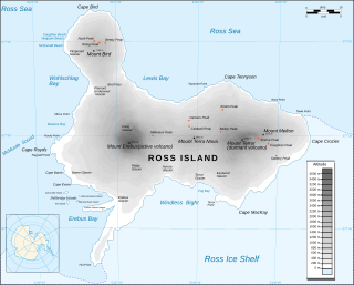
Cape Crozier is the most easterly point of Ross Island in Antarctica. It was discovered in 1841 during James Clark Ross's expedition of 1839 to 1843 with HMS Erebus and HMS Terror, and was named after Francis Crozier, captain of HMS Terror. The extinct volcano Mount Terror, also named during the Ross expedition, rises sharply from the Cape to a height of 3,230 m (10,600 ft), and the edge of the Ross Ice Shelf stretches away to its east.
The Kyle Hills are a prominent group of volcanic cones, hills, ridges, and peaks that occupy the eastern part of Ross Island, Antarctica, between Mount Terror and Cape Crozier. The hills extend east–west for 8 nautical miles (15 km), rising from sea level at Cape Crozier to about 2,600 metres (8,500 ft) in Mount McIntosh at the western end of the group. Local relief of features is on the order of 200 metres (660 ft).
Williamson Rock is a rock lying 4 nautical miles (7 km) northwest of Cape Crozier, close off the north coast of Ross Island. Charted by the British Antarctic Expedition, 1910–13, under Scott. Named for Thomas S. Williamson, who as able seaman and petty officer accompanied Scott's expeditions of 1901-04 and 1910–13.
Cape Wadworth is the northern extremity of Coulman Island, in the Ross Sea just off Victoria Land. Discovered 17 January 1841 by Sir James Clark Ross who named it to compliment his wife's uncle, Robert John Coulman of Wadworth Hall, Doncaster.
Cape Polar Star is a bold cape which forms the southwest extremity of Coulman Island in northwestern Ross Sea. Named by Advisory Committee on Antarctic Names (US-ACAN) in 1987 after USCGC activities in Antarctica, including the Ross Sea, since Operation Deep Freeze, 1978. A survey of this feature was conducted from Polar Star in 1986.

Seabee Hook is a low, recurved spit composed of coarse volcanic ash which projects about 900 m (984 yd) west from the high rocky ridge forming Cape Hallett, along the coast of Victoria Land. In January 1956, members of the US Navy's Operation Deep Freeze aboard the icebreaker USS Edisto investigated and surveyed this area for possible use as a base site for International Geophysical Year operations. Seabee is a phonetic spelling of CB and refers to individual or collective members of naval construction engineer units.
Lutz Hill is a hill rising to about 1,000 metres (3,300 ft) 1 nautical mile (2 km) southeast of The Tooth in the Kyle Hills of Ross Island, Antarctica. It was named by the Advisory Committee on Antarctic Names in 2000 after electrical engineer Larry F. Lutz of the Institute for Physical Science and Technology, University of Maryland, a specialist in the development of scientific research instrumentation for ground-based, balloon, and rocket sounding programs for the United States Antarctic Program. Lutz spent 17 summer seasons at McMurdo Station, South Pole Station, and Siple Station in the years 1980–2000.
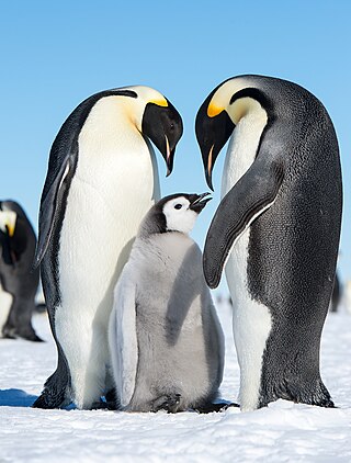
Ponganis Icefall is an icefall, 1,000 metres (3,300 ft) high and 1.25 nautical miles (2.32 km) wide on the east side of Coulman Island in the Ross Sea. The icefall descends from the Hawkes Heights caldera to the sea at Cape Main. It was named by the Advisory Committee on Antarctic Names in 2005 after Paul J. Ponganis, Center for Marine Biotechnology, Scripps Institution of Oceanography, who studied the behavior and census of Emperor penguins at Cape Crozier, Cape Washington, Beaufort Island, Franklin Island and Coulman Island in 13 field seasons, from 1987 to 2004, and for Katherine V. Ponganis, a member of the study team in five field seasons.
References
![]() This article incorporates public domain material from "Cape Polar Sea". Geographic Names Information System . United States Geological Survey.
This article incorporates public domain material from "Cape Polar Sea". Geographic Names Information System . United States Geological Survey.
| | This Borchgrevink Coast location article is a stub. You can help Wikipedia by expanding it. |