Capelas

Last updated • 3 min readFrom Wikipedia, The Free Encyclopedia
Capelas
Capelas, vista do Miradouro da Vigia da Baleia, Ponta Delgada, Acores.JPG
Capelas, as seen from the Vigia das Baleias Belvedere, along the northern coast of São Miguel Island
Locator map AZO SMG PDL Capelas.svg
Location of the civil parish of Capelas in the municipality of Ponta Delgada
Coordinates: 37°50′5″N25°41′51″W / 37.83472°N 25.69750°W / 37.83472; -25.69750
CountryFlag of Portugal.svg  Portugal
Auton. region Azores
Island São Miguel
Municipality Ponta Delgada
EstablishedSettlement: 12 February 1592
Parish: 3 July 1839
Area
  Total16.85 km2 (6.51 sq mi)
Elevation
130 m (430 ft)
Population
 (2011)
  Total4,080
  Density240/km2 (630/sq mi)
Time zone UTC−01:00 (AZOT)
  Summer (DST) UTC±00:00 (AZOST)
Postal code
9545-XXX
Area code 296
Patron Nossa Senhora da Apresentação

Capelas (Portuguese pronunciation: [kɐˈpɛlɐʃ] ; Portuguese for chapels ) is a civil parish along the northern coast of the municipality of Ponta Delgada, on the island of São Miguel in the Portuguese Azores. The population in 2011 was 4,080, [1] in an area of 16.85 square kilometres (6.51 sq mi). [2]

Contents

History

Parochial church of Nossa Senhora da Apresentacao in the main square, opposite the Polivalente (English: community center) Igreja de Nossa Senhora da Apresentacao, Fachada, Capelas, Ponta Delgada, ilha de Sao Miguel, Acores.JPG
Parochial church of Nossa Senhora da Apresentação in the main square, opposite the Polivalente (English: community center)

The first settlements congregated around the port of Poços, along the northern edge that divides Capelas from São Vicente Ferreira; its first settlers establishing shelters in and around the 16th Century. [3] With elevation of Capelas to (religious) parish it became integrated within the municipality of Ponta Delgada (on 11 July 1592). [3] This administrative dependency lasted until it was elevated to status of vila, as stipulated by the Carta de Lei (Charter Law) conferred by Queen D. Maria, on July 10, 1839.

There exists a couple of versions for Capela's toponymic origin. Father Gaspar Frutuoso in Saudades das Terras notes the following:

"Some say that they call it 'capelas', not because there existed in those parts churches or chapels, but that on the feast day of Saint John [the Baptist] some men constructed there some [small] chapels, forgetting them hung from a tree..."

Likewise, the brothers Bullar, in an account in their journeys, referred to a likely reality: they refer to a general local reference to the rocks along the coast as capelas, rocks taking on the appearance of small grottos and seeming to appear as chapels. [3]

Its main church, to the invocation of Nossa Senhora da Apresentação (Our Lady of the Presentation) was raised on the ruins of an older priory and concluded in 1780. Similarly, the church of Nossa Senhora da Conceição, built on the orders of Captain Agostinho de Medeiros Costa, in the 17th century, and reconstructed and expanded in 1830. Although Capelas may not have been named for the religious sanctuaries that were erected there, there are many to speak of, including the chapels of Anjo da Guarda, Santa Rita, Nossa Senhora do Rosário and Nossa Senhora de Santana, as well as many smaller hermitages to the invocation of the Holy Spirit.

During the whaling era in the Azores (early to middle 20th Century), Capelas was an important northern processing center on the island of São Miguel; close to the public pools around Poços is the ruins of the mixed-use factory used to process whale oil and mill flour. In Calhau Miúdo there existed two factories (Companhia Nova and Companhia Velha) to process whale byproducts during this period. [3]

Geography

View of the Morre of Capelas, along the northern coast, as seen from the outlook in Sao Vicente Ferreira Capelas' Morro.jpg
View of the Morre of Capelas, along the northern coast, as seen from the outlook in São Vicente Ferreira

Located along the northern coast, the parish has been connected to major centers by a series of roads linking the community to the city of Ponta Delgada (to the south), Mosteiros (to the west) and Ribeira Grande (to the east). Farmlands dominate the north and east portions of the parish, while the area from the E.R.1-1ª regional road towards the interior are dominated by mountains, river valleys and some ancient volcanic cones.

The administrative extent of Capelas incorporates the localities (Portuguese : lugares) of Teatro Novo, Conceição and Poços. [3]

Capelas has two small ports, one of which (known as "Poços") played a crucial role during centuries when Capelas was an important whaling center.

Culture

Festivities

On the fourth Sunday of August, the community celebrates the feast day of the parishes patron, Our Lady of the Presentation. Similar acts of faith are also expressed in the festivals of Corpo de Deus (Body of Christ) and Nossa Senhora de Lurdes (Our Lady of Lourdes). Apart from celebrating masses, a typical religious procession will wind through the roads in the parish, accompanied by the traditional philharmonic bands. [3]

Related Research Articles

<span title="Portuguese-language text"><i lang="pt">Vila do Porto</i></span> Municipality in Azores, Portugal

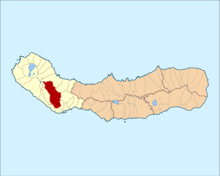
Vila do Porto is the single municipality, the name of the main town and one of the civil parishes on the island of Santa Maria, in the Portuguese archipelago of Azores. Its nearest neighbor, administratively, is the municipality of Povoação on the southern coast of São Miguel, and it is physically southwest of the islets of the Formigas. The population in 2021 was 5,408, in an area of 96.89 km2 (37.41 sq mi).

<span class="mw-page-title-main">Angra do Heroísmo</span> Municipality in Azores, Portugal

Angra do Heroísmo, or simply Angra, is a city and municipality on Terceira Island, Portugal, and one of the three capital cities of the Azores. Founded in 1478, Angra was historically the most important city in the Azores, as seat of the Bishop of the Azores, government entities, and having previously served as the capital city of Portugal during the Liberal Wars. The population in 2011 was 35,402, in an area of 239.00 km2. It was classified as a World Heritage site by UNESCO in 1983.

<span class="mw-page-title-main">Santa Cruz das Flores</span> Municipality in Azores, Portugal

Santa Cruz das Flores is a municipality situated in the north half of the island of Flores, in the Portuguese archipelago of the Azores. Situated in the sparsely populated Western Group, the population in 2021 was 2,020 inhabitants in an area that covers approximately 70.91 square kilometres (27.38 sq mi), bordering the southern municipality of Lajes das Flores.

<span class="mw-page-title-main">Conceição (Horta)</span> Civil parish in Azores, Portugal

Conceição is a freguesia in the municipality of Horta in the Portuguese Azores. The population in 2011 was 1,138, in an area of 3.08 km². It is the second smallest parish within the administration of Horta.

<span class="mw-page-title-main">Ajuda da Bretanha</span> Civil parish in Azores, Portugal

Ajuda da Bretanha is a northern civil parish in the municipality of Ponta Delgada, on the island of São Miguel in the Portuguese archipelago of the Azores. It is a relatively new parish, being elevated to this status when the former parish of Bretanha was divided, forming Ajuda and Pilar da Bretanha. The population in 2011 was 661, in an area of 7.09 km2. It contains the localities Ajuda da Bretanha, Amoreira and Lombinha.

<span class="mw-page-title-main">Arrifes</span> Civil parish in Ponta Delgada

Arrifes is a civil parish in the municipality of Ponta Delgada on the island of São Miguel in the Azores. The population in 2011 was 7,086, in an area of 25.37 km².

Covoada is a civil parish in the municipality of Ponta Delgada, on the island of São Miguel in the Azores. The population in 2011 was 1,341, in an area of 9.03 km2. It contains the localities Covoada, Nossa Senhora da Graça and Pavões.

<span class="mw-page-title-main">Fajã de Cima</span> Civil parish in Azores, Portugal

Fajã de Cima is a civil parish in the municipality of Ponta Delgada in the Portuguese archipelago of the Azores. Fajã de Cima is located in the Picos region in the western part of the island of São Miguel, north of central Ponta Delgada. The population in 2011 was 3,438, in an area of 11.89 km².

<span class="mw-page-title-main">Feteiras</span> Civil parish in Azores, Portugal

Feteiras is a civil parish in the municipality of Ponta Delgada in the Portuguese archipelago of the Azores. It is situated in the western part of the island of São Miguel, on the south coast. The population in 2011 was 1,571, in an area of 23.53 square kilometres (9.08 sq mi).

<span class="mw-page-title-main">Livramento (Ponta Delgada)</span> Civil parish in Azores, Portugal

Livramento is a civil parish in the municipality of Ponta Delgada in the Portuguese archipelago of the Azores. The population in 2011 was 4,062, in an area of 5.59 square kilometres (2.16 sq mi).

<span class="mw-page-title-main">Pilar da Bretanha</span> Civil parish in Azores, Portugal

Pilar da Bretanha is a civil parish in the municipality of Ponta Delgada on the island of São Miguel, in the Portuguese archipelago of the Azores. It was de-annexed from the historical parish of Bretanha on 10 July 2002, along with Ajuda da Bretanha. The population in 2011 was 624, in an area of 6.07 square kilometres (2.34 sq mi). It contains the localities Casa Telhada, Covas, João Bom and Pilar.

<span class="mw-page-title-main">Ribeira Grande, Azores</span> Municipality in Azores, Portugal

Ribeira Grande is a municipality in the northern part of the island of São Miguel in the Portuguese Azores. The population in 2011 was 32,112, in an area of 180.15 km2. The municipal seat is located in the civil parish of Matriz, with a population of about 4000 inhabitants, part of the urbanized core of what is commonly referred to as the city of Ribeira Grande.

<span class="mw-page-title-main">Fenais da Ajuda</span> Civil parish in Azores, Portugal

Fenais da Ajuda is a civil parish in the municipality of Ribeira Grande in the Portuguese archipelago of the Azores. The population in 2011 was 1,131, in an area of 13.36 km2.

<span class="mw-page-title-main">Povoação, Azores</span> Municipality in Azores, Portugal

Povoação is a municipality located in the southeastern corner of the island of São Miguel in the Portuguese archipelago of the Azores. The population in 2011 was 6,327, in an area of 106.41 km2.

<span class="mw-page-title-main">Furnas</span> Civil parish in Azores, Portugal

Furnas is a civil parish in the municipality of Povoação on the island of São Miguel in the Portuguese Azores. The population in 2011 was 1,439, in an area of 34.43 km2. The parish is one of the largest in the island and in the Azores. It is located east of Lagoa and Ponta Delgada, west of Povoação and southeast of Ribeira Grande.

<span class="mw-page-title-main">Achada</span> Civil parish in Azores, Portugal

Achada is a freguesia in the municipality Nordeste on the island of São Miguel in the Azores. The population in 2011 was 436, in an area of 11.89 km2.

<span class="mw-page-title-main">Vila do Porto (parish)</span> Civil parish in Azores, Portugal

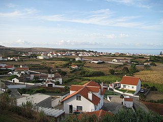
Vila do Porto is a civil parish in the municipality of Vila do Porto, located on the island of Santa Maria, in the Portuguese autonomous region of Azores. It is the southernmost and easternmost parish in the archipelago of Azores. The population in 2011 was 3,119, in an area of 25.55 km².

<span class="mw-page-title-main">Convent of Caloura</span> Convent in Lagoa, Portugal

The Convent of Caloura is a Portuguese 16th-century convent located in the civil parish of Água de Pau, in the municipality of Lagoa, on the island of São Miguel in the archipelago of the Azores.

<span class="mw-page-title-main">Church of Santa Cruz (Lagoa)</span> Church in Azores, Portugal

The Church of Santa Cruz is a Catholic church situated in the civil parish of Santa Cruz, in the municipality of Lagoa, in the Portuguese archipelago of the Azores.

References

Notes

Sources