Helsfyr-Sinsen was a borough of the city of Oslo, Norway up to January 1, 2004, when it was split and merged into Alna and Gamle Oslo boroughs. It consisted of the neighborhoods Helsfyr, Teisen, Etterstad, Keyserløkka, Lille Tøyen, Valle, Løren, Carl Berners plass, Rosenhoff and Sinsen.

Sinsen is a mixed residential and commercial area in Grünerløkka borough of Oslo, Norway. The westernmost part of Sinsen is part of the borough Nordre Aker.
The Grorud Line is a 13.0-kilometer long (8.1 mi) line on the Oslo Metro between Tøyen and Vestli in Oslo, Norway. Built as a mix of underground, at ground level and as an elevated line, it runs through the northern part of Groruddalen, serving such neighborhoods as Grorud, Romsås and Stovner. Line 5 runs along the entire line four times per hour. Line 4 runs between Vestli and Økern before branching off on the Løren Line to get onto the Ring Line. With 40,000 daily riders, the Grorud Line is the busiest branch of the metro.

The Sognsvann Line is a rapid transit line on the Oslo Metro of Norway. It branches from the Common Tunnel at Majorstuen and runs 6.0 kilometers (3.7 mi) to Sognsvann. After Ullevål stadion, the Ring Line branches off. The Sognsvann Line serves the northwestern and northern neighborhoods of Oslo, mostly within the borough of Nordre Aker. The line is owned and maintained by Kollektivtransportproduksjon and has nine stations. The western end of line 5 serves the entire line. Line 4 and the eastern end of line 5 serve the southern part of the line up to Ullevål stadion before branching off and continuing along the Ring Line. This gives an average five-minute headway on the southern part and an average fifteen-minute headway on the northern part of the line.

The Ring Line is the newest rapid transit loop line of the Oslo Metro of Oslo, Norway. It connects to the Sognsvann Line in the west and the Grorud Line in the east; along with these two lines and the Common Tunnel, the Ring Line creates a loop serving both the city centre and Nordre Aker borough. The 5.0 kilometres (3.1 mi)-long line has three stations: Nydalen, Storo and Sinsen. Four-fifths of the line runs within two tunnels, with the 1.0-kilometer (0.62 mi) section between Storo and Sinsen, including both stations, being the only at-grade part. The line connects to the Grorud Line north of Carl Berners plass and with the Sognsvann Line north of Ullevål stadion.

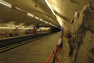
Carl Berners plass is an underground rapid transit station located on the Grorud Line of the Oslo Metro, and a tram stop on the Sinsen Line of the Oslo Tramway. The square also has a bus stop for lines 20, 21, 31 and 33. Located at Helsfyr in Oslo, Norway, the area has a mixture of apartment buildings and small businesses. The station is the first metro station on the Grorud Line after it branches off from the shared Common Tunnel. North of the station, the Ring Line branches off from the Grorud Line. The station is served by line 5 of the metro and Line 17 of the tramway, with four hourly departures during regular hours. The tram operates every 10 minutes during regular hours.
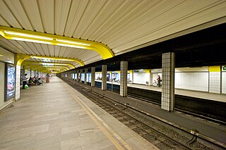
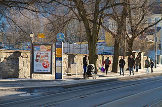
Sinsen is a rapid transit station on the Ring Line of the Oslo Metro. It is located at Sinsen in the Sagene borough of Oslo, Norway. Next to the station is the tram station Sinsenkrysset, that has been part of the Sinsen Line of the Oslo Tramway since 1939. The station opened on 20 August 2006, as part of the first section of the Ring Line. The station is served by line 4 and 5 of the metro, as well as several local bus services. Sinsen is a mixed residential and commercial area.
The Common Tunnel, sometimes called the Common Line, is a 7.3-kilometer (4.5 mi) long tunnel of the Oslo Metro which runs through the city center of Oslo, Norway. The name derives from the fact that all five lines of the metro use the tunnel, which runs from Majorstuen to Tøyen. The section has six stations, including the four busiest on the metro.

AS Oslo Sporveier is a defunct municipal owned company responsible for public transport in Oslo, Norway. It was created in 1924 to take over the city's two private tram companies. In 1927 its started with bus transport, including from 1940 to 1968 trolleybuses. Since 1966 rapid transit and from 1985 water buses have also been operated by the company. It was split into two separate companies in 2006; Kollektivtransportproduksjon took over the operation while Oslo Public Transport Administration was responsible for buying the services, fare regulation and marketing. The latter merged into Ruter in 2008, when the Oslo Sporveier brand was discontinued.

The Sagene Line is a former line of the Oslo Tramway in Norway. It ran from Stortorvet in the city center along Akersgata and Ullevålsveien through the neighborhood of St. Hanshaugen. It then continued along Colletts gate, Geitmyrsveien and Kierschouws gate to Sagene. At Sagene Church it had a regulation stop and access to Sagene Depot. The line continued along Bentsebrugata to Torshov, where it intersected with the Grünerløkka–Torshov Line.

The Løren Line is a 1.6-kilometer (1.0 mi) line of the Oslo Metro. Located entirely underground, it runs through the neighborhoods of Sinsen, Løren and Økern in Bjerke, creating a connection between the Ring Line with the Grorud Line. The line features one station, Løren. It is served by metro trains which run down the Grorud Line and then connect to the Ring Line. It allows for higher capacity on the metro as more passengers a transported via the Ring Line instead of through the congested Common Tunnel. Construction started in June 2013 and the line opened on 3 April 2016.

The Sinsen Line is part of the Oslo Tramway on the east side of the city. Most of the line is served by line 17, although the northernmost tip (Grefsen–Torshov) is served by line 18 which otherwise runs on the Grünerløkka–Torshov Line. Both services use SL95 articulated trams.

The Vika Line is a light rail section of the Oslo Tramway in Oslo, Norway. It runs between Wessels plass, through the neighborhood of Vika and Aker Brygge, before arriving at Solli. The section is served by SL79 trams on line 12. The line is owned by the municipal company Kollektivtransportproduksjon, and operated by its subsidiary Oslo Sporvognsdrift.

The history of the Oslo Tramway and Oslo Metro in Oslo, Norway, starts in 1875, when Kristiania Sporveisselskab (KSS) opened two horsecar lines through the city centre. In 1894, Kristiania Elektriske Sporvei (KES) built the first electric street tramways, which ran west from the city centre. Within six years, all tramways were electric. The city council established Kristiania Kommunale Sporveie (KKS) in 1899, which built three lines before it was sold to KSS six years later. Both KSS and KES were taken over by the municipality in 1924, becoming Oslo Sporveier. The company gradually expanded the city tram network, which reached its peak length in 1939.
St Halvards plass was a tram stop on the Gamleby Line of the Oslo Tramway. It was located at the square St Halvards plass, on the intersection of Oslo gate and Bispegata in Gamlebyen, Oslo, Norway.

Ring 2, sometimes called Kirkeveiringen and until 2010 officially known as National Road 161, and now also officially County road 161, is an important ring road and surface street through densely populated parts of Oslo, Norway.

The Rodeløkka Line is a former line of the Oslo Tramway of Norway. It was in use from 1900 to 1961, serving the neighborhood of Rodeløkka. After closing, the southern part of the line was designated as part of the Sinsen Line. The Rodeløkka Line was built by Kristiania Kommunale Sporveie (KKS) in 1900, and was subsequently taken over by Kristiania Sporveisselskab (KSS) in 1905. In 1924, the ownership was transferred to Oslo Sporveier. It was served by Line 9 until 1949, when it was replaced by a bus service. In 1955, a new route from Carl Berners plass to Rodeløkka was built, and the line was served by Line 13 until 1961, when the service was terminated. The tracks were removed between 1962 and 1964.

Schous plass is a square in the southern part of the borough of Grünerløkka in Oslo, Norway.
The Korsvoll Line is a former line of the Oslo Tramway in Norway. The line branched off from the Sagene Line at Bentsebrugata and ran along Bergensgata to Lisa Kristoffersens plass in Korsvoll, Oslo. The line opened on 1 May 1924 and was operated by Oslo Sporveier. From 1927 it became part of Line 10, which it remained part of until its closing on 17 January 1949. The reason for closing the line was that it was amongst the least trafficked lines of the tramway and Oslo Sporveier wanted to convert it to a trolleybus line.


