Bosanquet is a former township of Lambton County in Ontario, Canada located northeast of Sarnia.

Clinton is a community in the Canadian province of Ontario, located in the municipality of Central Huron. Clinton was established in 1831, when Jonas Gibbings and brothers Peter and Stephen Vanderburg cleared out a small area to start. Clinton started to grow in 1844 when William Rattenbury laid out the plans to begin making a village. In 1954, Clinton's population was 2,625 people. Today, it has an estimated population of 3,203.
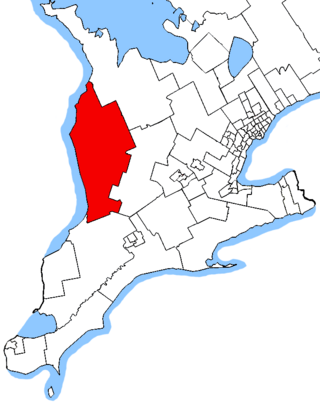
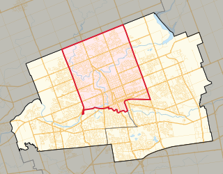
Huron—Bruce is a federal electoral district in Ontario, Canada, that has been represented in the House of Commons of Canada since 1953.

Perth—Wellington is a federal electoral district in southwestern Ontario, Canada, that has been represented in the House of Commons of Canada since 2004. The riding consists of:
Perth—Wellington—Waterloo was a federal electoral district represented in the House of Commons of Canada from 1988 to 1997. It was located in the province of Ontario. This riding was created in 1987 from parts of Perth, Waterloo and Wellington—Dufferin—Simcoe ridings.

Listowel is an unincorporated community in Ontario, Canada, located in the Municipality of North Perth. Incorporated as the Town of Listowel in 1875, it was dissolved in 1998 following amalgamation with several other communities in the northern section of Perth County. Its population was 9,539 at the Canada 2021 Census in a land area of 6.73 square kilometres; at the time there were 3,910 occupied dwellings.
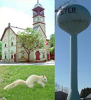
Exeter is a community in the municipality of South Huron, in the southern portion of Huron County, Ontario, Canada, located approximately 40 kilometres north of London. The community proclaims itself the "Home of the White Squirrel", owing to the presence of the unusually-coloured mammals. Exeter's mascot, "Willis The White Wonder", can be seen at many community events throughout the year, including Canada Day celebrations, the Exeter Rodeo, and the Santa Claus Parade.

Goderich Airport, also known as Goderich Municipal Airport, is a registered aerodrome located 1.5 nautical miles north of Goderich, Ontario, Canada.

Hensall is a community in Bluewater, Ontario, Canada with a population of 1,173. It is located in the centre of Huron County's agricultural land, and is home to three large processing facilities: Thompsons Limited, Hensall Co-op and Cook's Division of Parrish & Heimbecker Ltd., where thousands of tons of beans are annually processed, packaged and shipped worldwide.
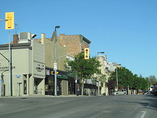
Mitchell is a community in the municipality of West Perth, part of Perth County, Ontario, Canada. It is located at the intersection of Ontario Highways 8 and 23, 20 kilometres (12 mi) northwest of Stratford, and 60 kilometres (37 mi) north of London. Mitchell is no longer a separate entity. On January 1, 1998, the town amalgamated with the neighbouring Townships of Logan, Fullarton, and Hibbert to form the new Municipality of West Perth. As of 2016, the former town of Mitchell has a population of 4,573 in a land area of 4.81 square kilometres (1.86 sq mi); it has 1,827 occupied private dwellings.

The Township of Ashfield–Colborne–Wawanosh is a municipality in Huron County, Ontario, Canada. It was formed as an amalgamation of the former Ashfield, Colborne and West Wawanosh townships in 2001, in an Ontario-wide local government restructuring imposed by the government of that time. The three former townships now comprise the wards of the amalgamated municipality. Mayor of Dungannon Robert Brindley Jr.
Norm Aldridge Field is a municipally owned, natural-grass baseball diamond in Stronach Park in northeast London, Ontario, that was built as a secondary baseball venue for the 2001 Canada Summer Games and named by London city council after longtime London sportsman/ athlete, Norman James Aldridge, on September 5, 2000.
Carlingford is a Canadian rural community in Victoria County, New Brunswick, on the Canada–United States border between Maine and New Brunswick. Carlingford is midway between Perth-Andover and Fort Fairfield on Route 190, also known as the Fort Road, which ends at the Canada Border Services Agency inspection station.
Brunner is a community in the Township of Perth East, Perth County, Ontario, Canada. It lies 17 kilometres (11 mi) north of Stratford on Perth County Road 119. Topping is the nearest community, 4 kilometres (2 mi) east, and Milverton is 5 kilometres (3 mi) north. The Stratford and Huron Railway, later part of Canadian National Railway, passes through the community.
Carthage is a community in the Township of Perth East, Perth County, Ontario, Canada. It lies 12 kilometres (7 mi) north of Milverton on Perth County Road 119 at 83rd Line. Tralee is the nearest community, 2.7 kilometres (1.7 mi) north, Burns is 3.4 kilometres (2.1 mi) south, and Hesson is 5.6 kilometres (3.5 mi) east. Smith Creek passes through the community.
Whitechurch is a small residential village located in south-western Ontario.
Perth—Wellington is a provincial electoral district in Ontario, Canada, that has been represented in the Legislative Assembly of Ontario since the 2007 provincial election.
London North Centre is an electoral district in the province of Ontario, Canada, that has been represented in the Legislative Assembly of Ontario since 1999. London North Centre was created from London North to match the federal riding in 1996.
King's Highway 43, also known as Highway 43, was a provincially maintained highway in the Canadian province of Ontario. On January 1, 1998, the entire route was transferred to the county that each section resided in, resulting in the current designations of Lanark County Road 43, Leeds and Grenville Road 43 and Stormont, Dundas and Glengarry Road 43. Highway 43 ran somewhat parallel to and between Highway 401 and Highway 417 from Highway 7 in Perth to Highway 34 in Alexandria, passing through several small towns along the way. At 154.2 km (95.8 mi), it is the longest highway in Ontario to be decommissioned entirely during the mass transfer of Highways in 1997 and 1998.
Walworth is a hamlet in the Town of Walworth, Wayne County, New York, United States. It is located in the southeastern corner of the town, six miles (10 km) north-northeast of the hamlet of Macedon, at an elevation of 541 feet. The primary cross roads where the hamlet is located are Penfield-Walworth Road, Walworth-Marion Road, Walworth-Ontario Road and Walworth Road. N.Y. Route 350 passes just west of Walworth. Government offices for the Town of Walworth are located in the hamlet.
