
The term intraplate earthquake refers to a variety of earthquake that occurs within the interior of a tectonic plate; this stands in contrast to an interplate earthquake, which occurs at the boundary of a tectonic plate. Intraplate earthquakes are often called "intraslab earthquakes," especially when occurring in microplates.

The Explorer Plate is an oceanic tectonic plate beneath the Pacific Ocean off the west coast of Vancouver Island, Canada, which is partially subducted under the North American Plate. Along with the Juan de Fuca Plate and Gorda Plate, the Explorer Plate is a remnant of the ancient Farallon Plate, which has been subducted under the North American Plate. The Explorer Plate separated from the Juan de Fuca Plate roughly 4 million years ago. In its smoother, southern half, the average depth of the Explorer plate is roughly 2,400 metres (7,900 ft) and rises up in its northern half to a highly variable basin between 1,400 metres (4,600 ft) and 2,200 metres (7,200 ft) in depth.

In geology, aseismic creep or fault creep is measurable surface displacement along a fault in the absence of notable earthquakes. Aseismic creep may also occur as "after-slip" days to years after an earthquake. Notable examples of aseismic slip include faults in California.
A slow earthquake is a discontinuous, earthquake-like event that releases energy over a period of hours to months, rather than the seconds to minutes characteristic of a typical earthquake. First detected using long term strain measurements, most slow earthquakes now appear to be accompanied by fluid flow and related tremor, which can be detected and approximately located using seismometer data filtered appropriately. That is, they are quiet compared to a regular earthquake, but not "silent" as described in the past.

The Liquiñe-Ofqui Fault is major geological fault that runs a length of roughly 1,200 kilometres (750 mi) in a NNE-SSW orientation and exhibits current seismicity. It is located in the Chilean Northern Patagonian Andes. It is a dextral intra-arc strike-slip fault. Most large stratovolcanoes of the Southern Volcanic Zone of the Andes are aligned by the fault which allows for the movement of magma and hydrothermal fluids.
Earthquake forecasting is a branch of the science of seismology concerned with the probabilistic assessment of general earthquake seismic hazard, including the frequency and magnitude of damaging earthquakes in a given area over years or decades. While forecasting is usually considered to be a type of prediction, earthquake forecasting is often differentiated from earthquake prediction, whose goal is the specification of the time, location, and magnitude of future earthquakes with sufficient precision that a warning can be issued. Both forecasting and prediction of earthquakes are distinguished from earthquake warning systems, which, upon detection of an earthquake, provide a real-time warning to regions that might be affected.
Episodic tremor and slip (ETS) is a seismological phenomenon observed in some subduction zones that is characterized by non-earthquake seismic rumbling, or tremor, and slow slip along the plate interface. Slow slip events are distinguished from earthquakes by their propagation speed and focus. In slow slip events, there is an apparent reversal of crustal motion, although the fault motion remains consistent with the direction of subduction. ETS events themselves are imperceptible to human beings and do not cause damage.
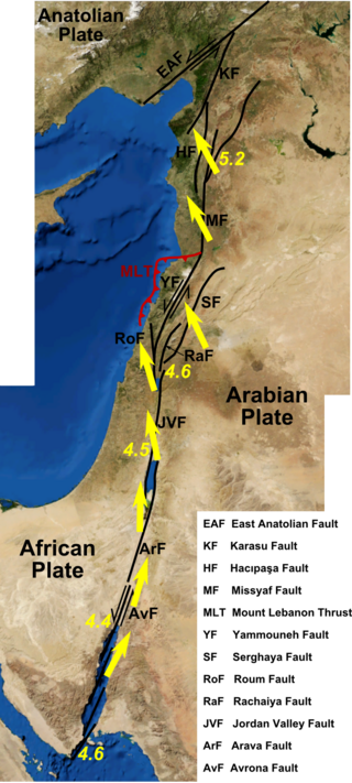
The Dead Sea Transform (DST) fault system, also sometimes referred to as the Dead Sea Rift, is a series of faults that run for about 1,000 km from the Maras Triple Junction to the northern end of the Red Sea Rift. The fault system forms the transform boundary between the African Plate to the west and the Arabian Plate to the east. It is a zone of left lateral displacement, signifying the relative motions of the two plates. Both plates are moving in a general north-northeast direction, but the Arabian Plate is moving faster, resulting in the observed left lateral motions along the fault of approximately 107 km at its southern end. A component of extension is also present in the southern part of the transform, which has contributed to a series of depressions, or pull-apart basins, forming the Gulf of Aqaba, Dead Sea, Sea of Galilee, and Hula basins. A component of shortening affects the Lebanon restraining bend, leading to uplift on both sides of the Beqaa valley. There is local transtension in the northernmost part of the fault system, forming the Ghab pull-apart basin.
The Chixoy-Polochic Fault, also known as Cuilco-Chixoy-Polochic Fault, is a major fault zone in Guatemala and southeast Mexico. It runs in a light arc from the east coast of Guatemala to Chiapas, following the deep valleys of the Polochic River, Chixoy River and Cuilco River.
The East Greenland orogen, also known as East Greenland mountain range, is the linear mountain range along the eastern Greenland coast, from 70 to 82 degrees north latitude.
The Greenland Plate is a supposed tectonic plate bounded to the west by Nares Strait, a probable transform fault; on the southwest by the Ungava transform underlying Davis Strait; on the southeast by the Mid-Atlantic Ridge; and the northeast by the Gakkel Ridge, with its northwest border still being explored. The Greenland craton is made up of some of the oldest rocks on Earth. The Isua greenstone belt in southwestern Greenland contains the oldest known rocks on Earth dated at 3.7–3.8 billion years old.

The Tacoma Fault, just north of the city of Tacoma, Washington, is an active east–west striking north dipping reverse fault with approximately 35 miles (56 km) of identified surface rupture. It is believed capable of generating earthquakes of at least magnitude Mw 7, and there is evidence of such a quake approximately 1,000 years ago, possibly the same earthquake documented on the Seattle Fault 24 miles (38 km) to the north.
Susan Y. Schwartz is a scientist at the University of California, Santa Cruz known for her research on earthquakes, through field projects conducted in locations in Costa Rica and the San Andreas Fault.

The Trans-European Suture Zone (TESZ), also known as the Tornquist Zone, is the crustal boundary between the Precambrian East European Craton and the Phanerozoic orogens of South-Western Europe. The zone runs from the North Sea to the Black Sea. The north-western part of the zone was created by the collision of Avalonia and Baltica/East European Craton in the Late Ordovician. The south-eastern part of the zone, now largely concealed by deep sedimentary basins, developed through Variscan and Alpine orogenic events.
The 1956 Amorgos earthquake occurred at 03:11 UTC on July 9. It had a magnitude of 7.7 on the moment magnitude scale and a maximum perceived intensity of IX on the Mercalli intensity scale. The epicentre was to the south of the island of Amorgos, the easternmost island of the Cyclades in the Aegean Sea. There was significant damage on Amorgos and the neighbouring island of Santorini. It was the largest earthquake in Greece in the 20th century. It was followed 13 minutes later by a magnitude 7.2 earthquake near Santorini. It triggered a major tsunami with a maximum run-up of 30 m. The combined effects of the earthquake shaking and the tsunami caused the deaths of 53 people with a further 100 injured.

The Canadian Arctic Rift System is a major North American geological structure extending from the Labrador Sea in the southeast through Davis Strait, Baffin Bay and the Arctic Archipelago in the northwest. It consists of a series of interconnected rifts that formed during the Paleozoic, Mesozoic and Cenozoic eras. Extensional stresses along the entire length of the rift system have resulted in a variety of tectonic features, including grabens, half-grabens, basins and faults.
Hans Thybo is a Danish geophysicist and geologist. He was a Professor of Geophysics at the Geological Institute and the Institute for Geography and Geology at the University of Copenhagen, as well as at the Centre for Earth Evolution and Dynamics. at University of Oslo. He is a professor at the Eurasia Institute of Earth Sciences at Istanbul Technical University and at the School of Earth Sciences at China University of Geosciences, Wuhan. Until a fusion in 2007 he was elected Head of Department at the Geological Institute and member of the board of Geocenter Copenhagen. He was Professor at Department of Geosciences and Natural Resource Management until he was dismissed from his Chair in 2016. The dismissal was later found illegal and violating employment agreements by an arbitration court and Thybo received a modest economic compensation, but the University of Copenhagen did not re-employ Thybo, nor did the University sanction his accusers. The internationally agreed principle of tenure for university professors does not apply to universities in Denmark. Thybo has earlier been associated with Technische Hogeschool Delft and Stanford University.
Anne M. Tréhu is a professor at Oregon State University known for her research on geodynamic processes, especially along plate boundaries. She is an elected fellow of the American Geophysical Union.

Oblique subduction is a form of subduction for which the convergence direction differs from 90° to the plate boundary. Most convergent boundaries involve oblique subduction, particularly in the Ring of Fire including the Ryukyu, Aleutian, Central America and Chile subduction zones. In general, the obliquity angle is between 15° and 30°. Subduction zones with high obliquity angles include Sunda trench and Ryukyu arc.
