Related Research Articles
The Geography of Guyana comprises the physical characteristics of the country in Northern South America and part of Caribbean South America, bordering the North Atlantic Ocean, between Suriname and Venezuela, with a land area of approximately 214,969 square km. The country is situated between 1 and 9 north latitude and between 56 and 62 west longitude. With a 459 km (285 mi)-long Atlantic coastline on the northeast, Guyana is bounded by Venezuela on the west, Brazil on the west and south, and Suriname on the east.

The Gulf of St. Lawrence is the outlet of the North American Great Lakes via the St. Lawrence River into the Atlantic Ocean. The gulf is a semi-enclosed sea, covering an area of about 226,000 square kilometres (87,000 sq mi) and containing about 34,500 cubic kilometres (8,300 cu mi) of water, at an average depth of 152 metres (500 ft).

The Arctic Archipelago, also known as the Canadian Arctic Archipelago, is an archipelago lying to the north of the Canadian continental mainland, excluding Greenland and Iceland.

Polk Township is a township in Jefferson County, Pennsylvania, United States. The population was 282 at the 2020 census. It was named for President James K. Polk.
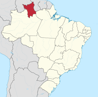
Roraima is one of the 26 states of Brazil. Located in the country's North Region, it is the northernmost and most geographically and logistically isolated state in Brazil. It is bordered by the state of Pará to the southeast, Amazonas to the south and west, Venezuela to the north and northwest, and Guyana to the east.
Mount Roraima is the highest of the Pakaraima chain of tepuis or plateaux in South America. It is located at the junction of Venezuela, Brazil and Guyana. A characteristic large flat-topped mountain surrounded by cliffs 400 to 1,000 meters high. The highest point of Mount Roraima is located on the southern edge of the cliff at an altitude of 2,810 meters in Venezuela, and another protrusion at an altitude of 2,772 meters at the junction of the three countries in the north of the plateau is the highest point in Guyana. The name of Mount Roraima came from the native Pemon people. Roroi in the Pemon language means "blue-green", and ma means "great".

Classification of Indigenous peoples of the Americas is based upon cultural regions, geography, and linguistics. Anthropologists have named various cultural regions, with fluid boundaries, that are generally agreed upon with some variation. These cultural regions are broadly based upon the locations of Indigenous peoples of the Americas from early European and African contact beginning in the late 15th century. When Indigenous peoples have been forcibly removed by nation-states, they retain their original geographic classification. Some groups span multiple cultural regions.

Caxambu is a Brazilian municipality in Minas Gerais. Its population in 2021 was estimated at 21,566.
The Pacaraima or Pakaraima Mountains are a mountain range primarily in southwestern Guyana, and into northern Brazil and eastern Venezuela.

The Ireng River forms part of Guyana's western border with Brazil. It flows through the valleys of the Pakaraima Mountains for most of its length. It is the only major river in Guyana which flows from North to South, up to its confluence into the Takutu River. It is one of the northernmost tributaries of the Amazon river system.
The Orinduik Falls lie on the Ireng River, a highland river that thunders over steps and terraces of red jasper on the border of Guyana and Brazil before merging with the Takutu River and into Brazil to join the Amazon River.
The Miang River is a river of Roraima state in northern Brazil.
The Paricarana River is a river of Roraima state in northern Brazil.
The Uatatas River is a river of Roraima state in northern Brazil.
The Ailã River is a river of Roraima state in northern Brazil. It is located in Monte Caburaí, in the municipality of Uiramutã. Its source is the northernmost point of Brazil.

The Ebe W. Tunnell was a 19th-century Delaware pilot schooner built in 1887 in Brooklyn, New York. In 1889, the Tunnell was driven out to sea in a fierce storm. The crew spent five days in turbulent waters before they were rescued. In the age of steam, Ebe W. Tunnell had outlived its usefulness and was sold as a houseboat for a group of men working in the Chesapeake Bay in 1909.
References
- ↑ "Mapa Rodoviário Roraima" (PDF). Brazilian Ministry of Transport (Departmento Nacional de Infra-estrutura de Transportes). 2002.. The bulk of the Rio Caroaebe is located to the northeast of the map-coordinate at 01°00′N60°00′W / 1.000°N 60.000°W indicated by the map-grid.
- ↑ James L. Crainey; Aline Mattos-Glória; Neusa Hamada; Sérgio L. B. Luz (November 4, 2013). "New tools and insights to assist with the molecular identification of Simulium guianense s.l., main Onchocerca volvulus vector within the highland areas of the Amazonia onchocerciasis focus" . Acta Tropica . 131: 49, 51. doi:10.1016/j.actatropica.2013.10.019. PMID 24200838 – via ResearchGate.
- ... [page 49] Collection site locality: Roraima, São João da Baliza, Rio Caro[a]ebe[ sic?], Vicinal 32(GR), 01°02′N59°55′W / 1.033°N 59.917°W . Collection date: 28.ix.2005. Collector: A.M. Collected specimens: S. guianense(4). Ecology: Forest-dwelling. Molecular markers: CO1(4) ITS(4). ... [page 51] Sequence: Rib-GR1. Source specimen: S. guianense Roraima (Caro[a]ebe)#1. ITS-1 diagnosed intragenomic SNPs: SNP-47 (T/G); SNP-99 (A/C); SNP-101 (C/T). ITS-2 diagnosed intragenomic SNPs: SNP-485 (A/G). Sequence: Rib-GR2. Source specimen: S. guianense Roraima (Caro[a]ebe)#2....