
Yorkshire is an area of Northern England which was historically a county. Despite no longer being used for administration, Yorkshire retains a strong regional identity. The county was named after its county town, the city of York.

West Yorkshire is a metropolitan and ceremonial county in the Yorkshire and the Humber region of England. It borders North Yorkshire to the north and east, South Yorkshire and Derbyshire to the south, Greater Manchester to the south-west, and Lancashire to the west. The city of Leeds is the largest settlement.

Wakefield is a cathedral city in West Yorkshire, England located on the River Calder. The city had a population of 109,766 in the 2021 census, up from 99,251 in the 2011 census. The city is the administrative centre of the wider Metropolitan Borough of Wakefield, which had a 2022 population of 357,729, the 26th most populous district in England. It is part of the West Yorkshire Built-up Area and the Yorkshire and The Humber region.

Ledsham is a village and civil parish 4 miles (6 km) north of Castleford and 11 miles (18 km) east of Leeds in the county of West Yorkshire, England. The village is in the City of Leeds metropolitan borough and near to the A1(M) motorway. It had a population of 162 at the 2001 Census, increasing to 181 at the 2011 Census.

The West Riding of Yorkshire is one of three historic subdivisions of Yorkshire, England. From 1889 to 1974 the riding was an administrative county named County of York, West Riding. The lieutenancy at that time included the city of York and as such was named "West Riding of the County of York and the County of the City of York". The riding ceased to be used for administrative purposes in 1974, when England's local government was reformed.

Horbury is a town in the City of Wakefield in West Yorkshire, England. Historically in the West Riding of Yorkshire, it is situated north of the River Calder about three miles (5 km) south west of Wakefield and two miles (3 km) to the south of Ossett. It includes the outlying areas of Horbury Bridge and Horbury Junction. At the 2001 census the Horbury and South Ossett ward of Wakefield Metropolitan District Council had a population of 10,002. At the 2011 census the population was 15,032. Old industries include woollens, engineering and building wagons for the railways. Horbury forms part of the Heavy Woollen District.

Wakefield, also known as the City of Wakefield, is a local government district with city status and a metropolitan borough in West Yorkshire, England. Wakefield, the largest settlement, is the administrative centre of the district. The population of the City of Wakefield at the 2011 Census was 325,837.

Wakefield was a constituency in West Yorkshire, England. It was created as a borough constituency in 1832 and reformed as a county constituency in 1885.
The English ceremonial county of West Yorkshire is divided into 24 parliamentary constituencies: 12 borough constituencies and 12 county constituencies, two of which are partly in North Yorkshire.

John Carr (1723–1807) was a prolific English architect, best known for Buxton Crescent in Derbyshire and Harewood House in West Yorkshire. Much of his work was in the Palladian style. In his day he was considered to be the leading architect in the north of England.

West Yorkshire Police, formerly the West Yorkshire Metropolitan Police, is the territorial police force responsible for policing the metropolitan county of West Yorkshire, England. It is the fourth largest territorial police force in England and Wales by number of officers.
Escrick is a village and civil parish in North Yorkshire, England. It was in the historic East Riding of Yorkshire, but since 1974 has come under North Yorkshire. It is approximately equidistant between Selby and York on what is now the A19 road.

Shepley is a village in the civil parish of Kirkburton, in Kirklees, West Yorkshire, England. It lies 8 miles (13 km) south south east of Huddersfield and 6 miles (9.7 km) north west of Penistone.
Upton is a village in the civil parish of Upton and North Elmsall, in the City of Wakefield, West Yorkshire, England. The parish had a population of 3,541 in the 2001 census.

Kellington is a small village and civil parish in the Selby District of North Yorkshire, England, on the banks of the River Aire. Situated almost equidistant between the towns of Pontefract and Selby, the village dates back to at least the 11th century when it was listed in the Domesday Book. The semi-rural community grew in size with the advent of local mining as housing was built to accommodate the workers of nearby Kellingley Colliery.
Flags and symbols of Yorkshire have been used to identify Yorkshire and its related councils through flags and symbols. This article also includes flags and symbols used by the present and former local authorities covering Yorkshire.
East Hardwick is a village and civil parish in the City of Wakefield in West Yorkshire, England. It has a population of 191, reducing to 173 at the 2011 Census. Until 1974 it was part of Osgoldcross Rural District.

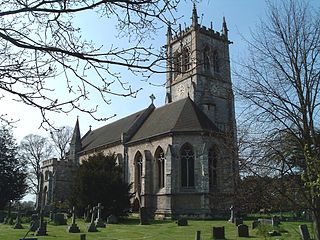
Warmfield cum Heath is a civil parish in the City of Wakefield in West Yorkshire, England. The parish lies just over 1-mile (1.6 km) east of Wakefield, and has 57 listed buildings within the parish boundaries.

Wakefield Council, also known as the City of Wakefield Metropolitan District Council, is the local authority of the City of Wakefield in West Yorkshire, England. Wakefield has had a council since 1848, which has been reformed on several occasions. Since 1974 it has been a metropolitan borough council. It provides the majority of local government services in the city. The council has been a member of the West Yorkshire Combined Authority since 2014.

