
Granite is a coarse-grained (phaneritic) intrusive igneous rock composed mostly of quartz, alkali feldspar, and plagioclase. It forms from magma with a high content of silica and alkali metal oxides that slowly cools and solidifies underground. It is common in the continental crust of Earth, where it is found in igneous intrusions. These range in size from dikes only a few centimeters across to batholiths exposed over hundreds of square kilometers.

Cobblestone is a natural building material based on cobble-sized stones, and is used for pavement roads, streets, and buildings.
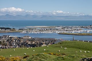
Pwllheli is a market town and community of the Llŷn Peninsula in Gwynedd, north-western Wales. It had a population of 4,076 in 2011 of whom a large proportion, 81%, are Welsh speaking. Pwllheli is the place where Plaid Cymru was founded. It is the birthplace of the Welsh poet Sir Albert Evans-Jones.

Siljan, in Dalarna in central Sweden, is Sweden's seventh largest lake. The cumulative area of Siljan and the adjacent, smaller lakes Orsasjön and Insjön is 354 km2 (137 sq mi). Siljan reaches a maximum depth of 134 m (440 ft), and its surface is situated 161 m (528 ft) above sea level. This renders the lowest point of the basin at 27 metres (89 ft) above sea level. The largest town on its shore is Mora.

Bluestone is a cultural or commercial name for a number of dimension or building stone varieties, including:

Diabase, also called dolerite or microgabbro, is a mafic, holocrystalline, subvolcanic rock equivalent to volcanic basalt or plutonic gabbro. Diabase dikes and sills are typically shallow intrusive bodies and often exhibit fine-grained to aphanitic chilled margins which may contain tachylite.
Mynydd Tir y Cwmwd is an area of about 175 acres in north Wales to the south of the village of Llanbedrog.

Pemulwuy is a suburb in Greater Western Sydney, in the state of New South Wales, Australia. Pemulwuy is located 30 kilometres west of the Sydney central business district in the local government area of the Cumberland Council. Pemulwuy is home to the highest point between the Blue Mountains and Sydney, the summit of Prospect Hill.
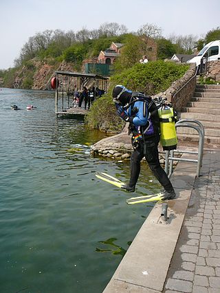
Stoney Cove is a large flooded quarry which is a popular inland scuba diving site, located between Stoney Stanton and Broughton Astley in Leicestershire, England.

The Cliffe Hill Mineral Railway was a 2 ft narrow gauge industrial railway that connected the Cliffe Hill granite quarry to the nearby London Midland and Scottish Railway (LMS) between Leicester and Coalville. The line opened in 1896 and operated until 1948.

The Penmaenmawr & Welsh Granite Co. owned and operated a major granite quarry on the north Wales coast located between Conwy and Llanfairfechan. Granite axe-heads and other implements from Neolithic quarries at Penmaenmawr have been found throughout Britain.

The Haytor Granite Tramway was a tramway built to convey granite from Haytor Down, Dartmoor, Devon to the Stover Canal. It was very unusual in that the track was formed of granite sections, shaped to guide the wheels of horse-drawn wagons.

Nant Gwrtheyrn is a Welsh Language and Heritage Centre, located near the village of Llithfaen on the northern coast of the Llŷn Peninsula, Gwynedd, in northwest Wales.
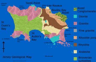
The geology of Jersey is characterised by the Late Proterozoic Brioverian volcanics, the Cadomian Orogeny, and only small signs of later deposits from the Cambrian and Quaternary periods. The kind of rocks go from conglomerate to shale, volcanic, intrusive and plutonic igneous rocks of many compositions, and metamorphic rocks as well, thus including most major types.

Statham's Quarry is the site of a quarry on the Darling Scarp on the southern side of the entrance of the Helena River valley on to the Swan Coastal Plain in Perth, Western Australia. It is located in Gooseberry Hill and is within the bounds of the Gooseberry Hill National Park.

A sett, also known as a block or Belgian block, is a broadly rectangular quarried stone used in paving roads and walkways. Formerly in widespread use, particularly on steeper streets because setts provided horses' hooves with better grip than a smooth surface, they are now encountered rather as decorative stone paving in landscape architecture. Setts are often referred to as "cobblestones", although a sett is distinct from a cobblestone in that it is quarried or worked to a regular shape, whereas the latter is generally a small, naturally-rounded rock. Setts are usually made of granite.
Stanner Rocks is a rounded hill, steep in parts, which lies close to the Wales border with England between Walton and Kington. A superb collection of wild plants can be found here. Where it faces south, warm sunshine and drying winds create an ideal environment for plants which are more likely to be seen around the Mediterranean. The most famous of Stanner Rocks’ specialties is the pretty and elusive Radnor Lily, having small, starry yellow flowers.

Trencrom Hill is a prominent hill fort, owned by the National Trust, near Lelant, Cornwall. It is crowned by an univallate Neolithic tor enclosure and was re-used as a hillfort in the Iron Age. Cairns or hut circles can be seen in the level area enclosed by the stone and earth banks. The hill overlooks the Hayle Estuary and river, and Mount's Bay and St Michael's Mount can be seen to the south. The hill was recorded as Torcrobm in 1758 which is derived from Cornish "torr crobm", i.e. 'hunched bulge'.

Barrow Hill Local Nature Reserve is a local nature reserve situated in Pensnett in the county of West Midlands, England. Its most distinctive feature, Barrow Hill, is the eroded remnant of a high level igneous intrusion that was formed 315 million years ago during the Carboniferous period. The reserve was created in 2005.
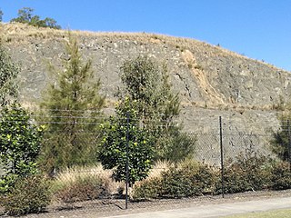
The Prospect dolerite intrusion, or Prospect intrusion, is a Jurassic picrite or dolerite laccolith that is situated in Sydney, New South Wales, Australia. Lying in the heart of Cumberland Plain, in the suburb of Pemulwuy, the intrusion is Sydney's largest body of igneous rock, rising to a height of 117 metres (384 ft) above sea level. The site is formed by an intrusion of dolerite rock into Ashfield Shale. At least seven different rock types occur in the intrusion.

