
The Barcelona Metro is a network of rapid transit electrified railway lines that run mostly underground in central Barcelona and into the city's suburbs. It is part of the larger public transport system of Barcelona, the capital of Catalonia, Spain, with unified fares under the Autoritat del Transport Metropolità (ATM) scheme. As of 2014, the network is operated by two separate companies: Transports Metropolitans de Barcelona (TMB) and Ferrocarrils de la Generalitat de Catalunya (FGC). It is made up of 12 lines, combining the lines owned by the two companies. Two lines, L9 and L10, are being built at present, with both lines having different sections of each opened between 2009 and 2018. They are due to be fully completed in 2026. Three lines on the network have opened as automatic train operation/driverless vehicle systems since 2009: Line 11 being converted to driverless first, and then Lines 9 and 10, opening up driverless.
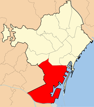
Sants-Montjuïc is one of the ten districts into which Barcelona has been split since 1984, numbered District 3. Comprising very different areas of the city, it covers the southern part of Barcelona, joining the two former districts II and VII, as well as the different areas comprised in the Zona Franca. As of the 2005, census it had a population of 177,636. It borders Les Corts, Eixample, Ciutat Vella, and the municipalities L'Hospitalet de Llobregat and El Prat de Llobregat.
The Plaça d'Urquinaona is one of the principal squares in central Barcelona. It is officially part of Dreta de l'Eixample neighbourhood, in the Eixample district, and is located at the intersection of the Ronda Sant Pere and Carrer d'Ausiàs Marc.

Passeig de Sant Joan is a major avenue in the Eixample and Gràcia districts of Barcelona. It was named after an older street carrying this name, also known as Passeig Nou, built in 1795 around the glacis of the Ciutadella fortress.

Sants is a neighbourhood in the southern part of Barcelona. It belongs to the district of Sants-Montjuïc and is bordered by the districts of Eixample to the northeast, Les Corts to the northwest, and by the municipality of l'Hospitalet de Llobregat to the south. Although old-fashioned, its name is sometimes still written as Sans in some Spanish-language sources.

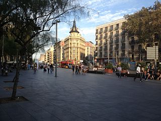
Plaça d'Espanya is one of Barcelona's most important squares, built on the occasion of the 1929 Barcelona International Exposition, held at the foot of Montjuïc, in the Sants-Montjuïc district.

Avinguda Meridiana is a major avenue in Barcelona, Catalonia, Spain, spanning parts of the Sant Andreu, Nou Barris and Sant Martí northern districts of the city. Originally planned by Ildefons Cerdà in 1859 to be one of the two most important thoroughfares in Barcelona, its actual role has not been exactly so but still has become a much transited route linking Parc de la Ciutadella with northern parts of Barcelona, crossing Plaça de les Glòries in its way, where it meets other two major avenues: Gran Via de les Corts Catalanes and Avinguda Diagonal. It absorbs the traffic coming from the AP-7 motorway, which makes it a densely transited area. The avenue goes through the following neighbourhoods of Barcelona: El Clot, Navas, La Sagrera, Sant Andreu de Palomar, El Congrés i els Indians, Vilapicina, Porta, La Prosperitat, La Trinitat Nova, Trinitat Vella and Vallbona, largely working-class areas of the city.
Line 10 is the name of one of the two branches of the Barcelona metro line 9, currently (2020) under construction and to be operated by TMB. Like Line 9 and Line 11, it will be an automatic train operation metro line.

Sants Estació is a station in the Barcelona Metro network in the Sants-Montjuïc district of Barcelona. It serves the Barcelona Sants railway station, Barcelona's principal main line railway station, and is named Sants Estació to distinguish it from the nearby Plaça de Sants station also named after the Sants neighbourhood. It is served by line L3 and line L5.

Collblanc is a station on line 5, line 9 and line 10 of the Barcelona Metro.

Plaça de Sants is a Barcelona Metro station, named after the nearby Plaça de Sants, in the Sants-Montjuïc district of the city of Barcelona. The station is served by lines L1 and L5.

Avinguda del Paral·lel is one of the main streets of the city of Barcelona, dividing Ciutat Vella, Eixample and Sants-Montjuïc districts. It receives this name because it is parallel to the Equator. It runs from Plaça d'Espanya, where the city's exhibition halls are located, to the seafront, Plaça de la Carbonera and the passenger ship port, dividing the neighbourhood of Poble Sec, on the side of Montjuïc, from the neighbourhoods of Sant Antoni and El Raval. It was officially inaugurated on October 11, 1894.
Hostafrancs is a Barcelona Metro station, named after the Hostafrancs neighbourhood, in the Sants-Montjuïc district of the city of Barcelona. The station is served by line L1. The station's name is still occasionally written as Hostafranchs, following the old Catalan spelling, chiefly in Spanish-language contexts.
Ronda de la Universitat is a major thoroughfare of central Barcelona, Catalonia, Spain, in lower side of the Dreta de l'Eixample, in the Eixample district. It links two of the city's three main squares, running from Plaça de Catalunya towards Plaça Universitat. There it meets Gran Via de les Corts Catalanes and Ronda de Sant Antoni begins. It's essentially the same street as Ronda de Sant Pere, which follows it right after Plaça de Catalunya. As the other ronda, it follows the original outline of the medieval city walls, particularly the wall of Tallers, above the area nowadays known as Raval, where a road called Carrer de Tallers runs partially parallel to it. Ronda de la Universitat was paved in 1872. It takes its name from the Universitat de Barcelona, which has had its main building at Plaça Universitat since the 19th century. Before its current name was approved in 1989, its official name was in Spanish: Universidad. The Biblioteca Judicial de Catalunya is on this street.

Sant Antoni is a neighborhood in the Eixample district of Barcelona, Catalonia (Spain). Its non-official centre, the marketplace of the same name—designed by Antoni Rovira i Trias and built between 1872 and 1882—is one of the oldest and most popular in the city, especially with the secondhand book stalls that surround the building Sunday mornings. It is bordered by the neighbourhoods of the L'Antiga Esquerra de l'Eixample, the Raval, and Poble Sec. The streets of Sant Antoni follow the grid pattern prevalent in all of Eixample, except for a central thoroughfare, the Avinguda de Mistral, built on the site of an important medieval road which led out of Barcelona. Another well-known landmark of Sant Antoni is the bar called Els Tres Tombs, right next to the market.
La Bordeta is a neighbourhood in the Sants-Montjuïc district of Barcelona, Catalonia (Spain). It is located between Sants and l'Hospitalet de Llobregat. The neighbourhood was in the bottom of the former municipality of Sants.
Hostafrancs is a neighbourhood in the Sants-Montjuïc district of Barcelona, Catalonia, Spain.

Plaça dels Països Catalans is a square in Barcelona on one side of the city's central railway station, Estació de Sants, in the district of Sants-Montjuïc. It borders carrer de Tarragona, carrer de Numància and Avinguda Roma. It was so named in 1989 after the Catalan Countries.

Mossèn Costa i Llobera Gardens is a botanical garden in the center of Barcelona, Catalonia, Spain. It is situated at the foot of Montjuïc facing the sea. The park owes its name to the renowned Mallorcan poet Miquel Costa i Llobera.
