Thurston Island is an ice-covered, glacially dissected island, 215 km (134 mi) long, 90 km (56 mi) wide and 15,700 km2 (6,062 sq mi) in area, lying a short way off the northwest end of Ellsworth Land, Antarctica. It is the third largest island of Antarctica, after Alexander Island and Berkner Island.

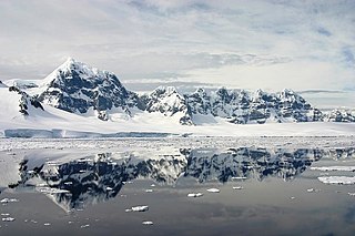
Danco Island or Isla Dedo is an island off Antarctica, 2 kilometres (1 nmi) long lying in the southern part of Errera Channel, off the west coast of Graham Land. It was charted by the Belgian Antarctic Expedition under Adrien de Gerlache, 1897–1899. Danco Island was surveyed by the Falkland Islands Dependencies Survey from Norsel in 1955, and named by the UK Antarctic Place-names Committee for Emile Danco (1869–1898), a Belgian geophysicist and member of the Belgian Antarctic Expedition, who died on board Belgica in the Antarctic.

Coronation Island is the largest of the South Orkney Islands, 25 nautical miles (46 km) long and from 3 to 8 nautical miles wide. The island extends in a general east-west direction, is mainly ice-covered and comprises numerous bays, glaciers and peaks, the highest rising to 1,265 metres (4,150 ft).

The Windmill Islands are an Antarctic group of rocky islands and rocks about 11.1 kilometres (6 nmi) wide, paralleling the coast of Wilkes Land for 31.5 kilometres (17 nmi) immediately north of Vanderford Glacier along the east side of Vincennes Bay. Kirkby Shoal is a small shoal area with depths of less than 18 metres (59 ft) extending about 140 metres (459 ft) westwards and SSW, about 3.4 kilometres (2.1 mi) from the summit of Shirley Island, Windmill Islands, and 0.24 kilometres (0.15 mi) NW of Stonehocker Point, Clark Peninsula.

Gain Glacier is a large glacier on the east coast of Palmer Land, Antarctica, flowing northeast from Cat Ridge and entering the Weddell Sea between Imshaug Peninsula and Morency Island. It was mapped by the United States Geological Survey in 1974, and was named by the Advisory Committee on Antarctic Names for Louis Gain, a naturalist on the French Antarctic Expedition, 1908–10, and the author of several of the expedition reports on zoology and botany.

Ineson Glacier is a glacier flowing northwest into Gin Cove, James Ross Island, Antarctica. Following geological work by the British Antarctic Survey (BAS), 1981–83, it was named by the UK Antarctic Place-Names Committee after Jonathan R. Ineson, a BAS geologist in the area.

Posadowsky Glacier is a glacier about 9 nautical miles long, flowing north to Posadowsky Bay immediately east of Gaussberg. Posadowsky Bay is an open embayment, located just east of the West Ice Shelf and fronting on the Davis Sea in Kaiser Wilhelm II Land. Kaiser Wilhelm II Land is the part of East Antarctica lying between Cape Penck, at 87°43'E, and Cape Filchner, at 91°54'E, and is claimed by Australia as part of the Australian Antarctic Territory. Other notable geographic features in this area include Drygalski Island, located 45 mi NNE of Cape Filchner in the Davis Sea, and Mirny Station, a Russian scientific research station.
The Melchior Islands are a group of many low, ice-covered islands lying near the center of Dallmann Bay in the Palmer Archipelago, Antarctica. They were first seen but left unnamed by a German expedition under Eduard Dallmann, 1873–74. The islands were resighted and roughly charted by the Third French Antarctic Expedition under Jean-Baptiste Charcot, 1903–05. Charcot named what he believed to be the large easternmost island in the group "Île Melchior" after Vice Admiral Jules Melchior of the French Navy, but later surveys proved Charcot's Île Melchior to be two islands, now called Eta Island and Omega Island. The name Melchior Islands has since become established for the whole island group now described, of which Eta Island and Omega Island form the eastern part, while the Sigma Islands mark the northern limit of the islands. The group was roughly surveyed in 1927 by Discovery Investigations personnel in the RRS Discovery, and was resurveyed by Argentine expeditions in 1942 and 1943, and again in 1948.

Lambda Island is an island lying immediately north-west of Delta Island in the Melchior Islands, of the Palmer Archipelago in Antarctica. The island, the largest in the north-western part of the island group, was first roughly charted and named "Île Sourrieu" by the French Antarctic Expedition, 1903–05 under Jean-Baptiste Charcot, but that name has not survived in usage. The current name, derived from lambda, the 11th letter of the Greek alphabet, was given by Discovery Investigations personnel who roughly charted the island in 1927. The island was surveyed by Argentine expeditions in 1942, 1943 and 1948.
Deadmond Glacier is a glacier about 6 nautical miles (11 km) long, flowing from the east side of Evans Peninsula on Thurston Island into Cadwalader Inlet. It was discovered by the U.S. Navy Bellingshausen Sea Expedition in February 1960, and was named by the Advisory Committee on Antarctic Names for Lieutenant Commander Robert B. Deadmond, executive officer of USS Burton Island, forming part of this expedition.

Dufayel Island is an island lying near the center of Ezcurra Inlet, Admiralty Bay, in the South Shetland Islands. It was charted and named in December 1909 by the French Antarctic Expedition under Jean-Baptiste Charcot.
Foley Glacier is a glacier about 4 nautical miles (7 km) long flowing north from the western end of Thurston Island just east of Cape Petersen. It was named by the Advisory Committee on Antarctic Names after Kevin M. Foley, of the United States Geological Survey, Reston, Virginia, a computer specialist and team member of the Glaciological and Coastal-Change Maps of Antarctica Project.
Goff Glacier is a broad glacier flowing from Parker Peak into the head of Koether Inlet on the north side of Thurston Island, Antarctica. It was named by the Advisory Committee on Antarctic Names after Lieutenant Robert G. Goff, co-pilot of PBM Mariner aircraft in the Eastern Group of U.S. Navy Operation Highjump, which obtained aerial photographs of Thurston Island and adjacent coastal areas, 1946–47.

Gourdin Island is the largest island (124 ha) in a group of islands and rocks 2 km (1 nmi) north of Prime Head, the northern tip of the Antarctic Peninsula. It was discovered by a French expedition, 1837–40, under Captain Jules Dumont d'Urville, and named by him for Ensign Jean Gourdin of the expedition ship Astrolabe. The island was reidentified and charted by the Falkland Islands Dependencies Survey in 1945–47.
Long Glacier is a glacier about 8 nautical miles long in the southeastern part of Thurston Island, Antarctica. It flows south to the Abbot Ice Shelf, 14 nautical miles (26 km) west of Harrison Nunatak. The glacier was mapped by the United States Geological Survey from surveys and U.S. Navy air photos, 1960–66, and was named by the Advisory Committee on Antarctic Names (US-ACAN) for Fred A. Long, Jr., an aviation machinist of U.S. Navy Squadron VX-6, who wintered at Little America V in 1957 and was in Antarctica in the 1960–61 and 1962–63 seasons.
Mincer Glacier is a broad glacier flowing from Zuhn Bluff into the southeast arm of Murphy Inlet on the north side of Thurston Island, Antarctica. It was named by the Advisory Committee on Antarctic Names after Lieutenant Dale F. Mincer, a co-pilot of PBM Mariner aircraft in the Eastern Group of U.S. Navy Operation Highjump, which obtained aerial photographs of Thurston Island and adjacent coastal areas in 1946–47.

Liotard Glacier is a channel glacier in Antarctica. It is about 3 nautical miles (6 km) wide and 6 nautical miles (11 km) long, and flows north-northeast from the continental ice, terminating in a small ice tongue about 4 nautical miles (7 km) west of Hélène Island. The glacier was delineated from air photos taken by U.S. Navy Operation Highjump, 1946–47, and was named by the Advisory Committee on Antarctic Names for Andre-Frank Liotard, the leader of the French Antarctic Expedition, 1949–51, whose group completed the initial survey of the coastal features as far westward as this glacier.
Mahaffey Glacier is a glacier flowing into the head of Morgan Inlet at the east end of Thurston Island, Antarctica. It was named by the Advisory Committee on Antarctic Names after J.S. Mahaffey, a Photographer's Mate in the Eastern Group of U.S. Navy Operation Highjump, which obtained aerial photographs of Thurston Island and adjacent coastal areas in 1946–47.
Marck Glacier is a glacier flowing into the southwestern extremity of Cadwalader Inlet on the north side of Thurston Island, Antarctica. It was named by the Advisory Committee on Antarctic Names after Aviation Machinist's Mate George H. Marck, an aircrewman in the Eastern Group of U.S. Navy Operation Highjump, which obtained aerial photographs of Thurston Island and adjacent coastal areas in the summer of 1946–47.
Levko Glacier is a glacier flowing from Pallid Crest to the eastern end of Thurston Island, Antarctica. It enters Seraph Bay between Tierney Peninsula and Simpson Bluff. The glacier was named by the Advisory Committee on Antarctic Names after G. Levko, Photographer's Mate in the Eastern Group of U.S. Navy Operation Highjump, which obtained aerial photographs of Thurston Island and adjacent coastal areas, 1946–47.