Casemate Fort, Whiting Quadrangle

Last updated
Casemate Fort, Whiting Quadrangle
Fort Hamilton Community Club.jpg
Casemate Fort, November 2006
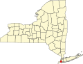
USA New York City location map.svg
Red pog.svg
USA New York location map.svg
Red pog.svg
Usa edcp location map.svg
Red pog.svg
LocationFort Hamilton, off NY 27, New York, New York
Coordinates 40°36′31″N74°1′58″W / 40.60861°N 74.03278°W / 40.60861; -74.03278 Coordinates: 40°36′31″N74°1′58″W / 40.60861°N 74.03278°W / 40.60861; -74.03278
Area2 acres (0.81 ha)
Built1825
NRHP reference No. 74001249 [1]
Added to NRHPAugust 7, 1974

Casemate Fort, Whiting Quadrangle, also known as "Old Casemate," Officers Club Bldg. #207, Sentry Booth #220, and Fort Hamilton Community Club, is a historic building located in Fort Hamilton, Brooklyn, New York, New York. The old fort was designed in 1819 and built between 1825 and 1836. It is a brick and stone "C" shaped structure with all walls approximately three feet thick. The building and adjoining stone walls form a type of fortification known as a "walled enceinte". [2]

It was listed on the National Register of Historic Places in 1974. [1]

Related Research Articles

Citadelle of Quebec Building in Quebec, Canada

The Citadelle of Quebec, also known as La Citadelle, is an active military installation and the secondary official residence of both the Canadian monarch and the governor general of Canada. It is located atop Cap Diamant, adjoining the Plains of Abraham in Quebec City, Quebec. The citadel contains the oldest military building in Canada, and forms part of the fortifications of Quebec City, which is one of only two cities in North America still surrounded by fortifications, the other being Campeche, Mexico.

New Utrecht, Brooklyn

New Utrecht was a town in western Long Island, New York encompassing all or part of the present-day Bath Beach, Bay Ridge, Bensonhurst, Borough Park, Dyker Heights and Fort Hamilton neighborhoods of Brooklyn, New York City. New Utrecht was established in 1652 by Dutch settlers in the Dutch colony of New Netherland, the last of the original six towns to be founded in Kings County. New Utrecht ceased to exist in 1894 when it was annexed by the City of Brooklyn, and became part of the City of Greater New York when Brooklyn joined as a borough in 1898.

Fort Mifflin

Fort Mifflin, originally called Fort Island Battery and also known as Mud Island Fort, was commissioned in 1771 and sits on Mud Island on the Delaware River below Philadelphia, Pennsylvania near Philadelphia International Airport. During the American Revolutionary War, the British Army bombarded and captured the fort as part of their conquest of Philadelphia in autumn 1777. In 1795 the fort was renamed for Thomas Mifflin, a Continental Army officer and the first post-independence Governor of Pennsylvania. The United States Army began to rebuild the fort in 1794 and continued to garrison and build on the site through the 19th century. It housed prisoners during the American Civil War. The army decommissioned Fort Mifflin for active duty infantry and artillery in 1962. However, while the older portion of the fort was returned to the City of Philadelphia, a portion of the fort's grounds are still actively used by the United States Army Corps of Engineers, making it the oldest fort in military use in the United States. Historic preservationists have restored the fort, which is now a National Historic Landmark.

Fort Hamilton U.S. Army installation in Brooklyn, NY

Fort Hamilton is a United States Army installation in the southwestern corner of the New York City borough of Brooklyn, surrounded by the communities of Bay Ridge and Dyker Heights. It is one of several posts that are part of the region which is headquartered by the Military District of Washington. Its mission is to provide the New York metropolitan area with military installation support for the Army National Guard and the United States Army Reserve. The original fort was completed in 1831, with major additions made in the 1870s and 1900s. However, all defenses except about half of the original fort have been demolished or buried.

Fort Monroe Moated, six-sided, historical bastion fort in Hampton, Virginia

Fort Monroe, preserved as the Fort Monroe National Monument, is a decommissioned military installation in Hampton, Virginia, at Old Point Comfort, the southern tip of the Virginia Peninsula, United States. Along with Fort Wool, Fort Monroe originally guarded the navigation channel between the Chesapeake Bay and Hampton Roads—the natural roadstead at the confluence of the Elizabeth, the Nansemond and the James rivers. Until disarmament in 1946, the areas protected by the fort were the entire Chesapeake Bay and Potomac River regions, including the water approaches to the cities of Washington, D.C. and Baltimore, Maryland, along with important shipyards and naval bases in the Hampton Roads area. Surrounded by a moat, the six-sided bastion fort is the largest fort by area ever built in the United States.

Fort Zachary Taylor Historic State Park United States historic place

The Fort Zachary Taylor Historic State Park, better known simply as Fort Taylor is a Florida State Park and National Historic Landmark centered on a Civil War-era fort located near the southern tip of Key West, Florida.

Fort Totten (Queens)

Fort Totten is a former active United States Army installation in the New York City borough of Queens. It is located on the Willets Point peninsula on the north shore of Long Island. Fort Totten is at the head of Little Neck Bay, where the East River widens to become Long Island Sound. While the U.S. Army Reserve continues to maintain a presence at the fort, the property is now owned by the City of New York.

Fort Frederick State Park

Fort Frederick State Park is a public recreation and historic preservation area on the Potomac River surrounding the restored Fort Frederick, a fortification active in the French and Indian War (1754–1763) and the American Revolutionary War (1775-1783). The state park lies south of the town of Big Pool, Maryland. The Chesapeake and Ohio Canal runs through the park grounds. The site was designated a National Historic Landmark in 1973.

Fort Hancock, New Jersey Former United States Army fort

Fort Hancock is a former United States Army fort at Sandy Hook in Middletown Township New Jersey. The coastal artillery base defended the Atlantic coast and the entrance to New York Harbor, with its first gun batteries operational in 1896. The fort served from then until 1950 as part of the Harbor Defenses of New York and predecessor organizations. Between 1874 and 1919, the adjacent US Army Sandy Hook Proving Ground was operated in conjunction with Fort Hancock. It is now part of Fort Hancock Memorial Park. It was preceded by the Fort at Sandy Hook, built 1857–1867 and demolished beginning in 1885.

Fort Tilden

Fort Tilden, also known as Fort Tilden Historic District, is a former United States Army installation on the coast in the New York City borough of Queens. Fort Tilden now forms part of the Gateway National Recreation Area, and is administered by the National Park Service.

Fort Klock United States historic place

Fort Klock, a fortified stone homestead in the Mohawk River Valley of Upstate New York, was built c.1750 by Johannes Klock, and is a good example of a mid-18th century fortified home and trading post, seeing use during the French and Indian War and the American Revolutionary War The fort is located at 7203 Route 5 roughly two miles (3 km) east of the Village of St. Johnsville, New York. Fort Klock is part of a 30-acre (12 ha) complex that includes the historic homestead, a renovated Colonial Dutch Barn, blacksmith shop, and 19th-century schoolhouse. The site is maintained by Fort Klock Historic Restoration and is open seasonally as a living museum. The fort was declared a National Historic Landmark in 1972.

Castle Williams

Castle Williams is a circular fortification of red sandstone on the northwest point of Governors Island, part of a system of forts designed and constructed in the early 19th century to protect New York City from naval attack. It is a prominent landmark in New York Harbor. Together with Fort Jay, it is managed by the National Park Service as part of Governors Island National Monument.

Old Faithful Historic District United States historic place

The Old Faithful Historic District in Yellowstone National Park comprises the built-up portion of the Upper Geyser Basin surrounding the Old Faithful Inn and Old Faithful Geyser. It includes the Old Faithful Inn, designed by Robert Reamer and is itself a National Historic Landmark, the upper and lower Hamilton's Stores, the Old Faithful Lodge, designed by Gilbert Stanley Underwood, the Old Faithful Snow Lodge, and a variety of supporting buildings. The Old Faithful Historic District itself lies on the 140-mile Grand Loop Road Historic District.

Old Stone Barracks United States historic place

The "Old Stone Barracks" is the last remaining structure of a proposed quadrangle of early U.S. Army barracks built at Plattsburgh, New York in 1838. Of the four main buildings initially planned for the Plattsburgh post, only two were ever constructed, an officer's barracks and an enlisted barracks which formed an "L" shape. The buildings were utilized by the Army for nearly a Century. The officer's quarters, in which Lt. Ulysses S. Grant once stayed, was torn down by the U.S. Air Force during the winter of 1963. The remaining building, the 200-foot (61 m) long, two story "Old Stone Barracks," remained mostly empty after the early 1960s and was added to the National Register of Historic Places in 1971. In December 2010 the Barracks and more than 7 acres of property was offered to a Canadian real estate developer for $35,000 with the intention of building an apartment complex on the historic site. At the time, the Barracks property was appraised at over $775,000 and the sale sparked public outcry for its preservation. In 2014, the building was again sold to current owners Terry Schmaltz and Mary Theresa Pearl who redeveloped it as the home of the "Valcour Brewing Company." The new craft brewery is set to open early in 2016.

Madison Barracks United States historic place

Madison Barracks was a military installation established in 1813 or 1815 at Sackets Harbor that was built for occupation by 600 U.S. troops, a few years after the War of 1812. It was named for James Madison who had just completed his presidency in 1817. Construction began under the name Fort Pike. The facility is a National Historic Landmark and a historic district located in Jefferson County, New York. The district includes 86 contributing buildings and two contributing structures. It includes the stone hospital, bakery, several warehouses known as "Stone Row," a stone water tower, and a series of brick buildings constructed in the 1890s as officers quarters, barracks, mess hall, and weapons storage and repair building.

Hascall Hall United States historic place

Hascall Hall is a historic institutional building located on the campus of Colgate University at Hamilton in Madison County, New York. It was built in 1884 and is a two-story stone building with brick trim measuring 40 feet by 70 feet. An addition was completed in 1906. The original section features a hipped roof of slate, eyebrow windows, and a large semicircular archway entrance.

Bellona Arsenal United States historic place

Bellona Arsenal was a 19th-century United States Army post in Chesterfield County, Virginia, above the fall line of the James River east of Richmond, Virginia. Ruins of a powder magazine and other buildings are still standing. The site is listed on the National Register of Historic Places.

Christman Bird and Wildlife Sanctuary United States historic place

Christman Bird and Wildlife Sanctuary is a national historic district located near Delanson, Schenectady County, New York. The district includes six contributing buildings and one contributing structure on a largely wooded, rural 105-acre (42 ha) tract. It lies in the valley of the Bozenkill and includes a 30-foot (9.1 m) waterfall along the Helderberg Escarpment. Located on the property is a two-story frame dwelling built in 1868, a stone dairy house, barns, large stone walls, and an open lean-to built by the Mohawk Valley Hiking Club. The sanctuary had its beginnings in 1888 when property owner W.W. Christman (1865-1937) and his wife, the former Catherine Bradt, began a winter bird feeding program during the great blizzard of that year.

Fort Totten Officers Club United States historic place

Fort Totten Officers' Club, also known as the Castle, is a historic clubhouse located at Fort Totten in Bayside, Queens, New York. It was built in the 1870s and expanded to its present size in 1887. It is a large Late Gothic Revival style building. It is a two-story, rectangular frame building with a projecting central tower pavilion and sheathed in clapboard. It features identical, polygonal, three story towers and a wood parapet surrounding the roofline.

References

  1. 1 2 "National Register Information System". National Register of Historic Places . National Park Service. March 13, 2009.
  2. A.D. Griswold (June 1973). "National Register of Historic Places Registration:Casemate Fort, Whiting Quadrangle". New York State Office of Parks, Recreation and Historic Preservation. Archived from the original on 2012-10-19. Retrieved 2011-02-20.