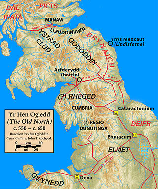
Rheged was one of the kingdoms of the Hen Ogledd, the Brittonic-speaking region of what is now Northern England and southern Scotland, during the post-Roman era and Early Middle Ages. It is recorded in several poetic and bardic sources, although its borders are not described in any of them. Archaeological work from 2012 onwards suggests that its stronghold was located in what is now Galloway in Scotland rather than, as was previously speculated, being in Cumbria. Rheged possibly extended into Lancashire and other parts of northern England. In some sources, Rheged is intimately associated with the king Urien Rheged and his family. Its inhabitants spoke Cumbric, a Brittonic dialect closely related to Old Welsh.

Carlisle is a city located in the Northern English county of Cumbria. It is administrated by Cumberland Council, which covers an area similar to the historic county of Cumberland.

Westmorland is an area of North West England which was historically a county. People of the area are known as Westmerians. The area includes part of the Lake District and the southern Vale of Eden.

Cumberland is an area of North West England which was historically a county. The county was bordered by Northumberland to the north-east, County Durham to the east, Westmorland to the south-east, Lancashire to the south, and the Scottish counties of Dumfriesshire and Roxburghshire to the north. The area includes the city of Carlisle, part of the Lake District and North Pennines, and the Solway Firth coastline.

Penrith is a market town and civil parish in the Westmorland and Furness district of Cumbria, England. It is less than 3 miles (5 km) outside the Lake District National Park and about 17 miles (27 km) south of Carlisle. It is between the Rivers Petteril and Eamont and just north of the River Lowther. The town had a population of 15,181 at the 2011 census. It is part of historic Cumberland.
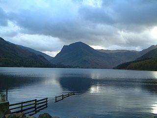
Buttermere is a lake in the Lake District in North West England. It has a length of approximately 2 kilometres (1.2 mi) and a maximum width of 0.54 kilometres (0.34 mi), an area of 0.9 square kilometres (0.35 sq mi), a maximum depth of 28.6 metres (94 ft), and a surface elevation of 100.3 metres (329 ft) above sea level. Its primary outflow is Buttermere Dubs, a short stream which connects the lake to Crummock Water. From Crummock Water the River Cocker flows to Cockermouth, where it joins the River Derwent and finally enters the Irish Sea at Workington. The lake is in the unitary authority of Cumberland, and the ceremonial county of Cumbria.

The Eden Valley Railway (EVR) was a railway in Cumbria, England. It ran between Clifton Junction near Penrith and Kirkby Stephen via Appleby-in-Westmorland.
Urien ap Cynfarch Oer or Urien Rheged was a powerful sixth-century Brittonic-speaking figure who was possibly the ruler of the territory or kingdom known as Rheged. He is probably the best-known and certainly the best documented of the British figures of the 'Old North' in the sixth century. His kingdom was most likely centred around the Solway Firth. The most secure evidence for his existence comes from a ninth-century Welsh history and eight praise-poems in Middle Welsh dedicated to him surviving in a fourteenth-century manuscript. Despite their being found in Middle Welsh orthography, the poems may possibly reflect earlier material, even material contemporaneous to Urien. One of these poems is explicitly attributed to the famed poet Taliesin in the manuscript. The early material paints Urien as a ferocious warrior and a major political figure in his time, conquering Picts, Anglo-Saxons, and Britons of the 'Old North' alike. According to the Historia Brittonum, Urien, with three other kings confederate with him, nearly exterminated the newly-arrived Anglo-Saxons in Britain, though this campaign was brought to an abrupt end when Urien was murdered by one of his allies. In addition to this earlier material, Urien and his family feature elsewhere in medieval literature from Wales. Outside of the historical Welsh context, he eventually was transformed in Arthurian legend into the figure of king Urien of Garlot or Gorre. His most celebrated son, Owain, likewise gave his name to the Arthurian character of Ywain.
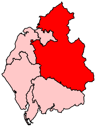
Penrith and The Border was a constituency in Cumbria represented in the House of Commons of the UK Parliament. Throughout its existence it elected only members of the Conservative Party.
Penrith was a rural district within the administrative county of Cumberland, England that existed from 1894 to 1974 with slight boundary changes in 1934.

Hesket is a large civil parish in the Westmorland and Furness unitary district of Cumbria, England, on the main A6 between Carlisle and Penrith. At the 2001 census it had a population of 2,363, increasing to 2,588 at the 2011 census, and estimated at 2,774 in 2019. The parish was formed in 1894 with the passing of the Local Government Act 1894 and was enlarged to incorporate the parish of Plumpton Wall following a County Review Order in 1934. Hesket is part of the historic royal hunting ground of Inglewood Forest. Settlement in the parish dates back to the Roman occupation.

Inglewood Forest is a large tract of mainly arable and dairy farm land with a few small woodland areas between Carlisle and Penrith in the English non-metropolitan county of Cumbria or ancient county of Cumberland.

The history of Cumbria as a county of England begins with the Local Government Act 1972. Its territory and constituent parts however have a long history under various other administrative and historic units of governance. Cumbria is an upland, coastal and rural area, with a history of invasions, migration and settlement, as well as battles and skirmishes between the English and the Scots.

The A686 is a road in Northern England. It runs from Penrith in Cumbria to Haydon Bridge in Northumberland. AA Magazine named the A686 as one of their "Ten Great Drives" owing to the dramatic scenery of the North Pennines hills encountered along its route. Travel journalist Phil Llewellin said:
England’s great wilderness sprawls across the northern Pennines, where the mountains have fascinating names such as Fiend’s Fell and Wildboar Fell. Penrith merits a visit after leaving the M6, and memories of the motorway fade as the A686 crosses the River Eden valley. The mood changes dramatically in Melmerby, where the road starts its long climb to the cafe at Hartside, 1,900 feet (580 m) above sea level, with stunning views across the Solway Firth and Scotland. The road leads to Alston, which claims to be England’s highest market town, a charming little place with cobbled streets and quaint buildings. The A686 beyond Alston crosses another breathtaking expanse of windswept upland before running down to the River Allen's beautiful wooded gorge.
Luguvalium was an ancient Roman city in northern Britain located within present-day Carlisle, Cumbria, and may have been the capital of the 4th-century province of Valentia. It was the northernmost city of the Roman Empire.

Kendal Castle is a medieval fortification to the east of the town of Kendal, Cumbria, in northern England. The castle, which is atop a glacial drumlin, was built in the 13th century as the Caput baroniae for the Barony of Kendal. By the 15th century, the Parr family owned the castle.

Hutton in the Forest is a Grade I listed country house near the village of Skelton in the historic county of Cumberland, which now forms part of the modern county of Cumbria, England. It belonged to the Fletcher-Vane family from 1605 until 1931 when it became the property of the Barons Inglewood who were distant relatives of the Fletcher-Vane family.
The history of medieval Cumbria has several points of interest. The region's status as a borderland coping with 400 years of warfare is one. The attitude of the English central government, at once uninterested and deeply interested, is another. As a border region, of geopolitical importance, Cumbria changed hands between the Angles, Norse, Strathclyde Brythons, Picts, Normans, Scots and English; and the emergence of the modern county is also worthy of study.
Tarn Wadling was a lake between Carlisle and Penrith, near the village of High Hesket in Cumbria, England. In the Middle Ages, it was famous for its carp, but it was drained in the 19th century, and is now no more than a depression. The name remains today in a small woodland governed by the Woodland Trust.
