
Emery County is a county in east-central Utah, United States. As of the 2020 United States Census, the population was 9,825. Its county seat is Castle Dale, and the largest city is Huntington.

Summit County is a county in the U.S. state of Utah, occupying a rugged and mountainous area. As of the 2020 United States Census, the population was 42,357. Its county seat is Coalville, and the largest city is Park City.

Prescott Valley is a town located in Yavapai County, Arizona, United States, approximately 8 miles (13 km) east of Prescott. According to the 2020 United States Census, Prescott Valley has a population of 46,785 residents.
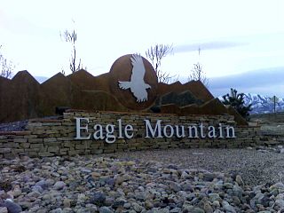
Eagle Mountain is a city in Utah County, Utah. It is part of the Provo–Orem metropolitan area. The city is located to the west as well as north of the Lake Mountains, which are west of Utah Lake. It was incorporated in December 1996 and is rapidly growing. The population was 43,623 at the 2020 census. Eagle Mountain was a town in 2000. It has since been classified as a third-class city in September 2001. In its short history, the city has become known for its rapid growth.

Park City is a city in Utah, United States. The vast majority is in Summit County with some portions extending into Wasatch County. It is considered to be part of the Wasatch Back. The city is 32 miles (51 km) southeast of downtown Salt Lake City and 20 miles (32 km) from Salt Lake City's east edge of Sugar House along Interstate 80. The population was 8,396 at the 2020 census. On average, the tourist population greatly exceeds the number of permanent residents.

Camp Floyd State Park Museum is a state park in the Cedar Valley in Fairfield, Utah, United States. The park includes a small part of the former Camp Floyd site, the Stagecoach Inn, and the Fairfield District School.
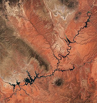
Lake Powell is a reservoir on the Colorado River in Utah and Arizona, United States. It is a major vacation destination visited by approximately two million people every year. It holds 24,322,000 acre-feet (3.0001×10¹⁰ m3) of water when full, second in the United States to only Lake Mead - though Lake Mead has fallen below Lake Powell in size several times during the 21st century in terms of volume of water, depth and surface area.

The Sevier River is a 400-mile (640 km)-long river in the Great Basin of southwestern Utah in the United States. Originating west of Bryce Canyon National Park, the river flows north through a chain of high farming valleys and steep canyons along the west side of the Sevier Plateau before turning southwest and terminating in the endorheic basin of Sevier Lake in the Sevier Desert. It is used extensively for irrigation along its course, with the consequence that Sevier Lake is usually dry.

Echo is a census-designated place located in northwestern Summit County, Utah, United States. The population was 56 at the 2010 census.
The Desatoya Mountains are located in central Nevada in the western United States, approximately 117 miles east of Reno by road. The range runs in a southwest-northeasterly direction along the border of Churchill and Lander counties, reaching a maximum elevation of 9,978 feet (3,041 m) at Desatoya Peak near Rock Creek Canyon.

U.S. Route 50 (US 50) is a transcontinental highway in the United States, stretching from West Sacramento, California, in the west to Ocean City, Maryland, on the east coast. The Nevada portion crosses the center of the state and was named "The Loneliest Road in America" by Life magazine in July 1986. The name was intended as a pejorative, but Nevada officials seized it as a marketing slogan. The name originates from large desolate areas traversed by the route, with few or no signs of civilization. The highway crosses several large desert valleys separated by numerous mountain ranges towering over the valley floors, in what is known as the Basin and Range province of the Great Basin.

Arvagh, or Arva, is a village in County Cavan, Ireland, on the shores of Garty Lough and overlooked by Bruse Mountain. It is located on the junction of the R198 and R203 regional roads.

Castle Gate is a ghost town in the western United States, located in Carbon County in eastern Utah. A mining town approximately ninety miles (140 km) southeast of Salt Lake City, its name was derived from a rock formation near the mouth of Price Canyon. This formation features two sheer sandstone walls on either side of the Price River, which appear to open like a giant gate as travelers approach this narrow section of the canyon.
Faust is a settlement located in central Tooele County, Utah, United States.

Interstate 80 (I-80) is a part of the Interstate Highway System that runs from San Francisco, California, to Teaneck, New Jersey. The portion of the highway in the US state of Utah is 197.51 miles (317.86 km) long through the northern part of the state. From west to east, I-80 crosses the state line from Nevada in Tooele County and traverses the Bonneville Salt Flats—which are a part of the larger Great Salt Lake Desert. It continues alongside the Wendover Cut-off—the corridor of the former Victory Highway—US Route 40 (US-40) and the Western Pacific Railroad Feather River Route. After passing the Oquirrh Mountains, I-80 enters the Salt Lake Valley and Salt Lake County. A short portion of the freeway is concurrent with I-15 through Downtown Salt Lake City. At the Spaghetti Bowl, I-80 turns east again into the mouth of Parleys Canyon and Summit County, travels through the mountain range, and intersects the eastern end of I-84 near Echo Reservoir before turning northeast toward the Wyoming border near Evanston. I-80 was built along the corridor of the Lincoln Highway and the Mormon Trail through the Wasatch Range. The easternmost section also follows the historical routes of the first transcontinental railroad and US-30S.
Grass Creek is a ghost town in Summit County, Utah, United States. Lying some 8 miles (13 km) northeast of Coalville, it was once an important coal mining town. Grass Creek was inhabited circa 1860–1940.

Barlow is a populated place between the Gettysburg Battlefield and the Mason–Dixon line in Adams County, Pennsylvania, United States, situated at the intersection of Rock Creek and Pennsylvania Route 134. North of the creek on the road summit is the principal facility of the rural community: the 1939 community hall at the Barlow Volunteer Fire Company fire station. The hall is a Cumberland Township polling place and was used by Mamie and Dwight D. Eisenhower after purchasing their nearby farm. Horner's Mill was the site of an 1861 Union Civil War encampment, and the covered bridge was used by the II Corps and General George G. Meade en route to the 1863 Battle of Gettysburg.

The Mud Springs Station Archaeological District, which includes the Mud Springs Pony Express Station Site, near Dalton, Nebraska, has significance dating to the mid-19th century. The Pony Express station at Mud Springs, staffed by U.S. soldiers, was attacked by Lakota, Cheyenne, and Arapaho tribesmen during February 4–6, 1865, in what became known as the Battle of Mud Springs.
Jacobsville is a ghost town located in Lander County, Nevada, six miles west of Austin, on the east bank of Reese River, 0.7 mi N of US 50. Jacobsville was also known as Jacobs Spring, Jacobsville Station, Reese River and Reese River Station.

