Castra of Aradul Nou

Last updated
Castra of Aradul Nou
Romania location map.svg
Red pog.svg
Location within Romania
Founded2nd century AD [1]
Abandoned2nd century AD [1]
Place in the Roman world
Province Dacia
Administrative unit Dacia Apulensis
Administrative unit Dacia Superior
Nearby water Marisus
Directly connected to Morisena(Lipova)
Stationed military units
Legions
vexill. XIII Gemina, [2] vexill. IV Flavia Felix
Location
Coordinates 46°08′29″N21°17′59″E / 46.14149°N 21.29969°E / 46.14149; 21.29969
Place nameAradul Nou neighborhood [3]
Town Arad
County Arad
CountryFlag of Romania.svg  Romania
Reference
RO-LMI AR-I-s-B-00423
RO-RAN 9271.01
Site notes
Recognition Monument istoric.svg National Historical Monument
ConditionUnidentified [3]
Exhibitions Muzeul de Arheologie și Istorie Arad

The castra of Aradul Nou was a fort in the Roman province of Dacia, [1] located on the western side of the defensive line of forts, limes Daciae. It is situated near Arad, Romania. [2] [3]

Contents

Western Dacia forts Western Dacia forts.png
Western Dacia forts

Development and function

The large Dacian settlement, located on the southern edge of the present-day city of Arad, was burned down by the Roman army during the first Dacian war, between 101 - 102 AD. During the Second Dacian War (105-106 AD) Trajan also occupied the lands north of Marisus and incorporated them into the province of Dacia Superior.

The fort was probably built in the early 2nd century by legionary vexillationes. An auxiliary cohort possibly stationed later in this fort was responsible among other things for monitoring and securing the road connection from Micia to Partiscum, [2] [3] which followed the southern bank of the river Mureș towards the northwest.

Four brick stamps of Legio XIII Gemina and Legio IIII Flavia Felix confirm the identification of the site as a Roman military complex. [2] [3] Their bricks were often found on the lower reaches of Mureș, for example in Bulci, Cladova, Periam, Sânnicolau Mare and Szeged, which probably shows that the Romans had already brought this area under control at the beginning of their rule in Dacia. The brick stamps are now in the Museum of Archaeology and History (Romanian Muzeul de Arheologie și Istorie), in Arad.

Monument protection

The entire archaeological site, and in particular the fort, are protected as historical monuments.

Brick stamp of the Legio IV Flavia Felix from the Castra of Aradul Nou ZST Aradul Nou Lec IIII FF.jpg
Brick stamp of the Legio IV Flavia Felix from the Castra of Aradul Nou

See also

Notes

  1. 1 2 3 Bejan, Adrian (1998). Dacia Felix: Istoria Daciei romane ("Dacia Felix: A History of Roman Dacia") (PDF) (in Romanian). Timişoara. p. 44. Archived from the original (PDF) on 2012-03-15.{{cite book}}: CS1 maint: location missing publisher (link)
  2. 1 2 3 4 "Aradul Nou". STRATEG MAPS: Defensive strategies and trans-border policies at the Lower Danube in Roman Antiquity (An interdisciplinary project). Archived from the original on 2012-05-14. Retrieved 5 January 2013.
  3. 1 2 3 4 5 Gudea, Nicolae (1997). "Der Dakische Limes: Materialien zu seiner Geschichte ("The Dacian Limes: Material for its History")" (PDF). Jahrbuch des Römisch-Germanischen Zentralmuseums Mainz (in German). 2 (44). Mainz, Germany: Römisch-Germanischen Zentralmuseums Mainz: 23. Archived from the original (PDF) on 2018-10-05. Retrieved 4 January 2013.

Related Research Articles

<i>Limes Porolissensis</i>

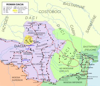
Located in Roman province of Dacia, present-day Romania, the Limes Porolissensis was a frontier of the Roman empire in Dacia Porolissensis, the northernmost of the three Dacian provinces. It was a defensive line dating from the 2nd century AD after the Conquest of Dacia. The frontier was a complex network of over 100 observation towers, fortlets, walls and forts disposed in a line over 200 km from the Apuseni Mountains to the Eastern Carpathians, following the highland chain of the Meseș Mountains.

<i>Moesian Limes</i> Collection of Roman fortifications

The Moesian Limes is the modern term given to a linked series of Roman forts on the northern frontier of the Roman province of Moesia along the Danube between the Black Sea shore and Pannonia and dating from the 1st century AD. It was the eastern section of the so-called Danubian Limes and protected the Roman provinces of Upper and Lower Moesia south of the river. The eastern section is often called the limes Scythiae minoris as it was located in the late Roman province of Scythia Minor.

<span class="mw-page-title-main">Arad, Romania</span> Municipality in Arad County, Romania

Arad is the capital city of Arad County, at the edge of Crișana and the Banat. No villages are administred by the city. It is the third largest city in Western Romania, behind Timișoara and Oradea, and the 12th largest in Romania, with a population of 145,078.

<span class="mw-page-title-main">Limes Transalutanus</span> Fortified frontier system of the Roman Empire

Limes Transalutanus is the modern name given to a fortified frontier system of the Roman Empire, built on the western edge of Teleorman's forests as part of the Dacian Limes in the Roman province of Dacia, modern-day Romania.

<span class="mw-page-title-main">Limes Alutanus</span> Roman limes of Dacia (modern Romania)

The Limes Alutanus was a fortified eastern border of the ancient Roman province of Dacia built by the Roman emperor Hadrian to stop invasions and raids from the east.

<span class="mw-page-title-main">Acidava</span>

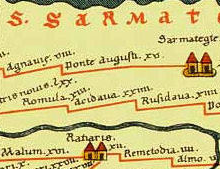
Acidava (Acidaua) was a Dacian and later Roman town and fort on the Olt river near the lower Danube. The settlement's remains are located in today's Enoşeşti, Olt County, Oltenia, Romania.

<span class="mw-page-title-main">Ziridava</span> Dacian fortified settlement

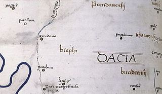
Ziridava was a Dacian town located between Apulon and Tibiscum, mentioned by Ptolemy in the area of the Dacian tribe of Biephi.

<span class="mw-page-title-main">Castra of Bulci</span> Fort in the Roman province of Dacia

The castra of Bulci was a fort in the Roman province of Dacia located on the western side of defensive line of forts, limes Daciae. Its ruins are located in Bulci.

<span class="mw-page-title-main">Angustia (castra)</span>

Angustia was a fort in the Roman province of Dacia in the 2nd and 3rd centuries AD today near the town of Breţcu, Romania.

Castra Acidava was a fort in the Roman province of Dacia, The toponym is attested in the Peutinger Table. built near the ancient town of Acidava.

<span class="mw-page-title-main">Buridava (castra)</span> Fort in the Roman province of Dacia, present-day Romania

Castra Buridava was a fort in the Roman province of Dacia, part of the frontier system of the Limes Alutanus, and near the Dacian and Roman town of Buridava.

Morisena was a castra in the Roman province of Dacia. Morisena was a Roman auxiliary camp and part of the outline in the western fortress chain of the Dacian Limes. It was located within the modern municipality of Cenad, Romania.

<span class="mw-page-title-main">Castra of Hoghiz</span> Fort in the Roman province of Dacia

The castra of Hoghiz was a fort in the Roman province of Dacia. The fort was built in the 2nd century AD, on the left bank of the Olt River, at a place where a Dacian settlement existing already in the 2nd century BC was unearthed. The fort and the nearby village were abandoned in the 3rd century AD. The ruins of the castra are located in Hoghiz, Romania.

<span class="mw-page-title-main">Germisara (castra)</span>

Germisara was a fort in the Roman province of Dacia, in modern day Romania, in the village area of Cigmău, in Romania.

The castra of Drumul Carului was a fort in the Roman province of Dacia near Moieciu, Romania.

<span class="mw-page-title-main">Pietroasele fort</span>

The castra of Pietroasele was a Roman fort in Roman Dacia located in the centre of Pietroasele (Romania). It was built under Trajan after Trajan's Dacian Wars in about 106 AD but abandoned at the beginning of Hadrian's reign when Wallachia was given up to the Roxolani. It was used again at the beginning of the 3rd century in the reign of Caracalla. It was rebuilt by Constantine the Great after his victory over the Goths in 328 when Constantine created the Constantine Wall of the Dacian Limes. It was abandoned in the same century.

<span class="mw-page-title-main">Castra of Tihău</span> Roman fort in Dacia

It was a fort in the Roman province of Dacia.

<span class="mw-page-title-main">Dacian Limes</span> Collection of Roman fortifications

The Dacian Limes is the generic modern term given to a collection of ramparts and linked series of Roman forts on the frontiers of the Roman province of Dacia dating from the early 2nd century AD. They ran for about 1,000 km and included the:

The Main Limes, also called the Nasser Limes, was built around 90 AD and, as part of the Upper Germanic-Rhaetian Limes, formed the frontier of the Roman Empire in the area between the present day villages of Großkrotzenburg and Bürgstadt. In this section the limes adjoined the River Main (Moenus), which forms a natural boundary for about 50 kilometres here, so "Main" refers to the river.

References

46°11′N21°19′E / 46.183°N 21.317°E / 46.183; 21.317