
Covent Garden is a district in London, on the eastern fringes of the West End, between St Martin's Lane and Drury Lane. It is associated with the former fruit-and-vegetable market in the central square, now a popular shopping and tourist site, and with the Royal Opera House, itself known as "Covent Garden". The district is divided by the main thoroughfare of Long Acre, north of which is given over to independent shops centred on Neal's Yard and Seven Dials, while the south contains the central square with its street performers and most of the historical buildings, theatres and entertainment facilities, including the London Transport Museum and the Theatre Royal, Drury Lane.
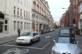
Drury Lane is a street on the eastern boundary of the Covent Garden area of London, running between Aldwych and High Holborn. The northern part is in the borough of Camden and the southern part in the City of Westminster. Drury Lane is part of London's West End Theatreland.

The Strand is a major street in the City of Westminster, Central London. The street, which is part of London's West End theatreland, runs just over 3⁄4 mile (1.2 km) from Trafalgar Square eastwards to Temple Bar, where it becomes Fleet Street in the City of London, and is part of the A4, a main road running west from inner London.

Aldwych is a street and the name of the area immediately surrounding it, in the City of Westminster, part of Greater London, and is part of the West End Theatreland. The 450 metres (1,480 ft) street starts 600 metres (2,000 ft) east-northeast of Charing Cross, the conventional map centre-point of the capital city.

Tavistock is an ancient stannary and market town in West Devon, England. It is situated on the River Tavy, from which its name derives. At the 2011 census, the three electoral wards had a population of 13,028. The town traces its recorded history back to at least 961 when Tavistock Abbey, whose ruins lie in the centre of the town, was founded. Its most famous son is Sir Francis Drake.

Russell Square is a large garden square in Bloomsbury, in the London Borough of Camden, built predominantly by the firm of James Burton. It is near the University of London's main buildings and the British Museum. Almost exactly square, to the north is Woburn Place and to the south-east is Southampton Row. Russell Square tube station sits to the north-east.

Jermyn Street is a one-way street in the St James's area of the City of Westminster in London, England. It is to the south of, parallel, and adjacent to Piccadilly. Jermyn Street is known as a street for gentlemen's-clothing retailers in the West End.
The WC postcode area, also known as the London WC postcode area, is a group of postcode districts in central London, England. The area covered is of high density development, and includes parts of the City of Westminster and the London Boroughs of Camden and Islington, plus a very small part of the City of London.

The Theatre Royal, Drury Lane, commonly known as Drury Lane, is a West End theatre and Grade I listed building in Covent Garden, London, England. The building faces Catherine Street and backs onto Drury Lane. The present building, opened in 1812, is the most recent of four theatres that stood at the location since 1663, making it the oldest theatre site in London still in use. According to the author Peter Thomson, for its first two centuries, Drury Lane could "reasonably have claimed to be London's leading theatre". For most of that time, it was one of a handful of patent theatres, granted monopoly rights to the production of "legitimate" drama in London.

The Phoenix Theatre is a West End theatre in the London Borough of Camden, located in Charing Cross Road. The entrances are on Phoenix Street and Charing Cross Road. The Phoenix Theatre was built on the site of a former factory and then music hall Alcazar before.

Tavistock Abbey, also known as the Abbey of Saint Mary and Saint Rumon, is a ruined Benedictine abbey in Tavistock, Devon. The Abbey was surrendered in 1539 during the Dissolution of the Monasteries. Nothing remains of the abbey except the refectory, two gateways and a porch. The abbey church, dedicated to Our Lady and St Rumon, was destroyed by Danish raiders in 997 and rebuilt under Lyfing, the second abbot. The church was further rebuilt in 1285 and the greater part of the abbey between 1457 and 1458.

Wych Street was in London where King, Melbourne and Australia Houses now stand on Aldwych. It ran west from the church of St Clement Danes on the Strand to meet the southern end of Drury Lane. It was demolished by the London County Council in around 1901, as part of redevelopment bisected by new street Aldwych, the east of which mimics its course, in a curved way so taking up land buildings stood on, and these works created Kingsway.
Clare Market is a historic area in central London located within the parish of St Clement Danes to the west of Lincoln's Inn Fields, between the Strand and Drury Lane, with Vere Street adjoining its western side. It was named after the food market which had been established in Clement's Inn Fields, by John Holles, 2nd Earl of Clare. Much of the area and its landmarks were immortalised by Charles Dickens in The Old Curiosity Shop, The Pickwick Papers, Barnaby Rudge and Sketches by Boz.
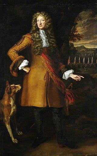
John Russell (1620–1687) was an English soldier and politician who sat in the House of Commons from 1641 to 1644. He fought in the Royalist army during the English Civil War.
Tavistock Street is a street in the Covent Garden area of London which runs parallel to the Strand between Drury Lane and Southampton Street just south of the market piazza.

The Old Bell is a Grade II listed public house at 16 Exeter Street and 23 Wellington Street, Covent Garden, London, WC2.

The Nell Gwynne Tavern is a Grade II listed public house at 1–2 Bull Inn Court, Covent Garden, London, WC2.

The Cheshire Cheese is a public house at 5 Little Essex Street, London WC2, on the corner with Milford Lane.

Milford Lane is a narrow street in the City of Westminster that runs from Strand in the north to a brief walkway section leading to Temple Place in the south. It is joined by Little Essex Street and Essex Street on its eastern side. Maltravers Street once joined the lane to Arundel Street, but ceased to exist when building work at 190 Strand was completed.
This is a list of the etymology of street names in the London district of Covent Garden. Covent Garden has no formally defined boundaries – those utilised here are: Shaftesbury Avenue to the north-west, New Oxford Street and High Holborn to the north, Kingsway and the western half of the Aldwych semi-circle to the east, Strand to the south and Charing Cross Road to the west.
