
Plymouth is a port city and unitary authority in South West England. It is located on the south coast of Devon, approximately 36 miles (58 km) south-west of Exeter and 193 miles (311 km) south-west of London. It is bordered by Cornwall to the west and south-west.

Plymouth Sound, or locally just The Sound, is a deep Inlet or sound in the English Channel near Plymouth in England.

The Torpoint Ferry is a car and pedestrian chain ferry connecting the A374 which crosses the Hamoaze, a stretch of water at the mouth of the River Tamar, between Devonport in Plymouth and Torpoint in Cornwall. The service was established in 1791 and chain ferry operations were introduced by James Meadows Rendel in 1832.

The River Plym is a river in Devon, England. It runs from Dartmoor in the centre of the county southwest to meet the River Meavy, then south towards Plymouth Sound. The river is popular with canoeists, and the Plym Valley Railway runs alongside a section of the river.

The Tamar is a river in south west England, that forms most of the border between Devon and Cornwall. A part of the Tamar valley is a World Heritage Site due to its historic mining activities.
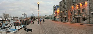
The Barbican is the name given to the western and northern sides of Sutton Harbour, the original harbour of Plymouth in Devon, England. It was one of the few parts of the city to escape most of the destruction of The Blitz during the Second World War and the preceding era of slum clearance following the Public Health Act 1848. Two or three streets still retain some of the architecture of a historic fishing port. The Barbican has the largest concentration of cobbled streets in Britain and contains 100 listed buildings.

Duck's Pool is a small depression set in a remote location in the southern half of Dartmoor, Devon, England at grid reference SX624678. It lies between the sources of the River Plym and the River Erme.

Plymstock is a commuter suburb of Plymouth and former civil parish in the English county of Devon.

The Erme is a river in south Devon, England. From its source on Dartmoor it flows in a generally southerly direction past some of the best-preserved archaeological remains on the moor. It leaves the moor at the town of Ivybridge and continues southward, passing the settlements of Ermington, Modbury and Holbeton. Near Holbeton it becomes a ria and empties into the English Channel in Bigbury Bay, between the rivers Yealm and Avon.

Mount Batten is a 24-metre (80-ft) tall outcrop of rock on a 600-metre (2000-ft) peninsula in Plymouth Sound, Devon, England, named after Sir William Batten (c.1600-1667), MP and Surveyor of the Navy; it was previously known as How Stert.
Oreston, formerly a village on the southern bank of the Cattewater, is now a suburb of Plymouth. It is recorded as Horestone on the 1591 Spry Map of Plimmouth. Oreston offers many small, local services. It is home to a small cornershop style shop called "The Quay News," a pub called "The King's Arms," a small dock and free public slipway in "Oreston Quay," and is home to approximately 3,000 residents.
Cattewater Wreck is a wooden three-masted, skeleton-built vessel, one of many ships that have wrecked in Cattewater, Plymouth Sound, England. This wreck is close to the entrance of Sutton Harbour, its name is still unknown but it is believed to be from the 16th Century. It is a Protected Wreck managed by Historic England.

Millbay, also known as Millbay Docks, is an area of dockland in Plymouth, Devon, England. It lies south of Union Street, between West Hoe in the east and Stonehouse in the west. The area is currently subject to a public-private regeneration creating new homes, business premises, marina, a 1000-pupil school and opening up the waterfront to greater public access.

The network of railways in Plymouth, Devon, England, was developed by companies affiliated to two competing railways, the Great Western Railway and the London and South Western Railway. At their height two main lines and three branch lines served 28 stations in the Plymouth area, but today just six stations remain in use.

Plymouth Friary railway station was the London and South Western Railway (LSWR) terminus in Plymouth, Devon, England.

The History of Plymouth in Devon, England, extends back to the Bronze Age, when the first settlement began at Mount Batten a peninsula in Plymouth Sound facing onto the English Channel. It continued as both a fishing and continental tin trading port through the late Iron Age into the Early Medieval period, until the more prosperous Saxon settlement of Sutton, later renamed Plymouth, surpassed it. With its natural harbour and open access to the Atlantic, the town found wealth and a national strategic importance during the establishment of British naval dominance in the colonisation of the New World. In 1620 the Pilgrim Fathers departed from Plymouth to establish the second English colony in America. During the English Civil War the town was besieged between 1642 and 1646 by the Royalists, but after the Restoration a Dockyard was established in the nearby town of Devonport. Throughout the Industrial Revolution Plymouth grew as a major mercantile shipping industry, including imports and passengers from the US, whilst Devonport grew as a naval base and ship construction town, building battleships for the Royal Navy – which later led to its partial destruction during World War II in a series of air-raids known as the Plymouth Blitz. After the war was over, the city centre was completely rebuilt to a new plan.
The Plymouth and Dartmoor Railway (P&DR) was a 4 ft 6 in gauge railway built to improve the economy of moorland areas around Princetown in Devon, England. Independent carriers operated horse-drawn wagons and paid the company a toll. It opened in 1823, and a number of short branches were built in the next few years.

The Turnchapel Branch was a London and South Western Railway (LSWR) single track branch railway line in Devon, England, that ran from Plymouth Friary station to Turnchapel. It crossed the River Plym and opened up the east side of the river to rail connections. The short line opened in 1892 and 1897 (throughout). It closed in 1951 to passengers, and in 1961 completely.
Shaugh Prior is a village and civil parish on the south-western side of Dartmoor in the county of Devon, England. It is situated about 8 miles north-east of the historic centre of the city of Plymouth. In 2001 its population was 751. The parish stretches from the edge of Plymouth to the high moorland of Dartmoor. The River Plym forms its western and northern boundaries up to the river's source at Plym Head. The higher parts of the parish are rich in Bronze Age monuments such as cists and cairns, and there is much evidence of tin mining. The area of Lee Moor that has been much mined for china clay is within the parish, but outside the Dartmoor National Park.

The fortifications of Plymouth in Devon are extensive due to its natural harbour, its commanding position on the Western Approaches and its role as the United Kingdom's second largest naval base after Portsmouth. The first medieval defences were built to defend Sutton Harbour on the eastern side of Plymouth Sound at the mouth of the River Plym, but by the 18th century, naval activity had begun to shift westward to Devonport at the mouth of the River Tamar. During the Victorian era, advances in military technology led to a huge programme of fortification encompassing the whole of Plymouth Sound together with the overland approaches. Many of these works remained in military use well into the 20th century.
