
Plymouth is a port city and unitary authority in South West England. It is located on the south coast of Devon, approximately 37 miles (60 km) south-west of Exeter and 190 miles (310 km) south-west of London. It is bordered by Cornwall to the west and south-west.

Plymouth Sound, or locally just The Sound, is a deep Inlet or sound in the English Channel near Plymouth in England.

Newlyn is a seaside town and fishing port in south-west Cornwall, UK.
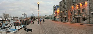
The Barbican is the name given to the western and northern sides of Sutton Harbour, the original harbour of Plymouth in Devon, England. It was one of the few parts of the city to escape most of the destruction of The Blitz during the Second World War and the preceding era of slum clearance following the Public Health Act 1848. Two or three streets still retain some of the architecture of a historic fishing port. The Barbican has the largest concentration of cobbled streets in Britain and contains 100 listed buildings.

Portsmouth Harbour is a 1,264.2-hectare (3,124-acre) biological Site of Special Scientific Interest between Portsmouth and Gosport in Hampshire. It is a Ramsar site and a Special Protection Area.

Plymouth City Airport is a 'mothballed' airport located within the City of Plymouth 3.5 NM north northeast of the city centre in Devon, England at Derriford. The airport opened on this site in 1925 and was officially opened by the future Edward VIII, as Prince of Wales, in 1931.

The National Marine Aquarium, located in Britain’s Ocean City Plymouth is the largest Aquarium in the UK. Home to over 4,000 animals and groundbreaking Ocean conservation work. Offering a variety of immersive and engaging opportunities to learn about the marine environment through ocean education for all ages.
The Port of Dives-sur-Mer, Port de Dives-sur-Mer, is the harbour of the Norman town of Dives-sur-Mer, France. It is from this harbour that William the Conqueror left for England to claim the throne.

Millbay, also known as Millbay Docks, is an area of dockland in Plymouth, Devon, England. It lies south of Union Street, between West Hoe in the east and Stonehouse in the west. The area is currently subject to a public-private regeneration creating new homes, business premises, marina, a 1000-pupil school and opening up the waterfront to greater public access.

The Port of Southampton is a passenger and cargo port in the central part of the south coast of England. The modern era in the history of the Port of Southampton began when the first dock was inaugurated in 1843. The port has been owned and operated by Associated British Ports since 1982, and is the busiest cruise terminal and second largest container port in the UK.

The History of Plymouth in Devon, England, extends back to the Bronze Age, when the first settlement began at Mount Batten a peninsula in Plymouth Sound facing onto the English Channel. It continued as both a fishing and continental tin trading port through the late Iron Age into the Early Medieval period, until the more prosperous Saxon settlement of Sutton, later renamed Plymouth, surpassed it. With its natural harbour and open access to the Atlantic, the town found wealth and a national strategic importance during the establishment of British naval dominance in the colonisation of the New World. In 1620 the Pilgrim Fathers departed from Plymouth to establish the second English colony in America. During the English Civil War the town was besieged between 1642 and 1646 by the Royalists, but after the Restoration a Dockyard was established in the nearby town of Devonport. Throughout the Industrial Revolution Plymouth grew as a major mercantile shipping industry, including imports and passengers from the US, whilst Devonport grew as a naval base and ship construction town, building battleships for the Royal Navy – which later led to its partial destruction during World War II in a series of air-raids known as the Plymouth Blitz. After the war was over, the city centre was completely rebuilt to a new plan.

The Marine Biological Association of the United Kingdom (MBA) is a learned society with a scientific laboratory that undertakes research in marine biology. The organisation was founded in 1884 and has been based in Plymouth since the Citadel Hill Laboratory was opened on 30 June 1888.

The Port of Lowestoft is a harbour in Lowestoft in the English county of Suffolk owned by Associated British Ports. It is the most easterly harbour in the United Kingdom and has direct sea access to the North Sea. The harbour is made up of two sections divided by a bascule bridge. The inner harbour is formed by Lake Lothing whilst the outer harbour is constructed from breakwaters.

Fishing in Cornwall, England, UK, has traditionally been one of the main elements of the economy of the county. Pilchard fishing and processing was a thriving industry in Cornwall from around 1750 to around 1880, after which it went into an almost terminal decline. During the 20th century the varieties of fish taken became much more diverse and crustaceans such as crab and lobster are now significant. Much of the catch is exported to France due to the higher prices obtainable there. Though fishing has been significantly damaged by overfishing, the Southwest Handline Fishermen's Association has started to revive the fishing industry. As of 2007, stocks are improving. The Cornwall Sea Fisheries Committee is one of 12 such committees responsible for managing the corresponding Sea Fisheries District. The Isles of Scilly Sea Fisheries Committee is responsible for the Scilly district.
Nanaimo Harbour is a natural harbour on the east coast of Vancouver Island, British Columbia, Canada. The City of Nanaimo runs along the west side of the harbour. Three islands, Newcastle, Protection, and Gabriola, along with Duke Point form the eastern edge. The Nanaimo River estuary dominates the southern end of the harbour.

The Port of Skagen, also Skagen Harbour, is located in Skagen, northern Denmark. The country's leading fishing port consists of an industrial harbour that supports the area's fishing industry as well as facilities for cruise ships. It also has a shipyard and fish-processing facilities. The harbour's marina is open to visitors during the summer months.

Roscoff is a town situated on the north coast of Finistère, Brittany. Its favorable position at the western end of the channel along with the efforts of the economic administrators have allowed the port to survive and develop itself within the different fields surrounding the sea. Amongst the 13 main Breton ports, Roscoff is one of the largest commercial harbours on the list.

Plymouth Castle was a castle built in the early 15th century to defend the town and harbour of Plymouth in Devon, England. By the end of the 16th century it had ceased to have any military function and fell into disrepair, being almost completely demolished by the 19th century. Only a small fragment of an outer gatehouse remains.

The fortifications of Plymouth in Devon are extensive due to its natural harbour, its commanding position on the Western Approaches and its role as the United Kingdom's second largest naval base after Portsmouth. The first medieval defences were built to defend Sutton Harbour on the eastern side of Plymouth Sound at the mouth of the River Plym, but by the 18th century, naval activity had begun to shift westward to Devonport at the mouth of the River Tamar. During the Victorian era, advances in military technology led to a huge programme of fortification encompassing the whole of Plymouth Sound together with the overland approaches. Many of these works remained in military use well into the 20th century.

The Yorkshire coast fishery has long been part of the Yorkshire economy for centuries. The 114 miles (183 km) Yorkshire Coast, from the River Tees to the River Humber, has many ports both small and large where sea catch was landed. The historic ports at Hull and Whitby are important locations for the landing and processing of fish and shellfish. Scarborough and Bridlington are also sites of commercial fishing.


