Mount Batten

Last updated

Mount Batten from Plymouth Hoe Mountbattenpeninsula.JPG
Mount Batten from Plymouth Hoe

Mount Batten is a 24-metre (80-ft) tall outcrop of rock on a 600-metre (2000-ft) peninsula in Plymouth Sound, Devon, England, named after Sir William Batten [1] (c.1600-1667), MP and Surveyor of the Navy; it was previously known as How Stert. [1]

Contents

After some redevelopment which started with the area coming under the control of the Plymouth Development Corporation for five years from 1993, the peninsula now has a marina and centre for sea sport.

The Mount Batten Breakwater (also referred to as Cattewater Breakwater and, incorrectly, Mount Batten Pier) to the west doubles as a breakwater for the Cattewater and Sutton Harbour. It was built in 1881 by the Cattewater Commissioners and subsequently refurbished by the Plymouth Development Corporation opening formally in 1995. The unveiling of the plaque by opening of a temporary curtain during the 1995 re-opening ceremony was done so by Tim Fulfit (age 10 at the time) who was a pupil selected from the local Hooe Primary School. [ citation needed ]

Mount Batten breakwater Mount Batten.JPG
Mount Batten breakwater

History

Early history

According to excavations reported by Barry Cunliffe in 1988, Mount Batten was the site of the earliest trade with Europe yet discovered in Bronze Age Britain, operating from the late Bronze Age, peaking in the late Iron Age Britain and continuing in operation throughout the Roman period. [2] [3] [4] It appears to have been the primary route of entry to Bronze Age Britain for large quantities of continental commodities such as wine, and is therefore a speculative candidate for the trading centre of 'Ictis' reported by Diodorus Siculus [5] and for the 'Tamaris' of Ptolemy's Geographia. [6] Three fine British-made bronze mirrors were excavated on the peninsula, among many other ancient finds, but were lost in the Plymouth Blitz. [7]

Coastal erosion

Before the Plymouth Breakwater was completed in 1841 and the Mount Batten Breakwater in 1881, the Mount Batten peninsula was subject to significant coastal erosion. In the 17th century, maintenance of the Cattewater required annual removal of silt and rubble which was dumped on the south side of Mount Batten.[ citation needed ] However, in 1633 and 1634 the Mount Batten isthmus was breached.[ citation needed ] A sea wall was built to resolve the problem but it wasn't until the breakwaters were built that the problem was finally solved.[ citation needed ]

Mount Batten Tower

Mount Batten Tower Mount Batten Tower.jpg
Mount Batten Tower

In the later Medieval period, Mount Batten became an important defensive point for the developing settlement at Plymouth Harbour, providing a field of fire from across the other side of the Cattewater, the channel connecting the old town to the sea. In 1652, Mount Batten Tower, a 30-foot high circular artillery fort was built here; it is a Scheduled Ancient Monument.

Maritime incidents

In 1973, a short distance from Mount Batten, the Cattewater Wreck was discovered during dredging. Subsequent survey and excavation work indicated that the wreck was of a 200–300 ton merchantmen believed to have been lost in the early 16th Century. It has the distinction of being the first wreck to be protected under the Protection of Wrecks Act 1973. On 16 February 1811, the frigate HMS Amethyst wrecked on the ground near Cony Cliff Rocks, Mount Batten. Eight seamen lost their lives.[ citation needed ]

Quarrying at Mount Batten

Extensive quarrying took place at Mount Batten between 1839 and the mid-1860s. [8] Stones from the quarry were used for building steam yards at HMNB Devonport. The quarrying substantially changed the local landscape and threatened the Mount Batten Tower. Following a petition from 53 leading citizens to the Admiralty, Lord Morley, the landowner, imposed restrictions on quarrying thereby saving the tower.[ citation needed ]

Mount Batten Breakwater

Mount Batten Breakwater during storm Mount Batter Breakwater during storm on 3 Jan 2012.JPG
Mount Batten Breakwater during storm

Work on the Mount Batten Breakwater [9] (also referred to as Mount Batten Pier and Cattewater Breakwater) started in 1878 and was completed in 1881 at a total cost of £20,000. It is 915 feet (279 metres) in length and the foundations are 20 feet (6 metres) below the low tide mark. The breakwater was promoted by the Cattewater Commissioners who were responsible for shipping in the area. During the air-station years the breakwater was closed to the public and used, for a period, to store flying boats. In 1995 the breakwater was refurbished and re-opened to the public.

The breakwater is a popular site for local anglers and for those watching ships using the Plymouth Sound. Boats in the Fastnet and Americas Cup, can also be viewed. In August each year, the breakwater is used for the British Firework Championships.

Early tourism

The coastal walk to Jennycliff and local inns, originally built to service those working on the quarries, helped make Mount Batten an increasingly popular destination for Plymothians. During one bank holiday in 1906, some 10,000 visitors took the ferry to the area. This fledgling tourist industry came to an abrupt end when the area was closed to the public.

The air-station years (1913–1986)

Seaplane trials first took place around Mount Batten as early as 1913 and an air-station was subsequently developed. A local commemorative display poster cites the following names and years for the air station:

Between 1917 and 1945, with some gaps, it was a flying boat base for both the Royal Air Force and the Royal Navy. The RAF operated search and rescue launches from the base. T. E. Lawrence was stationed there under the moniker Aircraftsman Shaw. [10]

Shorts Sunderland flying boats of the Royal Australian Air Force operated from RAF Mount Batten during World War II, taking part in the Battle of the Atlantic. The RAF finally left in 1986.

Recent history

The former RAF Mount Batten site was transferred to the Plymouth Development Corporation in 1992.

In 1999, the Mount Batten Sailing and Watersports Centre opened on the site of the former sergeants' mess. The peninsula is also home to a small residential community with 22 houses, Spinnaker Quay, dating from 2001.

Related Research Articles

<span class="mw-page-title-main">Plymouth Sound</span> Bay

Plymouth Sound, or locally just The Sound, is a deep inlet or sound in the English Channel near Plymouth in England.

<span class="mw-page-title-main">Rhins of Galloway</span> Peninsula in Scotland

The Rhinsof Galloway is a double-headed peninsula in southwestern Scotland. It takes the form of a hammerhead projecting into the Irish Sea, terminating in the north at Corsewall and Milleur Points and in the south at the Mull of Galloway. It is connected to the rest of Wigtownshire by an isthmus, washed on the north by Loch Ryan and on the south by Luce Bay. From end to end, the peninsula measures 28 miles. It takes its name from the Gaelic word rinn, meaning "point".

<span class="mw-page-title-main">Saro London</span> British flying boat built from 1934

The Saunders Roe A.27 London was a British military biplane flying boat built by the Saunders Roe company. Only 31 were built, entering service with the Royal Air Force (RAF) in 1936. Although due for replacement by the outbreak of World War II, they saw some active service pending the introduction of the ultimately unsuccessful Lerwick.

SS Torrey Canyon was an LR2 Suezmax class oil tanker with a cargo capacity of 118,285 long tons (120,183 t) of crude oil. She ran aground off the western coast of Cornwall, United Kingdom, on 18 March 1967, causing an environmental disaster. At that time she was the largest vessel ever to be wrecked.

<span class="mw-page-title-main">Cattewater</span>

The city of Plymouth, Devon, England is bounded by Dartmoor to the north, the Hamoaze to the west, the open expanse of water called Plymouth Sound to the south and the river Plym to the east.

<span class="mw-page-title-main">Blackburn Iris</span> Type of aircraft

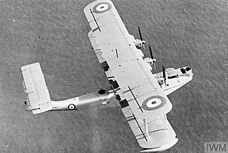
The Blackburn Iris was a British three-engined biplane flying boat of the 1920s. Although only five Irises were built, it was used as a long-range maritime reconnaissance aircraft by the Royal Air Force, where it equipped a squadron for four years, being used to carry out a number of notable long-distance flights. The final version of the Iris, the Iris Mark V was developed into the aircraft that replaced it in Squadron service, the Blackburn Perth.

Cattewater Wreck is a wooden three-masted, skeleton-built vessel, one of many ships that have wrecked in Cattewater, Plymouth Sound, England. This wreck is close to the entrance of Sutton Harbour, its name is still unknown but it is believed to be from the 16th Century. It is a Protected Wreck managed by Historic England.

<span class="mw-page-title-main">Blackburn Perth</span> 1933 flying boat

The Blackburn Perth was a British flying boat which was in service during the interwar period. It was essentially an upgraded Iris, and hence the largest flying-boat to serve with the Royal Air Force at the time.

<span class="mw-page-title-main">Gerald Livock</span>

Group Captain Gerald Edward Livock was an English officer of the Royal Naval Air Service and Royal Air Force, who served from the beginning the First World War until the end of Second, and was also an archaeologist and cricketer. A right-handed batsman and wicket-keeper, he played first-class cricket for various teams between 1923 and 1934.

No. 204 Squadron was a Royal Air Force unit first formed in March 1915 as No.4 Squadron Royal Naval Air Service.

<span class="mw-page-title-main">British Firework Championships</span> Annual fireworks competition held in Plymouth, England

The British Firework Championships or National Firework Championships is an annual competition held in Plymouth, Devon, England, every August where judges review fireworks displays from professional fireworks companies and select the best examples.

<span class="mw-page-title-main">History of Plymouth</span> History of the city in Devon, England

The History of Plymouth in Devon, England, extends back to the Bronze Age, when the first settlement began at Mount Batten a peninsula in Plymouth Sound facing onto the English Channel. It continued as both a fishing and continental tin trading port through the late Iron Age into the Early Medieval period, until the more prosperous Saxon settlement of Sutton, later renamed Plymouth, surpassed it. With its natural harbour and open access to the Atlantic, the town found wealth and a national strategic importance during the establishment of British naval dominance in the colonisation of the New World. In 1620 the Pilgrim Fathers departed from Plymouth to establish the second English colony in America. During the English Civil War the town was besieged between 1642 and 1646 by the Royalists, but after the Restoration a Dockyard was established in the nearby town of Devonport. Throughout the Industrial Revolution Plymouth grew as a major mercantile shipping industry, including imports and passengers from the US, whilst Devonport grew as a naval base and ship construction town, building battleships for the Royal Navy – which later led to its partial destruction during World War II in a series of air-raids known as the Plymouth Blitz. After the war was over, the city centre was completely rebuilt to a new plan.

<span class="mw-page-title-main">RAF Mount Batten</span> Former Royal Air Force station and flying boat base in Devon, England

Royal Air Force Mount Batten, or more simply RAF Mount Batten, is a former Royal Air Force station and flying boat base at Mount Batten, a peninsula in Plymouth Sound, Devon, England, UK. Originally a seaplane station opened in 1917 as a Royal Navy Air Service Station Cattewater it became RAF Cattewater in 1918 and in 1928 was renamed RAF Mount Batten. The base is named after Captain Batten, a Civil War commander who defended this area at the time, with the Mountbatten family motto In Honour Bound taken as the station's motto.

RNAS Tresco was a Royal Naval Air Service base on Tresco, the second largest island in the Isles of Scilly. From February 1917 to May 1919 aircraft patrolled the Western Approaches and provided an escort for convoys. A total of thirteen U-boats were sighted and nine attacked.

<span class="mw-page-title-main">Ictis</span>

Ictis, or Iktin, is or was an island described as a tin trading centre in the Bibliotheca historica of the Sicilian-Greek historian Diodorus Siculus, writing in the first century BC.

<span class="mw-page-title-main">Royal Air Force Marine Branch</span> Air-sea rescue service

The Marine Branch (1918–1986) was a branch of the Royal Air Force (RAF) which operated watercraft in support of RAF operations. Just days after the creation of the RAF itself, the Marine Craft Section (MCS) was created with the transfer of Royal Naval Air Service (RNAS) vessels and personnel to the new service. Originally tasked with the support of RNAS, and later RAF, seaplanes, Marine Craft Section was to achieve its greatest size during the Second World War, and achieved fame for its role in air-sea rescue operations. After the war MCS was granted full branch status on 11 December 1947; however, post-war the role of the new branch became greatly reduced with the end of the British Empire, the withdrawal of flying boats from service, and the increasing use of helicopters in air-sea rescue. The branch was disestablished on 8 January 1986.

<span class="mw-page-title-main">Fortifications of Plymouth</span>

The fortifications of Plymouth in Devon are extensive due to its natural harbour, its commanding position on the Western Approaches and its role as the United Kingdom's largest naval base. The first medieval defences were built to defend Sutton Harbour on the eastern side of Plymouth Sound at the mouth of the River Plym, but by the 18th century, naval activity had begun to shift westward to Devonport at the mouth of the River Tamar. During the Victorian era, advances in military technology led to a huge programme of fortification encompassing the whole of Plymouth Sound together with the overland approaches. Many of these works remained in military use well into the 20th century.

<span class="mw-page-title-main">No. 19 Group RAF</span> Former Royal Air Force operations group

No. 19 Group was a group of the Royal Air Force, active during 1918, and then from 1941-1969.

Mount Batten is an outcrop of rock on a peninsula in Plymouth Sound, Devon, England, named after Sir William Batten.

References

  1. 1 2 Photiou, Philip (2005). Plymouth's Forgotten War: The Great Rebellion, 1642-1646. p. 241. ISBN   0-7223-3669-1.
  2. "Mount Batten: prehistoric and Romano-British settlement, Non Civil Parish - 1017598 | Historic England". historicengland.org.uk. Retrieved 25 August 2021.
  3. Barry Cunliffe : Mount Batten Plymouth: A Prehistoric and Roman Port. Oxford University Press 1988
  4. Cunliffe, Barry (1982). "Britain, the Veneti and beyond. 1982". Oxford Journal of Archaeology. 1 (1): 39–68. doi:10.1111/j.1468-0092.1982.tb00298.x.
  5. Miranda Jane Aldhouse-Green, The Celtic World (1996), p. 276
  6. "Tamaris – Probable Settlement and Port". www.Roman-Britain.co.uk. July 2004. Archived from the original on 11 August 2008. Retrieved 22 August 2008.
  7. "Celtic Mirrors".
  8. Gerald Wasley: Mount Batten- The Flying Boats of Plymouth, Halsgrove, 2006
  9. Moseley, Brian (19 January 2011). "Mount Batten Breakwater". The Encyclopaedia of Plymouth History. Archived from the original on 3 December 2013. Retrieved 12 February 2015.
  10. Beauforte-Greenwood, W. E. G. "Notes on the introduction to the RAF of high-speed craft". T. E. Lawrence Studies. Retrieved 11 April 2011.

50°21′34″N4°07′47″W / 50.35944°N 4.12972°W / 50.35944; -4.12972