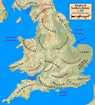
While Ictis is widely accepted to have been an island somewhere off the southern coast of what is now England, scholars continue to debate its precise location. Candidates include St Michael's Mount and Looe Island off the coast of Cornwall, the Mount Batten peninsula in Devon, and the Isle of Wight further to the east.
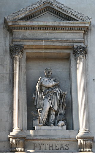
Diodorus Siculus, who flourished between about 60 and about 30 BC, is supposed to have relied for his account of the geography of Britain on a lost work of Pytheas, a Greek geographer from Massalia who made a voyage around the coast of Britain near the end of the fourth century BC, searching for the source of amber. The record of the voyage of Pytheas was lost in antiquity but was known to some later writers, including Timaeus, Posidonius, and Pliny the Elder. Their work is contradictory, but from it deductions can be made about what was reported by Pytheas. This “represents all that was known about the tin trade in the ancient classical world”.[1]
Diodorus gives an account that is generally supposed to be a description of the working of Cornish tin at about the time of the voyage of Pytheas. He says:
The inhabitants of that part of Britain which is called Belerion are very fond of strangers and from their intercourse with foreign merchants are civilized in their manner of life. They prepare the tin, working very carefully the earth in which it is produced. The ground is rocky but it contains earthy veins, the produce of which is ground down, smelted and purified. They beat the metal into masses shaped like knuckle-bones and carry it off to a certain island off Britain called Iktis. During the ebb of the tide the intervening space is left dry and they carry over to the island the tin in abundance in their wagons... Here then the merchants buy the tin from the natives and carry it over to Gaul, and after travelling overland for about thirty days, they finally bring their loads on horses to the mouth of the Rhone.[1]
In the Greek text of Diodorus the name appears, in the accusative case, as "Iktin", so that translators have inferred that the nominative form of the name was "Iktis", rendering this into the medieval lingua franca of Latin (which only rarely used the letter 'k') as "Ictis". However, some commentators doubt that "Ictis" is correct and prefer "Iktin".[2]
In Book IV of his Natural History, Pliny quotes Timaeus and refers to "insulam Mictim" (the island of Mictis, or perhaps of Mictim):
There is an island named Mictis lying inwards six days' sail from Britain, where tin is found, and to which the Britons cross in boats of wickerwork covered with stitched hides.[3]
It has been suggested that "insulam Mictim" was a copying error for insulam Ictim, and Diodorus and Pliny probably both relied on the same primary source. However, while it is possible that "Mictim" and "Iktin" are one and the same, it is also possible that they are different places. The word "inwards" (introrsus) can be interpreted as meaning "towards our home", and six days' sail from Britain could take a boat to somewhere on the Atlantic coast of what is now France.[4]
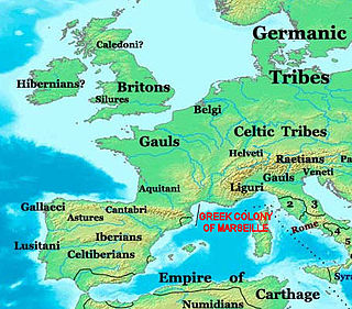
Strabo, a contemporary of Diodorus, stated in his Geography that British tin was shipped from Massalia on the Mediterranean coast of Gaul.[5]
Julius Caesar, in his De Bello Gallico, says of the Veneti: "This last-named people were by far the most powerful on the coast of Armorica: they had a large fleet plying between their own ports and Britain; they knew more about the handling of ships and the science of navigation than anyone else thereabouts."[6]
William Camden, the Elizabethan historian, took the view that the name "Ictis" was so similar to "Vectis", the Latin name for the Isle of Wight, that the two were probably the same island. The Cornish antiquary William Borlase (1696–1772) suggested that Ictis must have been near the coast of Cornwall and could have been a general name for a peninsula there.[7]
In 1960, Gavin de Beer concluded that the most likely location of Iktin (the form of the name he preferred) was St Michael's Mount, a tidal island near the town of Marazion in Cornwall. Apart from the effect of the tide being consistent with what is said by Diodorus, de Beer considered the other benefits of St Michael's Mount for the Britons.[2] This identification is supported by the Roman Britain website.[1]
In 1972, I. S. Maxwell weighed up the competing claims of no fewer than twelve possible sites.[8] In 1983, after excavations, the archaeologist Barry W. Cunliffe proposed the Mount Battenpeninsula near Plymouth as the site of Ictis.[3] Near the mouth of the River Erme, not far away, a shipwreck site has produced ingots of ancient tin, which indicates a trade along the coast, although dating the site is difficult and it may not belong to the Bronze Age.[9]
The two places considered most likely to be Ictis are the island of St Michael's Mount, Cornwall, and the peninsula of Mount Batten in Plymouth Sound (Cunliffe 1983; Hawkes 1984)... Mount Batten seems archaeologically more likely as there are a number of finds from there which indicate it was prominent in international trade from the fourth century BC until the first century AD (Cunliffe 1988).[10]
1 2 Gavin de Beer, "Iktin", in The Geographical Journal vol. 126 (June 1960) pp. 160–167, at p. 162
1 2 Barry W. Cunliffe, "Ictis: Is it here?" in Oxford Journal of Archaeology, vol. 2, issue 1 (March 1983), pp. 123–126 (see abstract)
↑ Barry Cunliffe, "Exchanges with the wider world" in Iron age communities in Britain: an account of England, Scotland, and Wales from the seventh century BC until the Roman conquest (Routledge, 1978) p. 471
↑ Gaius Julius Caesar, Caesar's War Commentaries (Kessinger, 2004), pp. 45–46
↑ Sir Christopher Hawkins, Observations on the tin trade of the ancients in Cornwall (1811), p. 63: "Mr. Camden supposes, that, from the similarity of the words Ictis and Vectis, it was one and the same island. Dr. Borlase says, that the Ictis must have been situated somewhere near the Coast of Cornwall, and have been a general name for a peninsula, or some particular peninsula, and common emporium, on the same coast."
↑ I. S. Maxwell, "The location of Ictis" in Journal of the Royal Institution of Cornwall 6 (4), pp. 293–319
S. Mitchell, Cornish tin, Julius Caesar, and the invasion of Britain (1983)
Christopher F. C. Hawkes, 'Ictis disentangled and the British tin trade' in Oxford Journal of Archaeology, 3 (1984), pp. 211–233
R. D. Penhallurick, Tin in Antiquity (London, 1986)
Related Research Articles
Cornwall is a ceremonial county in South West England. It is recognised by Cornish and Celtic political groups as one of the Celtic nations, and is the homeland of the Cornish people. The county is bordered by the Atlantic Ocean to the north and west, Devon to the east, and the English Channel to the south. The largest settlement is Falmouth, and the county town is the city of Truro.
The Dumnonii or Dumnones were a British tribe who inhabited Dumnonia, the area now known as Cornwall and Devon in the further parts of the South West peninsula of Britain, from at least the Iron Age up to the early Saxon period. They were bordered to the east by the Durotriges tribe.
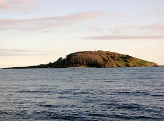
Looe Island, also known as St George's Island, and historically St Michael's Island is a small island nature reserve a mile from the mainland town of Looe off Cornwall, England.
Pytheas of Massalia was a Greek geographer, explorer and astronomer from the Greek colony of Massalia. He made a voyage of exploration to northwestern Europe in about 325 BC, but his account of it, known widely in antiquity, has not survived and is now known only through the writings of others.
Burgh Island is a tidal island on the coast of South Devon in England near the small seaside village of Bigbury-on-Sea. There are several buildings on the island, the largest being the Art Deco Burgh Island Hotel. The other buildings are three private houses, and a pub, the Pilchard Inn, which dates to the 14th century. The island is strongly associated with writer Agatha Christie, who often visited and used the island and its hotel as a setting and inspiration for two famous novels: And Then There Were None (1939) and Evil Under the Sun (1941).
In ancient times, Armorica or Aremorica was a region of Gaul between the Seine and the Loire that includes the Brittany Peninsula, extending inland to an indeterminate point and down the Atlantic Coast.
Dumnonia is the Latinised name for a Brythonic kingdom that existed in Sub-Roman Britain between the late 4th and late 8th centuries CE in the more westerly parts of present-day South West England. It was centred in the area of modern Devon, but also included modern Cornwall and part of Somerset, with its eastern boundary changing over time as the gradual westward expansion of the neighbouring Anglo-Saxon kingdom of Wessex encroached on its territory. The spelling Damnonia is sometimes encountered, but that spelling is also used for the land of the Damnonii, later part of the Kingdom of Strathclyde, in present-day southern Scotland. The form Domnonia also occurs. The name of the kingdom shares a linguistic relationship with the Breton region of Domnonée.
St Michael's Mount is a tidal island in Mount's Bay, Cornwall, England, United Kingdom. The island is a civil parish and is linked to the town of Marazion by a causeway of granite setts, passable between mid-tide and low water. It is managed by the National Trust, and the castle and chapel have been the home of the St Aubyn family since around 1650.
The history of Cornwall goes back to the Paleolithic, but in this period Cornwall only had sporadic visits by groups of humans. Continuous occupation started around 10,000 years ago after the end of the last ice age. When recorded history started in the first century BCE, the spoken language was Common Brittonic, and that would develop into Southwestern Brittonic and then the Cornish language. Cornwall was part of the territory of the tribe of the Dumnonii that included modern-day Devon and parts of Somerset. After a period of Roman rule, Cornwall reverted to rule by independent Romano-British leaders and continued to have a close relationship with Brittany and Wales as well as southern Ireland, which neighboured across the Celtic Sea. After the collapse of Dumnonia, the remaining territory of Cornwall came into conflict with neighbouring Wessex.
The British Iron Age is a conventional name used in the archaeology of Great Britain, referring to the prehistoric and protohistoric phases of the Iron Age culture of the main island and the smaller islands, typically excluding prehistoric Ireland, which had an independent Iron Age culture of its own. The Iron Age is not an archaeological horizon of common artefacts but is rather a locally-diverse cultural phase.
Mount Batten is a 24-metre (80-ft) tall outcrop of rock on a 600-metre (2000-ft) peninsula in Plymouth Sound, Devon, England, named after Sir William Batten (c.1600-1667), MP and Surveyor of the Navy; it was previously known as How Stert.
The Venetī were a Gallic tribe dwelling in Armorica, in the southern part of the Brittany Peninsula, during the Iron Age and the Roman period.
The Cassiterides are an ancient geographical name used to refer to a group of islands whose precise location is unknown, but which was believed to be situated somewhere near the west coast of Europe.
Baltia, Basilia or Abalus is a mythic island in northern Europe mentioned in Greco-Roman geography in the connection of amber.
Mining in Cornwall and Devon, in the southwest of Britain, is thought to have begun in the early-middle Bronze Age with the exploitation of cassiterite. Tin, and later copper, were the most commonly extracted metals. Some tin mining continued long after the mining of other metals had become unprofitable, but ended in the late 20th century. In 2021, it was announced that a new mine was extracting battery-grade lithium carbonate, more than 20 years after the closure of the last South Crofty tin mine in Cornwall in 1998.
Bouldnor is a hamlet near Yarmouth on the west coast of the Isle of Wight in southern England. It is the location of Bouldnor Battery, a gun battery emplacement.
The name Britain originates from the Common Brittonic term *Pritanī and is one of the oldest known names for Great Britain, an island off the north-western coast of continental Europe. The terms Briton and British, similarly derived, refer to some or all of its inhabitants and, to varying extents, those of the smaller islands in the vicinity. "British Isles" is the only ancient name for these islands to survive in general usage.
The Greeks in pre-Roman Gaul have a significant history of settlement, trade, cultural influence, and armed conflict in the Celtic territory of Gaul, starting from the 6th century BC during the Greek Archaic period. Following the founding of the major trading post of Massalia in 600 BC by the Phocaeans at present day Marseille, Massalians had a complex history of interaction with peoples of the region. Large Greek colonies also existed west of the Rhône, particularly at Agde and Béziers, the latter of which both predates, and was larger than, the Marseille colony.
Tin is an essential metal in the creation of tin-bronzes, and its acquisition was an important part of ancient cultures from the Bronze Age onward. Its use began in the Middle East and the Balkans around 3000 BC. Tin is a relatively rare element in the Earth's crust, with about two parts per million (ppm), compared to iron with 50,000 ppm, copper with 70 ppm, lead with 16 ppm, arsenic with 5 ppm, silver with 0.1 ppm, and gold with 0.005 ppm. Ancient sources of tin were therefore rare, and the metal usually had to be traded over very long distances to meet demand in areas which lacked tin deposits.
Bodrifty is the modern name of an Iron Age village, now in ruins, in Cornwall, England, United Kingdom. It is 700 yards west of Mulfra Hill in Penwith District, 3 miles northwest of Penzance and 1.5 miles southwest of Porthmeor, on the high ground of the watershed between the Atlantic and the English Channel. Today the settlement is barely more than a farm within the boundary of the village of New Mill, just north of Boskednan.
This page is based on this Wikipedia article Text is available under the CC BY-SA 4.0 license; additional terms may apply. Images, videos and audio are available under their respective licenses.