A Site of Special Scientific Interest (SSSI) in Great Britain or an Area of Special Scientific Interest (ASSI) in the Isle of Man and Northern Ireland is a conservation designation denoting a protected area in the United Kingdom and Isle of Man. SSSI/ASSIs are the basic building block of site-based nature conservation legislation and most other legal nature/geological conservation designations in the United Kingdom are based upon them, including national nature reserves, Ramsar sites, Special Protection Areas, and Special Areas of Conservation. The acronym "SSSI" is often pronounced "triple-S I".

The Tamar is a river in south west England, that forms most of the border between Devon and Cornwall. A part of the Tamar valley is a World Heritage Site due to its historic mining activities.

The South West Coast Path is England's longest waymarked long-distance footpath and a National Trail. It stretches for 630 miles (1,014 km), running from Minehead in Somerset, along the coasts of Devon and Cornwall, to Poole Harbour in Dorset. Because it rises and falls with every river mouth, it is also one of the more challenging trails. The total height climbed has been calculated to be 114,931 ft (35,031 m), almost four times the height of Mount Everest. It has been voted 'Britain's Best Walking route' twice in a row by readers of The Ramblers' Walk magazine, and regularly features in lists of the world's best walks.
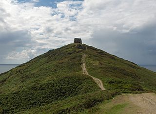
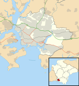
Rame Head or Ram Head is a coastal headland, southwest of the village of Rame in southeast Cornwall, United Kingdom. It is part of the larger Rame Peninsula.

Plymouth Sound, Shores and Cliffs is a Site of Special Scientific Interest (SSSI) around the Plymouth Sound, a large area of water where the River Plym and Tamar meet. It stretches across the two ceremonial counties of Devon and Cornwall and the unitary authority area of Plymouth. It contains fossils of plants and sea creatures and its cliffs show a timeline of the Middle to Early Devonian period hundreds of millions of years ago

The Bottoms is a Site of Special Scientific Interest in County Durham, England. It lies just south of the A181 road, roughly midway between the villages of Cassop and Wheatley Hill, some 10 km south-east of Durham city.

Steeple Point to Marsland Mouth is a coastal Site of Special Scientific Interest (SSSI) in Cornwall, England, UK, noted for its biological characteristics.

Porth Hellick is a tidal inlet on the south coast of St Mary’s, the largest island in the Isles of Scilly.

Blo' Norton and Thelnetham Fens are a 21.3 hectare biological Site of Special Scientific Interest (SSSI) on the Norfolk/Suffolk border. Blo' Norton Fen is in the parish of Blo' Norton in Norfolk and Thelnetham Fen is in Thelnetham parish in Suffolk. It is a Nature Conservation Review site, Grade 2, and part of the Waveney and Little Ouse Valley Fens Special Area of Conservation, Thelnetham Fen is managed by the Suffolk Wildlife Trust and Blo' Norton Fen by the Little Ouse Headwaters Project (LOHP).

Clegir Mawr is a Site of Special Scientific Interest (SSSI) in the community of Cylch-y-Garn in the north-west of the island of Anglesey, Wales. It is a stony coastal headland with an area just under 10 hectares and has been designated principally because of the occurrence of the spotted rock-rose which is a nationally rare plant and also the county flower of Anglesey.

North Devon's Biosphere Reserve is a UNESCO biosphere reserve in North Devon. It covers 55 square miles (140 km2) and is centred on Braunton Burrows, the largest sand dune system (psammosere) in England. The boundaries of the reserve follow the edges of the conjoined catchment basin of the Rivers Taw and the Torridge and stretch out to sea to include the island of Lundy. The biosphere reserve is primarily lowland farmland, and includes many protected sites including 63 Sites of Special Scientific Interest which protect habitats such as culm grassland and broadleaved woodlands. The most populous settlements in its buffer area are Barnstaple, Bideford, Northam, Ilfracombe, and Okehampton.

Salta Moss is a raised blanket mire which is a Site of Special Scientific Interest ('SSSI') located in the hamlet of Salta, in Cumbria, United Kingdom. It was determined to be of biological interest under the Wildlife and Countryside Act 1981. The site, measuring 45.6 hectares, was officially designated in August 1982.
Farnham Mires is a Site of Special Scientific Interest, or SSSI, to the east of the village of Farnham, North Yorkshire, England. It consists of a spring-fed marshy fen or mire with reeds and sedge, and drier calcareous grassland containing a diverse range of flora. It has a history of poaching and fox hunting, but since the late 19th century, the attention of botanists has been drawn to its large variety of flowering plants. It has received some consideration on this account since 1944, and from 1954 it was designated SSSI status. This site has no facilities, and is not open to the public.

Bishop Monkton Ings is a Site of Special Scientific Interest, or SSSI, situated east of Bishop Monkton village in North Yorkshire, England. It consists mostly of marshy, calcareous grassland, with some broadleaved woodland, and some fen alongside the two watercourses which run through the site. This varied wetland forms a habitat for a variety of plants, including the semi-parasitic marsh lousewort (Pedicularis palustris).

Mar Field Fen is a Site of Special Scientific Interest, or SSSI, north of Masham, North Yorkshire, England, in a rural area known as Marfield. It is situated on land containing woodland carr, fen, spring-fed marshy grassland and drier calcareous grassland, between the River Ure to the east and Marfield Wetland nature reserve to the west. As "one of the best examples of fen habitat in the Vale of York," it is a protected habitat for a variety of plants, including the common butterwort, a carnivorous plant. There is no public access to this site.

Hack Fall Wood, otherwise known as Hackfall, is a Site of Special Scientific Interest, or SSSI, of 44.8687 hectares, lying north-east of the village of Grewelthorpe, North Yorkshire, England. During the 18th century it was landscaped in the picturesque style by landowner William Aislabie, who created views by engineering streams and pools, planting trees and building follies. Turner and Gilpin painted it, and pictures of it featured on Catherine the Great's 1773 Wedgwood dinner service. Some 19th century writers called it "one of the most beautiful woods in the country."

Hatherton Flush is a Site of Special Scientific Interest (SSSI) by the River Weaver in Hatherton, near Wybunbury, Cheshire, England. It is protected for its variety of wetland plants. Species found at the site include the locally rare plants marsh helleborine, marsh lousewort and tubular water dropwort. Hatherton Flush is the largest example of this kind of flush in the county. The site was assessed as being in an "unfavourable"/"recovering" condition in 2008.

Milford Haven Waterway, is a Site of Special Scientific Interest (SSSI) on Milford Haven Waterway in Pembrokeshire, South Wales, designated since 2002. The site is protected for a wide range of reasons, including its geology, marine environment and ecosystems, and to protect a diversity of flora and fauna.