
Pedro Gutiérrez de Valdivia or Valdiva was a Spanish conquistador and the first royal governor of Chile. After serving with the Spanish army in Italy and Flanders, he was sent to South America in 1534, where he served as lieutenant under Francisco Pizarro in Peru, acting as his second in command.
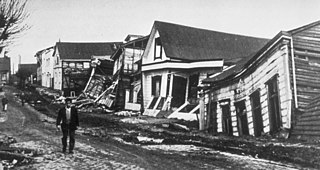
The 1960 Valdivia earthquake and tsunami or the Great Chilean earthquake on 22 May 1960 was the most powerful earthquake ever recorded. Most studies have placed it at 9.4–9.6 on the moment magnitude scale, while some studies have placed the magnitude lower than 9.4. It occurred in the afternoon, and lasted 10 minutes. The resulting tsunamis affected southern Chile, Hawaii, Japan, the Philippines, eastern New Zealand, southeast Australia, and the Aleutian Islands.

Austral University of Chile is a Chilean research university based primarily in Valdivia, with satellite campuses in Puerto Montt and Coyhaique. Founded on September 7, 1954, it is one of the eight original Chilean Traditional Universities. It operates as a nonprofit self-owned corporation under private law, and receives significant state-funding.

The Los Ríos Region is one of Chile's 16 regions, the country's first-order administrative divisions. Its capital is Valdivia. It began to operate as a region on October 2, 2007, having been created by subdividing the Los Lagos Region in southern Chile. It consists of two provinces: Valdivia and the newly created Ranco Province, which was formerly part of Valdivia Province.

Valdivia Province is one of two provinces of the southern Chilean region of Los Ríos (XIV). The provincial capital is Valdivia. Located in the province are two important rivers, the Calle-Calle / Valdivia River and the Cruces River. It is part of Northern Patagonia and its wild virgin forest embrace the Patagonian Cordillera following the river Calle Calle down to the Pacific Ocean. It is known in Patagonia by the term "Bosque Valdiviano", referring to the primitive forest of Valdivia with its native trees. These forests are present in some parts of Northern Patagonia, both in Chile and Argentina.

Valdivia is a city and commune in southern Chile, administered by the Municipality of Valdivia. The city is named after its founder, Pedro de Valdivia, and is located at the confluence of the Calle-Calle, Valdivia, and Cau-Cau Rivers, approximately 15 km (9 mi) east of the coastal towns of Corral and Niebla. Since October 2007, Valdivia has been the capital of Los Ríos Region and is also the capital of Valdivia Province. The national census of 2017 recorded the commune of Valdivia as having 166,080 inhabitants (Valdivianos), of whom 150,048 were living in the city. The main economic activities of Valdivia include tourism, wood pulp manufacturing, forestry, metallurgy, and beer production. The city is also the home of the Austral University of Chile, founded in 1954 and the Centro de Estudios Científicos.

This is a timeline of Chilean history, comprising important legal and territorial changes and political events in Chile and its predecessor states. To read about the background to these events, see History of Chile. See also the list of governors and presidents of Chile.

The Valdivia River or Río Valdivia, as it is known locally, is a major river in southern Chile. It is the continuation of the Calle-Calle River, from the point where it meets the Cau-Cau River in the city of Valdivia. The Valdivia river ends in Corral Bay, on the Pacific coast. Other tributaries are the Cruces River, the Tornagaleones River and the Futa River. Pedro de Valdivia Bridge crosses the river in downtown Valdivia.

The Cruces River is a river in south-central Chile. Río Cruces originates from hills near the Villarica volcano and flows then in south-west direction. The southern and final part of the river flows in a south-south-west direction following the eastern flank of Cordillera de Oncol. At the latitude of the city of Valdivia it is crossed by Río Cruces Bridge next to its outflow into Valdivia River.

Calle-Calle River, also called Gudalafquén in Mapuche language, is a river in Valdivia Province, southern Chile. It drains waters from the San Pedro River to the Valdivia River, which in turn flows into Corral Bay on the Pacific Ocean.
Teja island is an island in the city of Valdivia, Chile, surrounded by three rivers: Cau-Cau river to the north, Cruces river to the west and Valdivia river to the southeast. Prior to the mid-19th century, the island was known as isla Valenzuela after Francisco de Valenzuela, an encomendero that settled there in 1552. In the second half of the 19th century, the island became known for its roof tile and brick factory, hence the name isla Teja. Initially it was outside the proper city, but with the arrival of German immigrants, many of them settled there, and since 1939, the island is directly connected to downtown Valdivia through the Pedro de Valdivia bridge. A large section of the island's western riverside sank below water level due to the Great Chilean earthquake of 1960.
German Chileans are Chileans descended from German immigrants, about 30,000 of whom arrived in Chile between 1846 and 1914. Most of these were from Bavaria, Baden and the Rhineland, and also from Bohemia in present-day Czech Republic, which were traditionally Catholic. A smaller number of Lutherans immigrated to Chile following the failed revolutions of 1848.

The primary beer brewed and consumed in Chile is pale lager, though the country also has a tradition of brewing corn beer, known as chicha. Chile's beer history has a strong German influence – some of the bigger beer producers are from the country's southern lake district, a region populated by a great number of German immigrants during the 19th century. Chile also produces English ale-style craft beers while also developing its own craft beer identity.
Valdivia is one of the few cities in southern Chile with a more less continuous and well documented history from its foundation in the 16th century onwards.
From 1850 to 1875, some 30,000 German immigrants settled in the region around Valdivia, Osorno and Llanquihue in Southern Chile as part of a state-led colonization scheme. Some of these immigrants had left Europe in the aftermath of the German revolutions of 1848–49. They brought skills and assets as artisans, farmers and merchants to Chile, contributing to the nascent country's economic and industrial development.

The Dutch expedition to Valdivia was a naval expedition, commanded by Hendrik Brouwer, sent by the Dutch Republic in 1643 to establish a base of operations and a trading post on the southern coast of Chile. With Spain and the Dutch Republic at war, the Dutch wished to take over the ruins of the abandoned Spanish city of Valdivia. The expedition sacked the Spanish settlements of Carelmapu and Castro in the Chiloé Archipelago before sailing to Valdivia, having the initial support of the local natives. The Dutch arrived in Valdivia on 24 August 1643 and named the colony Brouwershaven after Brouwer, who had died several weeks earlier. The short-lived colony was abandoned on 28 October 1643. Nevertheless, the occupation caused great alarm among Spanish authorities. The Spanish resettled Valdivia and began the construction of an extensive network of fortifications in 1645 to prevent a similar intrusion. Although contemporaries considered the possibility of a new incursion, the expedition was the last one undertaken by the Dutch on the west coast of the Americas.
Las Ánimas, is an industrial and residential neighborhood located on the northern side of Valdivia
Mulpún is a coal mine and locality in Los Ríos Region, Chile. Mulpún lies in the commune of Máfil a few kilometers to the west of the Chile Route 5 and north of the Calle-Calle and San Pedro River.

