
The Salt River is a river in Gila and Maricopa counties in Arizona, United States, that is the largest tributary of the Gila River. The river is about 200 miles (320 km) long. Its drainage basin covers about 13,700 square miles (35,000 km2). The longest of the Salt River's many tributaries is the 195-mile (314 km) Verde River. The Salt's headwaters tributaries, the Black River and East Fork, increase the river's total length to about 300 miles (480 km). The name Salt River comes from the river's course over large salt deposits shortly after the merging of the White and Black Rivers.

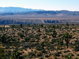
Northern Arizona is an unofficial, colloquially defined region of the U.S. state of Arizona. Generally consisting of Apache, Coconino, Mohave, Navajo, and Yavapai counties, the region is geographically dominated by the Colorado Plateau, the southern border of which in Arizona is called the Mogollon Rim.

Noonday Creek is a 20.2-mile-long (32.5 km) stream in Cobb and Cherokee counties in the U.S. state of Georgia. The stream begins near Kennesaw Mountain and ends at Lake Allatoona.
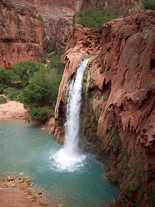
Havasu Falls is a waterfall of Havasu Creek, located in the Grand Canyon, Arizona, United States. It is within Havasupai tribal lands.

The Addicks Reservoir and Addicks Dam in conjunction with the Barker Reservoir prevent downstream flooding of Buffalo Bayou in the city of Houston, Texas. Both reservoirs were authorized under the Rivers and Harbors Act of June 20, 1938, which was modified by the Flood Control Acts of 1938, 1954, and 1965. The US Army Corps of Engineers (USACE) completed construction of Addicks Dam and the outlet facility in 1948.

North/Northwest Phoenix is a region in the city of Phoenix, Arizona. While the area with this name has no official separate status, it usually refers to the Urban Villages of Paradise Valley, North Mountain, Deer Valley, Desert View, and North Gateway.
The Beaver Dam Wash is a seasonal stream near the southwestern Utah-Nevada border in the United States. At its southern end in northern Arizona, near the point where it empties into the Virgin River, the stream flows throughout the year. Part of the wash is in the Beaver Dam Wash National Conservation Area, managed by the Bureau of Land Management. The wash was so named on account of beaver dams which once were built on its course.
Cedar Creek is a 53-kilometre-long (33 mi) stream in southeastern Wisconsin in the United States. The Cedar Creek watershed is a 330 km2 (127 mi2) sub-basin of the larger Milwaukee River watershed.
Meadow Pond Dam was an earthen dam in Alton, New Hampshire, in the United States, that collapsed in 1996, causing a fatal flood.
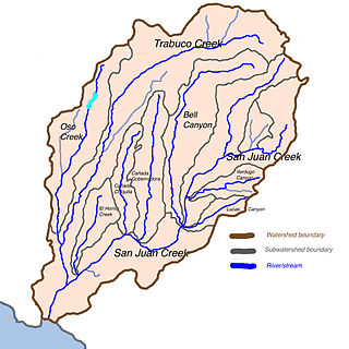
Trampas Canyon is a short tributary of San Juan Creek in southern Orange County the U.S. state of California. It rises in forks on steep slopes of the southern Santa Ana Mountains, and flows north to where it is dammed by Trampas Canyon Dam. Trampas Canyon 1795-006 Dam (33.498359°N 117.587548°W) forms a small lake that branches into four forks running east–west. Exiting the dam, the creek flows north and turns slightly to the west, where it joins San Juan Creek on the left bank, near the confluence of Cañada Gobernadora. Trampas Canyon Creek is ephemeral and only flows during storm events or while Trampas Canyon Dam is releasing, and is not a primary tributary of San Juan Creek.

Barker Reservoir is a flood control structure in Houston, Texas which prevents downstream flooding of Buffalo Bayou, the city's principal river. The reservoir operates in conjunction with Addicks Reservoir to the northeast, which impounds Mayde and Bear Creeks, two tributaries of the Buffalo. Both reservoirs were authorized under the Rivers and Harbors Act of June 20, 1938, which were modified by the Flood Control Acts of August 11, 1938; September 3, 1954; and October 27, 1965.

Havasu Creek is a stream in the U.S. state of Arizona. It is a tributary to the Colorado River, which it joins in the Grand Canyon. It primarily runs through the Havasupai Indian Reservation. It is sometimes called Cataract Creek, and should not be confused with Cataract Canyon, Utah.

Temescal Creek is an approximately 29-mile-long (47 km) watercourse in Riverside County, in the U.S. state of California. Flowing primarily in a northwestern direction, it connects Lake Elsinore with the Santa Ana River. It drains the eastern slopes of the Santa Ana Mountains on its left and on its right the western slopes of the Temescal Mountains along its length. With a drainage basin of about 1,000 square miles (2,600 km2), it is the largest tributary of the Santa Ana River, hydrologically connecting the 720-square-mile (1,900 km2) San Jacinto River and Lake Elsinore watersheds to the rest of the Santa Ana watershed. However, flowing through an arid rain shadow zone of the Santa Ana Mountains, and with diversion of ground water for human use, the creek today is ephemeral for most of its length, except for runoff from housing developments and agricultural return flows.

The Gila Bend Mountains are a 35-mile (56 km) long mountain range of the north-central Sonoran Desert southwest of Phoenix, Arizona and in southwest Maricopa County.
The Belmont Mountains are a 25 mi (40 km) long, arid, low elevation mountain range about 50 mi west of Phoenix, Arizona in the northern Sonoran Desert, north of the Gila River. The range is in the south of a region of two parallel washes; the Bouse Wash flows northwest to the Colorado River, and the Centennial Wash flows southeast to meet the Gila River.

Murphey Candler Park is a 135-acre multi-use park located in Brookhaven, Georgia, United States. The park is owned and operated by the City of Brookhaven. Park amenities include multi-use fields, tennis courts, a swimming pool, a playground, picnic areas, a lake, and trails. Youth sports are offered through baseball, softball, and football programs that operate through the park. The lake at Murphey Candler Park offers fishing, and it is home to largemouth bass, bluegill, redear sunfish, and channel catfish. The lake is also home to Canada Geese, Mallards, other ducks and beavers.

Deer Valley is located in the city of Phoenix, Arizona, United States. As of 2010, the population was 165,656, 25% of whom were under 18 years of age. The origin of the name is unclear; it first appeared on a 1921 United States General Land Office map of the area describing the valley created by Skunk Creek.
The Cave Creek Dam is a multiple-arch concrete dam located near Cave Creek, Arizona that was built in 1923 by John Samuel Eastwood and was the primary dam preventing flooding in North Phoenix from 1923 to 1979, when it was replaced by the earthen Cave Buttes Dam further down the Cave Creek Wash.

Lake Amanda is a private artificial lake in Tyler County, Texas, near the town of Colmesneil, that along with its sister Frog Pond, were developed in the 1950s and 1960s by James Haralson from his family's old homestead. The lake was named after Haralson's daughter. The lots surrounding the lake were originally designed as fish camps where families could come to camp, fish, and enjoy the outdoors. Today some people call the lake home full-time, others are there enjoying their retirement, and others just visit as a weekend get-away.
 The Cave Buttes Dam, an earthen dam located near Cave Creek, Arizona.
 Road leading to the Cave Buttes Dam

