
The Motagua Valley thornscrub ecoregion is located in the Motagua valley in eastern Guatemala. Surrounded by mountains and receiving relatively little precipitation, the valley is one of the driest in Central America and is characterized by thorn scrub vegetation. It covers an area of 2330 km2 and belongs to the deserts and xeric shrublands biome, as defined by the World Wildlife Fund.
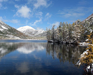
The Okhotsk-Manchurian taiga ecoregion is an area of coniferous forests in the Russian Far East, covering the Amur River delta, the west coast of the Okhotsk Sea, and the rugged extension of the northern Sikhote-Alin Mountains that run southwest-to-northeast through the Primorsky and Khabarovsk regions. It is the southernmost taiga forest in Eurasia. The ecoregion is distinguished from surrounding ecoregions by the slightly warmer climate due to the maritime influence and the shield of the mountains to the west, and by the mixing of flora and fauna species from Okhotsk-Kamchatka communities to the north and Manchurian species from the south. The forest at lower altitudes is "light taiga", and "dark taiga" at higher altitudes.

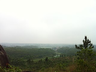
The Hainan Island monsoon rain forests ecoregion covers mountainous interior of Hainan Island in China. The tropical forests receive over 1,000 mm/year of rain, heavily concentrated in the summer rainy season. The island has high levels of biodiversity, with over 4,200 plant species, 630 of which are endemic to the island. The region is under ecological pressure from deforestation for agriculture and timber extraction.
The South China-Vietnam subtropical evergreen forests ecoregion covers the mountainous coastal region of southeastern China and northeastern Vietnam. The ecoregional also covers the coastal plain along the South China Sea and Hainan Island. The area has significant biodiversity and ecological importance, with high levels of both endemic and threatened species. Rapid urban expansion is reducing biologically-rich forests and wetlands. Ecologically, the subtropical forests are at the northeastern extent of the Indomalayan realm.

The Kopet Dag woodlands and forest steppe ecoregion coincides with the Kopet Dag mountains, straddling the southern border of Turkmenistan and the northeastern border of Iran. The region is one of high biodiversity, as it includes a full range of altitude zones, and variety of habitats included juniper-wooded slopes, montane grasslands, and tugay.

The Northern Annamites rain forests ecoregion covers the rugged and relatively unexplored northern Annamite Mountains of central Laos and Vietnam. There are high numbers of endemic plant species, and the relative remoteness and isolation of the area supports many rare and endangered animals. Rainfall is somewhat less than the lowland rainforest of the lower elevations in Vietnam, and the temperatures slightly cooler due to the higher elevation.

The Southern Vietnam lowland dry forests ecoregion covers the low, relatively arid coastal strip of southern Vietnam on the South China Sea. The region is in the rain shadow of the Southern Annamite Range, which blocks humid air from the west. Although approximately half of the ecoregion is forested to some degree, most has at some point been cleared for agriculture or degraded by extraction of hardwoods. There are few protected areas.
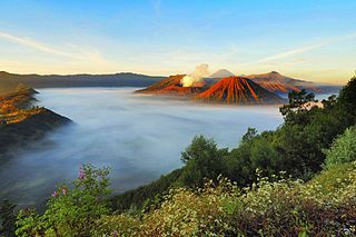
The Eastern Java–Bali montane rain forests ecoregion covers the higher altitude mountain rainforests on the eastern side of the island of Java, and most of the center of the island of Bali in Indonesia. The region has a number of active volcanoes, but is under pressure from growing human populations pushing into higher elevations and more marginal land. With elevations rising from sea level to 3,426 metres (11,240 ft), and precipitation varying between rainforest and drier forest levels, the area has many different forest types – evergreen, deciduous and semi-alpine.
The Eastern Java-Bali rain forests ecoregion covers the lowland areas of the eastern half of the island of Java, and the island of Bali, in Indonesia. This ecoregion is distinct from the Eastern Java-Bali montane rain forests, which exists at higher elevations where mountain forest habitat dominates. Very little of the natural lowland rainforest remains in its pre-human settlement state.

The Mindoro rain forests ecoregion covers the island of Mindoro, which lies between the island of Luzon and the Palawan Archipelago in the Philippines. The island has been subject to heavy commercial logging, with the only original forests remaining on the high ridge of the central mountain range. Logging has been reduced long enough on the east side of the mountains to support a regrown forest and a number of endemic species.
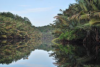
The Sumatran peat swamp forests ecoregion covers the low-lying peat swamp forests along the northeast coast of the island of Sumatra in Indonesia. As is typical for peat swamp forests, this ecoregion lies between a thin strip of saltwater-affected mangroves on the coast, and freshwater swamps and lowland rainforest forest on better drained soils further inland. Because the peat soil has relatively low nutrient levels, this ecoregion has been less used for agriculture, but burning and clearance has degraded half of the forest.

The Palawan rain forests ecoregion covers the Palawan Island Archipelago, centered on Palawan Island, the sixth largest island in the Philippines. The islands act as an ecological bridge between Borneo and the main islands of the Philippines, even though there were channels between the islands through the last ice age when sea levels were low. Biodiversity is high in the islands, with many endemic species, and with many genera shared with Borneo to the south. Pressure from logging is a concern for the forests of this region.

The Panamanian dry forests ecoregion covers low-lying dry forests around the coast of the Gulf of Panama on the Pacific Ocean side of Panama. It is one of the most heavily degraded ecoregions in Central America, having been heavily converted to agriculture. However, it is also important for its high biodiversity, high rates of endemic species, and its importance as a biological corridor between the moist forests inland and the mangroves on the coast.

The Sulaiman Range alpine meadows ecoregion covers a series of higher altitude mountain ranges along the crest of the Sulaiman Mountains, a southerly extension of the Hindu Kush Mountains along the Afghanistan-Pakistan border. The area is relatively undeveloped, with about a third of the terrain either forested or in 'alpine steppe' shrub or herbaceous cover.

The Petenes mangroves ecoregion covers mangrove habitat along the Gulf of Mexico coast of southern Mexico, where Campeche state and Yucatan state meet, centering on the Celestun Lagoon inland from the barrier-island town of Celestún. Because the region has relatively little rainfall and no rivers feeding the lagoons, the freshwater to support the mangrove ecosystem springs from underground aquifers. The area is important for migratory birds, and as a nesting area for sea turtles. The area around the Celestun Lagoon is protected by the Ría Celestún Biosphere Reserve, a UNESCO Biosphere Reserve, and Los Petenes Biosphere Reserve in Campeche.

The Southern Dry Pacific Coast mangroves ecoregion covers a series of mangrove forests along the Pacific Ocean coast of Nicaragua and Costa Rica, from the southern margin of the Gulf of Fonseca to the Gulf of Nicoya near the border with Panama. Because the area is drier than the mangroves further south, evapotranspiration leaves some areas with higher salinity and even salt pans in the internal areas.

The Christmas and Cocos Islands tropical forests ecoregion covers forested areas of Christmas Island and North Keeling Island, two small seamount islands south of the Indonesian island of Java. The forests of these two islands share tree species of the Indo-Pacific and Melanesian types on nearby islands, the forests of Christmas Island and North Keeling Island are unique in how they reflect the effects of large populations of terrestrial red crabs. Because of the remoteness of the islands, there are many endemic species.

The Trinidad and Tobago moist forests ecoregion covers most of Trinidad Island and Tobago Island near the coast of South America where the southeastern Caribbean Sea meets the Atlantic Ocean. Small portions of the islands around river estuaries and coastal lowlands are mangroves or dry forests. Species diversity is very high, in particular for plants and birds. Tobago, being much smaller, has fewer species.

The Windward Islands xeric scrub ecoregion covers the relatively small areas of the Windward Islands that receive low levels of precipitation. The dry areas of these islands are the low coastal areas that receive less precipitation. Because the dry scrub land is generally flat, near the coast, and not as obviously in need of conservation as the upland forests of the interior, they are more vulnerable to human settlement and development for agriculture.
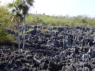
The Cayman Islands xeric scrub ecoregion covers a portion of the Cayman Islands in the Caribbean Sea. The dry ('xeric') parts of the island are surrounded by mangroves, dry forest, or developed areas. Grand Cayman Island has been heavily cleared or degraded for human development; while the less populated islands have more intact shrub and wooded habitat.

