

The Botanic Park and Salina Reserve Important Bird Area comprises two separate sites on Grand Cayman, one of the Cayman Islands, a British Overseas Territory in the Caribbean Sea.
The Botanic Park and Salina Reserve Important Bird Area comprises two separate sites on Grand Cayman, one of the Cayman Islands, a British Overseas Territory in the Caribbean Sea.
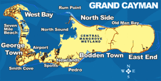
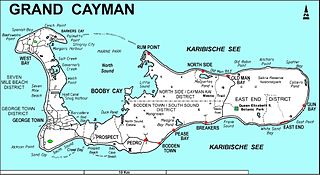
Both sites lie in the East End district of Grand Cayman. The 50 ha Queen Elizabeth II Botanic Park in the centre of the island contains fragments of native dry forest and shrubland, with a lake and Conocarpus erectus dominated wetlands. The Botanic Park site is also largely surrounded by the Frank Sound Forest IBA. [1]
Salina Reserve, lying inland from the north-east coast, is a 125 ha freshwater herbaceous wetland. It is surrounded by a fringe of Typha sedgeland and Conocarpus shrubland, with 135 ha of Swietenia mahagoni dominated dry forest on the northern boundary. The reserve lies over the northern part of the largest freshwater lens in the eastern part of the island and is not easily accessible. [1]
The two sites, with a combined area of 276 ha, have been identified by BirdLife International as an Important Bird Area (IBA) because it supports populations of West Indian whistling ducks (with 10 breeding pairs), white-crowned pigeons, Cuban amazons (10 pairs), Caribbean elaenias, thick-billed and Yucatan vireos, and vitelline warblers. [1]

Lake Victoria is a 139-hectare (340-acre) shallow saline lake on the Bellarine Peninsula, Victoria in Australia, close to the township of Point Lonsdale and part of the Lonsdale Lakes Nature Reserve administered by Parks Victoria.

The Bluff is the highest part of the Cayman Islands, a British Overseas Territory in the Caribbean Sea. It stands at the eastern end of the island of Cayman Brac and has a maximum elevation of 43 m (141 ft).

The Hunter Estuary Wetlands comprise a group of associated wetlands at and near the mouth of the Hunter River in the city of Newcastle, New South Wales, Australia. Some 30 km2 of the wetlands has been recognised as being of international importance by designation under the Ramsar Convention. It was listed on 21 February 1984 as Ramsar site 287. A larger area of the wetlands has been identified by BirdLife International as an Important Bird Area (IBA). The wetlands are recognised as the most important area in New South Wales for waders, or shorebirds.

Queen Elizabeth II Botanic Park is a non-profit outdoor garden and wildlife facility located in the North Side District of Grand Cayman Island in the British West Indies. The park is owned jointly by the Cayman Islands Government and the National Trust for the Cayman Islands, a group dedicated to preserving natural environments and places of historic significance in the Cayman Islands. Opened in 1994 with only the Woodland Trail completed, the park now also contains the Floral Colour Garden, a Cayman Heritage Garden, a lake, an orchid boardwalk exhibit, and a Blue Iguana Habitat. Also inside the park is a gift shop and a visitor's interpretive center, the starting point from which visitors can enter the Woodland Trail and other garden grounds.

The Natimuk-Douglas Wetlands comprise a chain of freshwater, brackish and saline wetlands in the semi-arid Wimmera region of western Victoria. Australia. They are important for waterbirds.

The Owingup Swamp and Boat Harbour Wetlands Important Bird Area is a 442 ha site comprising Owingup Swamp, and ten other, smaller, wetlands nearby, in the Great Southern region of south-western Australia. It lies about 25 km south-south-west of Denmark, Western Australia, near the track to the coast at Boat Harbour cove. The site has been identified by BirdLife International as an Important Bird Area (IBA) because it is supports small numbers of the endangered Australasian bittern.

The Tarrabool Lake – Eva Downs Swamp System is an ephemeral wetland complex lying on the west of the Barkly Tableland region in the Northern Territory of Australia. It is listed on the DIWA wetland directory.

The Yambuk Important Bird Area comprises a 10 km2 tract of coastal land fronting Bass Strait in south-western Victoria, south-eastern Australia. It lies some 20 km west of the town of Port Fairy and encompasses the lower reaches of the Eumeralla River and Lake Yambuk.

Logan Lagoon is a 2172 ha wetland Conservation Area on Flinders Island, the largest of the Furneaux Group at the eastern end of Bass Strait, which is part of the Australian state of Tasmania.

The Sungai Clere Important Bird Area, also known as the Sungai Clere Protected Wildlife Area, and in Indonesian as Hutan Metiboat, is a tract of low-lying forest and grassland in East Timor, a country occupying the eastern end of the island of Timor in the Lesser Sunda Islands of Wallacea.

Booby Pond Nature Reserve is a protected wetland on Little Cayman, one of the Cayman Islands, a British Overseas Territory in the Caribbean Sea.
The Central Manrove Wetland is a large area of mangrove dominated wetland on Grand Cayman, one of the Cayman Islands, a British Overseas Territory in the Caribbean Sea. It is one of the territory's Important Bird Areas (IBAs).
The Crown Wetlands lie on Little Cayman, one of the Cayman Islands, a British Overseas Territory in the Caribbean Sea. Collectively they form one of the territory's Important Bird Areas (IBAs).
The Eastern Dry Forest lies at the eastern end of Grand Cayman, one of the Cayman Islands, a British Overseas Territory in the Caribbean Sea. It is one of the territory's Important Bird Areas (IBAs).
Frank Sound Forest lies near the southern coast of the East End district of Grand Cayman, one of the Cayman Islands, a British Overseas Territory in the Caribbean Sea. It is one of the territory's Important Bird Areas (IBAs).
Franklin's Forest lies near the centre of the East End distinct of Grand Cayman, one of the Cayman Islands, a British Overseas Territory in the Caribbean Sea. It is one of the territory's Important Bird Areas (IBAs).
Mastic Reserve lies at the eastern end of the North Side of Grand Cayman, one of the Cayman Islands, a British Overseas Territory in the Caribbean Sea. It, with the associated Mastic Trail, is managed by the National Trust for the Cayman Islands and is one of the territory's Important Bird Areas (IBAs). It is named after the yellow mastic and black mastic trees which occur in the reserve.

The Quill/Boven National Park comprises two separated sections of protected land at opposite ends of the island of Sint Eustatius in the Dutch Caribbean. Both parts of the park have been identified by BirdLife International as Important Bird Areas (IBAs) because they support populations of several threatened or restricted-range bird species.

The Enriquillo wetlands are a flooded grasslands and savannas ecoregion on the island of Hispaniola. They cover about 628 km2 (242 sq mi) around several low-lying lakes in southwestern Hispaniola in both the Dominican Republic and Haiti.

The Cayman Islands dry forests ecoregion covers about half of the Cayman Islands in the Caribbean Sea. The other half of the low-lying islands are mangroves. The dry forests of Grand Cayman have been heavily cleared or degraded for human development; the less populated islands have more intact wooded habitat.
Coordinates: 19°19′00″N81°10′00″W / 19.31667°N 81.16667°W
| | This Cayman Islands location article is a stub. You can help Wikipedia by expanding it. |