

Frank Sound Forest lies near the southern coast of the East End district of Grand Cayman, one of the Cayman Islands, a British Overseas Territory in the Caribbean Sea. It is one of the territory's Important Bird Areas (IBAs).
Frank Sound Forest lies near the southern coast of the East End district of Grand Cayman, one of the Cayman Islands, a British Overseas Territory in the Caribbean Sea. It is one of the territory's Important Bird Areas (IBAs).
Frank Sound Forest is a 223 ha tract of native tropical dry forest surrounding Queen Elizabeth II Botanic Park. it is privately owned, unprotected and is subject to fragmentation and clearance for agricultural and urban development. [1]
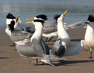
The IBA was identified as such by BirdLife International because it supports populations of Cuban amazons, Caribbean elaenias, thick-billed vireos, Yucatan vireos and vitelline warblers. [1]
The Ogasan Nature Reserve is a national park located in North Korea. It is situated around Mount Oga, which straddles the borders of Hwap'yŏng county in Chagang Province and Kimhyŏngjik county in Ryanggang.

The Bluff is the highest part of the Cayman Islands, a British Overseas Territory in the Caribbean Sea. It stands at the eastern end of the island of Cayman Brac and has a maximum elevation of 43 m (141 ft).
Seagull Island is a 58 ha linear sand island, about 2.5 km long, lying 4 km off Cape Van Diemen on the north-west coast of Melville Island, in the Tiwi Island group, in the Northern Territory of Australia. It is an important breeding site for seabirds.

The Tilomar Important Bird Area, also known as Tilomar Forest, is a tract of mainly forested land in East Timor, a country occupying the eastern end of the island of Timor in the Lesser Sunda Islands of Wallacea.

Booby Pond Nature Reserve is a protected wetland on Little Cayman, one of the Cayman Islands, a British Overseas Territory in the Caribbean Sea.
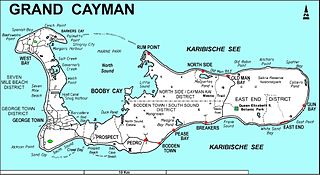
The Botanic Park and Salina Reserve Important Bird Area comprises two separate sites on Grand Cayman, one of the Cayman Islands, a British Overseas Territory in the Caribbean Sea.
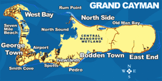
The Central Manrove Wetland is a large area of mangrove dominated wetland on Grand Cayman, one of the Cayman Islands, a British Overseas Territory in the Caribbean Sea. It is one of the territory's Important Bird Areas (IBAs).
The Crown Wetlands lie on Little Cayman, one of the Cayman Islands, a British Overseas Territory in the Caribbean Sea. Collectively they form one of the territory's Important Bird Areas (IBAs).
The Eastern Dry Forest lies at the eastern end of Grand Cayman, one of the Cayman Islands, a British Overseas Territory in the Caribbean Sea. It is one of the territory's Important Bird Areas (IBAs).
Franklin's Forest lies near the centre of the East End distinct of Grand Cayman, one of the Cayman Islands, a British Overseas Territory in the Caribbean Sea. It is one of the territory's Important Bird Areas (IBAs).
Mastic Reserve lies at the eastern end of the North Side of Grand Cayman, one of the Cayman Islands, a British Overseas Territory in the Caribbean Sea. It, with the associated Mastic Trail, is managed by the National Trust for the Cayman Islands and is one of the territory's Important Bird Areas (IBAs). It is named after the yellow mastic and black mastic trees which occur in the reserve.
Sparrowhawk Hill lies in the centre of Little Cayman, one of the Cayman Islands, a British Overseas Territory in the Caribbean Sea. It is one of the territory's Important Bird Areas (IBAs).

Road Salt Pond, also known as Road Bay Pond or simply Road Pond, is a wetland in Anguilla, a British Overseas Territory in the Caribbean Sea. It is one of the territory's Important Bird Areas (IBAs).
Cauls Pond is a wetland in Anguilla, a British Overseas Territory in the Caribbean Sea. It is one of the territory's Important Bird Areas (IBAs).
West End Pond is a wetland in Anguilla, a British Overseas Territory in the Caribbean Sea. It is one of the territory's Important Bird Areas (IBAs).
Forest Bay Pond is a small wetland in Anguilla, a British Overseas Territory in the Caribbean Sea. It forms one of the territory's Important Bird Areas (IBAs).

The Northern Forested Ghauts constitute a tract of land on the island of Montserrat, a British Overseas Territory in the Leeward Islands of the Caribbean Sea. It forms one of the territory's Important Bird Areas (IBAs).
Centre Hills is a forest reserve on the island of Montserrat, a British Overseas Territory in the Leeward Islands of the Caribbean Sea. It forms one of the territory's Important Bird Areas (IBAs), which encompasses the forest reserve as well as additional habitat for the Montserrat oriole, the territory's endemic, and critically endangered, national bird.
South Soufriere Hills is a 35 ha patch of forest on the island of Montserrat, a British Overseas Territory in the Leeward Islands of the Caribbean Sea. It forms one of the territory's Important Bird Areas (IBAs).

The Wades Green and Teren Hill Important Bird Area is a 226 ha tract of land on the island of North Caicos in the Turks and Caicos Islands, a British Overseas Territory in the Lucayan Archipelago of the western Atlantic Ocean. It forms one of the territory's Important Bird Areas (IBAs).
Coordinates: 19°20′00″N81°09′00″W / 19.33333°N 81.15000°W
| | This Cayman Islands location article is a stub. You can help Wikipedia by expanding it. |