

Cecilie Mauritzen (born 1961 in Oslo) [1] is a Norwegian physical oceanographer who studies connections between ocean currents and climate change. [1]
Cecilie Mauritzen (born 1961 in Oslo) [1] is a Norwegian physical oceanographer who studies connections between ocean currents and climate change. [1]
Mauritzen works as a researcher in the Norwegian Meteorological Institute. [2] She graduated from the University of Bergen in 1987, and earned a PhD in 1994 from the Massachusetts Institute of Technology. [1] [3] After working for NASA at the Goddard Space Flight Center and for the Woods Hole Oceanographic Institution, she joined the Norwegian Meteorological Institute in 2002, [4] and eventually became director of the climate division there. [3] She was also the director of the Centre for International Climate and Environmental Research (CICERO) from 2012 to 2013. [3] [5] She returned to the Norwegian Meteorological Institute after working as vice president for Research at DNV GL, and as a head of climate research at the Norwegian Institute for Water Research (NIVA). [4]
Her early contributions to oceanography are described in the textbook "Ocean Circulation in Three Dimensions [6] " by Barry Klinger ("What Wrong Looks Like from the Inside"):
The Nordic Seas provide another example of conventional wisdom being replaced by a new idea. On global scales, warm water becomes colder and denser as it flows to polar regions, where the densest water sinks as part of the process of deep water formation. Therefore it was easy to accept a conceptual model of deep water formation in the Nordic Seas in which surface water enters from the Atlantic and cools as it flows into central regions of the basin, and part of the resulting water mass returns to the Atlantic in the dense overflows at the Greenland-Iceland-Scotland Ridge. Some of the densest surface water in the basin occurs in that area, which undergoes intense winter heat loss to the atmosphere and dramatic convection. Numerical models of convection [7] show how an isolated region of cooling creates a subsurface tower of dense water which carries water downward when it slumps due to eddy generation.This model of Nordic Seas circulation was overturned by Norwegian oceanographer Cecilie Mauritzen in her PhD dissertation [8] [9] . She showed that the water took a longer route from the inflow to the outflow, with most of the cooling occurring in boundary currents around the periphery of the Nordic Seas and in the Arctic Ocean. Much of the large heat loss in the central basin was merely part of the seasonal cycle of temperature change of a thick layer of water, with relatively small volume transports exchanged with incoming or outgoing water. Later, numerical experiments such as [10] showed that a fluid exchange between cooling basin and the rest of the ocean mostly occurred around the basin boundaries, with cold but relatively quiescent water in the middle "
In 2004, Mauritzen was included in the lead author team to write IPCC Fourth Assessment Report (2007), [11] and since then she has focussed her work primarily on climate change. Nevertheless, in 2007–2009, during the International Polar Year, she led one of the Norwegian flagship projects: IAOOS Norway: Closing the loop. [12]
She rejoined IPCC for the Fifth Assessment Report (2014), as a lead author for the ocean chapter. [13]
Mauritzen's wide range of interests can best be described by the variety of her portfolio of research projects: only post 2020 she has led a project on machine learning on turbulence (Machine Ocean), a project on forecasting water quality (MARTINI) and an EU Horizon project on Integrated Assessment Modelling ( WorldTrans - Transparent Assessments for Real People).
Mauritzen lives in Oslo and has two grown sons.
Mauritzen is a member of the Norwegian Academy of Science and Letters and of the Norwegian Scientific Academy for Polar Research. In 2011 she received the "Fram Award for Polar Research", by the Committee for the Preservation of the Polar Ship Fram.

North Atlantic Deep Water (NADW) is a deep water mass formed in the North Atlantic Ocean. Thermohaline circulation of the world's oceans involves the flow of warm surface waters from the southern hemisphere into the North Atlantic. Water flowing northward becomes modified through evaporation and mixing with other water masses, leading to increased salinity. When this water reaches the North Atlantic it cools and sinks through convection, due to its decreased temperature and increased salinity resulting in increased density. NADW is the outflow of this thick deep layer, which can be detected by its high salinity, high oxygen content, nutrient minima, high 14C/12C, and chlorofluorocarbons (CFCs).

An ocean current is a continuous, directed movement of seawater generated by a number of forces acting upon the water, including wind, the Coriolis effect, breaking waves, cabbeling, and temperature and salinity differences. Depth contours, shoreline configurations, and interactions with other currents influence a current's direction and strength. Ocean currents are primarily horizontal water movements.

Physical oceanography is the study of physical conditions and physical processes within the ocean, especially the motions and physical properties of ocean waters.

Thermohaline circulation (THC) is a part of the large-scale ocean circulation that is driven by global density gradients created by surface heat and freshwater fluxes. The adjective thermohaline derives from thermo- referring to temperature and -haline referring to salt content, factors which together determine the density of sea water. Wind-driven surface currents travel polewards from the equatorial Atlantic Ocean, cooling en route, and eventually sinking at high latitudes. This dense water then flows into the ocean basins. While the bulk of it upwells in the Southern Ocean, the oldest waters upwell in the North Pacific. Extensive mixing therefore takes place between the ocean basins, reducing differences between them and making the Earth's oceans a global system. The water in these circuits transport both energy and mass around the globe. As such, the state of the circulation has a large impact on the climate of the Earth.

The East Greenland Current (EGC) is a cold, low-salinity current that extends from Fram Strait (~80N) to Cape Farewell (~60N). The current is located off the eastern coast of Greenland along the Greenland continental margin. The current cuts through the Nordic Seas and through the Denmark Strait. The current is of major importance because it directly connects the Arctic to the Northern Atlantic, it is a major contributor to sea ice export out of the Arctic, and it is a major freshwater sink for the Arctic.
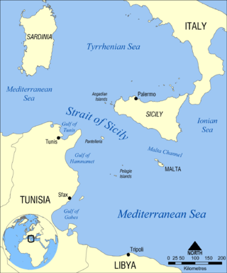
The Strait of Sicily is the strait between Sicily and Tunisia. The strait is about 145 kilometres (90 mi) wide and divides the Tyrrhenian Sea and the western Mediterranean Sea, from the eastern Mediterranean Sea. The maximum depth is 316 meters (1,037 ft). The island of Pantelleria lies in the middle of the strait.

The Greenland Sea is a body of water that borders Greenland to the west, the Svalbard archipelago to the east, Fram Strait and the Arctic Ocean to the north, and the Norwegian Sea and Iceland to the south. The Greenland Sea is often defined as part of the Arctic Ocean, sometimes as part of the Atlantic Ocean. However, definitions of the Arctic Ocean and its seas tend to be imprecise or arbitrary. In general usage the term "Arctic Ocean" would exclude the Greenland Sea. In oceanographic studies the Greenland Sea is considered part of the Nordic Seas, along with the Norwegian Sea. The Nordic Seas are the main connection between the Arctic and Atlantic oceans and, as such, could be of great significance in a possible shutdown of thermohaline circulation. In oceanography the Arctic Ocean and Nordic Seas are often referred to collectively as the "Arctic Mediterranean Sea", a marginal sea of the Atlantic.

The Atlantic meridional overturning circulation (AMOC) is part of a global thermohaline circulation in the oceans and is the zonally integrated component of surface and deep currents in the Atlantic Ocean. It is characterized by a northward flow of warm, salty water in the upper layers of the Atlantic, and a southward flow of colder, deep waters. These "limbs" are linked by regions of overturning in the Nordic and Labrador Seas and the Southern Ocean, although the extent of overturning in the Labrador Sea is disputed. The AMOC is an important component of the Earth's climate system, and is a result of both atmospheric and thermohaline drivers.

The Weddell Gyre is one of the two gyres that exist within the Southern Ocean. The gyre is formed by interactions between the Antarctic Circumpolar Current (ACC) and the Antarctic Continental Shelf. The gyre is located in the Weddell Sea, and rotates clockwise. South of the ACC and spreading northeast from the Antarctic Peninsula, the gyre is an extended large cyclone. Where the northeastern end ends at 30°E, which is marked by the southward turn of the ACC, the northern part of the gyre spreads over the Southern Scotia Sea and goes northward to the South Sandwich Arc. Axis of the gyre is over the southern flanks of the South Scotia, America-Antarctic, and Southwest Indian Ridges. In the southern part of the gyre, the westward return flow is about 66 sverdrup (Sv), while in the northern rim current, there is an eastward flow of 61 Sv.
Lynne Talley is a physical oceanographer at Scripps Institution of Oceanography known for her research into the large-scale circulation of water masses in the global ocean.
The Gulf Stream, together with its northern extension the North Atlantic Drift, is a warm and swift Atlantic ocean current that originates in the Gulf of Mexico and flows through the Straits of Florida and up the eastern coastline of the United States, then veers east near 36°N latitude and moves toward Northwest Europe as the North Atlantic Current. The process of western intensification causes the Gulf Stream to be a northward-accelerating current off the east coast of North America. Around 40°0′N30°0′W, it splits in two, with the northern stream, the North Atlantic Drift, crossing to Northern Europe and the southern stream, the Canary Current, recirculating off West Africa.
The Great Salinity Anomaly (GSA) originally referred to an event in the late 1960s to early 1970s where a large influx of freshwater from the Arctic Ocean led to a salinity anomaly in the northern North Atlantic Ocean, which affected the Atlantic meridional overturning circulation. Since then, the term "Great Salinity Anomaly" has been applied to successive occurrences of the same phenomenon, including the Great Salinity Anomaly of the 1980s and the Great Salinity Anomaly of the 1990s. The Great Salinity Anomalies were advective events, propagating to different sea basins and areas of the North Atlantic, and is on the decadal-scale for the anomalies in the 1970s, 1980s, and 1990s.
The East Iceland Current (EIC) is a cold water ocean current that forms east of Greenland at 72°N, 11°W as a branch of the East Greenland Current that merges with the Irminger Current flowing southward until it meets the northeast part of Iceland. It quickly rotates in a counterclockwise direction and flows eastward along the Iceland-Faeroe Ridge before turning north and flowing into the Norwegian Sea. The EIC flows at an average rate of 6 centimeters per second, with a maximum velocity of 10 centimeters per second occurring as the current turns eastward.
The Denmark Strait cataract is an undersea waterfall located in the Denmark Strait between Greenland and Iceland. It is the tallest undersea waterfall, with water falling over 3.5 km (2.2 mi); this descent is over three times the height of Angel Falls, the world's tallest uninterrupted waterfall over land. The cataract transports around 3.2 million m3 (110 million cu ft) of water per second, greatly eclipsing the discharge of the Amazon River into the Atlantic Ocean and the flow rate of the former Guaíra Falls. The descending column of water is approximately 200 m (660 ft) wide and 200 m (660 ft) thick and descends over a length of around 1,000 km (620 mi). It is formed by the density difference of the water masses either side of the Denmark Strait; the southward-flowing water originating from the Nordic Seas is colder and consequently more dense than the Irminger Sea to the south of the strait. At the Greenland–Iceland Rise – an elevated ridge forming the cataract's apex – the colder water cascades along the seafloor to a depth of around 3,000 m (10,000 ft). Due to the Coriolis effect, the downward flow of water is deflected to the right, resulting in the descending water on the Greenland side of the channel being roughly 1 km (0.62 mi) higher than the opposite side of the channel.
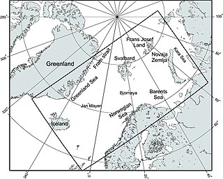
The Nordic Seas are located north of Iceland and south of Svalbard. They have also been defined as the region located north of the Greenland-Scotland Ridge and south of the Fram Strait-Spitsbergen-Norway intersection. Known to connect the North Pacific and the North Atlantic waters, this region is also known as having some of the densest waters, creating the densest region found in the North Atlantic Deep Water. The deepest waters of the Arctic Ocean are connected to the worlds other oceans through Nordic Seas and Fram Strait. There are three seas within the Nordic Sea: Greenland Sea, Norwegian Sea, and Iceland Sea. The Nordic Seas only make up about 0.75% of the World's Oceans. This region is known as having diverse features in such a small topographic area, such as the mid oceanic ridge systems. Some locations have shallow shelves, while others have deep slopes and basins. This region, because of the atmosphere-ocean transfer of energy and gases, has varying seasonal climate. During the winter, sea ice is formed in the western and northern regions of the Nordic Seas, whereas during the summer months, the majority of the region remains free of ice.

The Mediterranean Outflow is a current flowing from the Mediterranean Sea towards the Atlantic Ocean through the Strait of Gibraltar. Once it has reached the western side of the Strait of Gibraltar, it divides into two branches, one flowing westward following the Iberian continental slope, and another returning to the Strait of Gibraltar circulating cyclonically. In the Strait of Gibraltar and in the Gulf of Cádiz, the Mediterranean Outflow core has a width of a few tens of km. Through its nonlinear interactions with tides and topography, as it flows out of the Mediterranean basin it undergoes such strong mixing that the water masses composing this current become indistinguishable upon reaching the western side of the strait.
Open ocean convection is a process in which the mesoscale ocean circulation and large, strong winds mix layers of water at different depths. Fresher water lying over the saltier or warmer over the colder leads to the stratification of water, or its separation into layers. Strong winds cause evaporation, so the ocean surface cools, weakening the stratification. As a result, the surface waters are overturned and sink while the "warmer" waters rise to the surface, starting the process of convection. This process has a crucial role in the formation of both bottom and intermediate water and in the large-scale thermohaline circulation, which largely determines global climate. It is also an important phenomena that controls the intensity of the Atlantic Meridional Overturning Circulation (AMOC).
Phyllis Jean Stabeno is a physical oceanographer known for her research on the movement of water in polar regions. She has led award-winning research projects in the Arctic and was noted for a distinguished scientific career by the National Oceanic and Atmospheric Administration.

Cold and dense water from the Nordic Seas is transported southwards as Faroe-Bank Channel overflow. This water flows from the Arctic Ocean into the North Atlantic through the Faroe-Bank Channel between the Faroe Islands and Scotland. The overflow transport is estimated to contribute to one-third of the total overflow over the Greenland-Scotland Ridge. The remaining two-third of overflow water passes through Denmark Strait, the Wyville Thomson Ridge (0.3 Sv), and the Iceland-Faroe Ridge (1.1 Sv).

The Lofoten Vortex, also called Lofoten Basin Vortex or Lofoten Basin Eddy, is a permanent oceanic anticyclonic eddy, located in the northern part of the Norwegian Sea, off the coast of the Lofoten archipelago. It was documented for the first time in the 1970s.
| International | |
|---|---|
| National | |
| Academics | |