Related Research Articles

Burnside Township is a township in Centre County, Pennsylvania, United States. It is part of the State College, Pennsylvania Metropolitan Statistical Area. It is located approximately at 41°08′03″N77°09′58″W. The CDP of Pine Glen is within Burnside Township. The population was 417 at the 2020 census.

Utah Valley is a valley in North Central Utah located in Utah County, and is considered part of the Wasatch Front. It contains the cities of Provo, Orem, and their suburbs, including Alpine, American Fork, Cedar Hills, Elk Ridge, Highland, Lehi, Lindon, Mapleton, Payson, Pleasant Grove, Salem, Santaquin, Saratoga Springs, Spanish Fork, Springville, Vineyard and Woodland Hills. It is known colloquially as "Happy Valley".

The Guidiville Rancheria of California are a Pomo tribe located in Mendocino County, California.

Lanfair Valley is located in the Mojave Desert in southeastern California near the Nevada state line. It is bounded on the north by the New York Mountains and Castle Mountains, on the east by the Piute Range, and on the south by the Woods Mountains and Vontrigger Hills. Joshua Trees can be found in most of the valley. Elevation is 4,045 feet.
The Steptoe Valley is a long basin located in White Pine County, in northeastern Nevada in the western United States. From the historic community of Currie, the valley runs south for approximately 100 miles (160 km). To the west are the high Egan Range and the Cherry Creek Range, while to the east is the even higher Schell Creek Range. U.S. Route 93 passes through much of the northern section of the valley, past the historic mining town of Cherry Creek and the communities of McGill and Ely, before crossing the Schell Creek Range at Connors Pass. Also found in this valley are the Ward Charcoal Ovens State Historic Park, the Steptoe Valley Wildlife Management Area, and Cave Lake State Park. At Egan Canyon and Schellbourne Pass, the Overland Stage Line and the subsequent Pony Express and Transcontinental Telegraph made their way through the mountains of central Nevada in the 1860s.

The Mojave Road, also known as Old Government Road, is a historic route and present day dirt road across what is now the Mojave National Preserve in the Mojave Desert in the United States. This rough road stretched 147 miles (237 km) from Beale's Crossing, to Fork of the Road location along the north bank of the Mojave River where the old Mojave Road split off from the route of the Old Spanish Trail/Mormon Road.
The Black Mountains of northwest Arizona are an extensive, mostly linear, north-south trending 75 miles (121 km) long mountain range. It forms the north-south border of southwest Mohave County as it borders the eastern shore of the south-flowing Colorado River from Hoover Dam.

The Parker Valley is located along the Lower Colorado River within the Lower Colorado River Valley region, in southwestern Arizona and southeastern California.
Huampara District is one of thirty-three districts of the province Yauyos in Peru.

The Cochetopa Hills are a ridge of uplands on the Continental Divide in Saguache County, southern Colorado, United States.
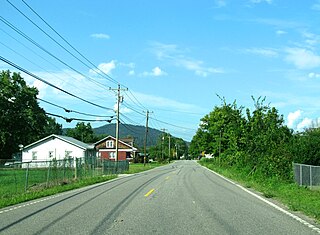
Newcomb is an unincorporated community in Campbell County, Tennessee, United States. It is situated in the Elk Fork Creek Valley in the Cumberland Mountains, southwest of Jellico. Tennessee State Route 297 passes through the community. The ZIP Code for Newcomb is 37819.
The Little Rincon Mountains are a small range of mountains, lying to the east of the Rincon Mountains, at Tucson, of eastern Pima County, Arizona. The range is located in northwest Cochise County and is part of the western border of the San Pedro River and Valley, the major valley and river of western Cochise County. The river is northward flowing to meet the Gila River; its headwaters are south of the US-Mexico border in northern Sonora. A small part of the Little Rincon range's southwest lies in Pima County.
The Cedar Mountain Range is a short 20 mi (32 km) long, mountain range in southwest Luna County, New Mexico, USA, just north of the Mexico–United States border with Chihuahua.

Diamond, also known as Caseyville, is an unincorporated community in southern Raccoon Township, Parke County, in the U.S. state of Indiana.

Gubesh Peak is the peak rising to 1407 m in Flowers Hills, Sentinel Range in Ellsworth Mountains, Antarctica. It surmounts Rutford Ice Stream to the east and Sikera Valley to the west.
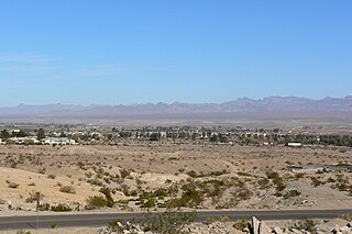
Pinto Valley is a basin in the Black Mountains of Clark County, Nevada. It lies at an elevation of 1,759 feet.
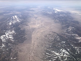
South Mountains are a range of mountains primarily in White Pine County, Nevada and partially to the east in Juab County, Utah. The range is sometimes referred to as the Deep Creek Mountains, or the Ibenpah Mountains. The South Mountains are divided from the Kern Mountains to the south by Tippett Canyon on the west and Pleasant Valley to the east. They are divided from the Deep Creek Range to the east in Utah by Johnson Canyon, on the north, and by Water Canyon on the south. The range is bounded on the north by Spring Creek Flat and on the west by Antelope Valley.
Pleasant Valley, is a valley in two counties in two states adjacent states, White Pine County, Nevada and Juab County, Utah. Its mouth is located at an elevation of 5,682 feet in Utah. Its head is at 39°44′09″N114°09′53″W at an elevation of 6,965 feet in Nevada. It lies between the Kern Mountains on the south, and South Mountains to the northwest and the Deep Creek Range on the north.
Tippett Canyon, is a valley whose creek drains the northwest watershed of the South Mountains in White Pine County, Nevada. Its mouth is at an elevation of 6,450 feet. Its source is at the head of the canyon near Cedar Pass, at an elevation of 6,649 feet at 39°46′04″N114°10′02″W.
Stoney Nakoda First Nation is a Nakoda First Nations band government Alberta, Canada. It is located West of Calgary, in the foot of the Rocky Mountains.
References
Coordinates: 39°45′49″N114°09′58″W / 39.76361°N 114.16611°W
| | This White Pine County, Nevada state location article is a stub. You can help Wikipedia by expanding it. |