The Shoshone or Shoshoni are a Native American tribe with four large cultural/linguistic divisions:

The Raft River is a 108-mile-long (174 km) tributary of the Snake River located in northern Utah and southern Idaho in the United States. It is part of the Columbia River Basin.
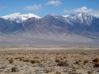
The Deep Creek Range, (often refereed to as the Deep Creek Mountains, are a mountain range in the Great Basin located in extreme western Tooele and Juab counties in Utah, United States. The range trends north–south, and is composed of granite in its central highest portion. The valley to the east is Snake Valley, and to the west is Deep Creek Valley. Nearby communities include Callao, Utah to the east and the community of Ibapah and the lands of the Confederated Tribes of the Goshute Reservation to the west.

The Greenhorn Mountains are a mountain range of the Southern Sierra Nevada, in California. They are protected within the Sequoia National Forest.

U.S. Route 50 (US 50) is a transcontinental highway in the United States, stretching from West Sacramento, California, in the west to Ocean City, Maryland, on the east coast. The Nevada portion crosses the center of the state and was named "The Loneliest Road in America" by Life magazine in July 1986. The name was intended as a pejorative, but Nevada officials seized it as a marketing slogan. The name originates from large desolate areas traversed by the route, with few or no signs of civilization. The highway crosses several large desert valleys separated by numerous mountain ranges towering over the valley floors, in what is known as the Basin and Range province of the Great Basin.

Eskdale is an unincorporated community in western Millard County, Utah, United States, just east of the Nevada border.

The Tushar Mountains are the third-highest mountain range in Utah after the Uinta Mountains and the La Sal Range. Located in the Fishlake National Forest, Delano Peak, 12,174 ft NAVD 88, is the highest point in both Beaver and Piute counties and has a prominence of 4,689 ft. Delano Peak is named for Columbus Delano (1809–1896), Secretary of the Interior, during the Grant administration. The Tushars receive an ample amount of snow annually even though they are situated within the rainshadow of the Sierra Nevada range in California and the Snake Range located in Nevada.

The South Fork Kern River is a tributary of the Kern River in the Sierra Nevada of the U.S. state of California. It is one of the southernmost rivers on the western slope of the mountains, and drains a high, relatively dry plateau country of 982 square miles (2,540 km2) along the Sierra Crest. The upper South Fork flows through a series of rugged canyons, but it also drains a flat, marshy valley before joining the Kern River at Lake Isabella.

U.S. Route 6 (US 6) is a United States Numbered Highway, stretching from Bishop, California in the west to Provincetown, Massachusetts on the East Coast. The Nevada portion crosses the center of the state, serving the cities of Tonopah and Ely, en route to Utah and points further east. Like US 50 to the north, large desolate areas are traversed by the route, with few or no signs of civilization, and the highway crosses several large desert valleys separated by numerous mountain ranges towering over the valley floors in what is known as the Basin and Range Province of the Great Basin.
The Fortification Range is a mountain range in Lincoln and White Pine counties, Nevada. The range is a narrow linear range trending north-northwest with a length of 34 km (21 mi) and a width of about 8 km (5.0 mi). It is typical of the Basin and Range Province.
Gandy is an unincorporated community in the northwestern corner of Millard County, Utah, United States, located just east of the Nevada-Utah state line.

Wah Wah Valley is an endorheic valley within the Basin and Range of west-central Utah, United States.
The Antelope Valley of southwest Millard County, Utah, United States, is a small 25-mile (40 km) long valley, adjacent the Ferguson Desert and 40 miles (64 km) southwest of Sevier Lake. The valley is just east of the Nevada border, with Snake Valley and the Burbank Hills. The other Antelope Valley of Utah occurs 165 miles (266 km) east in the Great Basin, in southeast Emery County and extending into adjacent Wayne County.

Hamlin Valley is a mostly north-south trending valley of the Great Basin located on both sides of the Nevada–Utah state line. It is about 60 miles (97 km) long. Its north-northeast end point adjacent the state line is the southwest start region of the Snake Valley.
The East Tintic Mountains are a mountain range in central Juab, Utah, and Tooele counties in Utah, United States on the east margin of the Great Basin just west of the Wasatch Front about 50 miles (80 km) south-southeast of Salt Lake City. The community of Eureka is an old mining town near the center of the range. U.S. Route 6 Passes through the central part of the range and through Eureka.
The West Hills are a 20-mile long (32 km) mountain range located in northeast Box Elder County, Utah, United States, that extends slightly north into Oneida County, Idaho. The range is connected to the Samaria Mountains, a small range on the north in southern Idaho. The West Hills are also connected to another section on the southwest, the Blue Spring Hills. West of the Blue Spring and West Hills is a long north–south valley, the Blue Creek Valley.
Deep Creek Valley is a 35-mile (56 km) long valley located in southwest Tooele County at the Utah-Nevada border; the extreme south of the valley is in northwest Juab County. The valley parallels the west flank of the Deep Creek Range, both north-trending. In the north-northeast, its outlet widens into the southwest of the Great Salt Lake Desert region.
South Mountains are a range of mountains primarily in White Pine County, Nevada and partially to the east in Juab County, Utah. The range is sometimes referred to as the Deep Creek Mountains, or the Ibenpah Mountains. The South Mountains are divided from the Kern Mountains to the south by Tippett Canyon on the west and Pleasant Valley to the east. They are divided from the Deep Creek Range to the east in Utah by Johnson Canyon, on the north, and by Water Canyon on the south. The range is bounded on the north by Spring Creek Flat and on the west by Antelope Valley.
The Raft River Valley is a valley in Cassia County, Idaho and Box Elder County, Utah in the United States.

Cirque Peak is a 12,900-foot-elevation (3,900-meter) mountain summit located on the crest of the Sierra Nevada mountain range in California. It is situated on the common border of Tulare County with Inyo County, as well as the shared boundary of Golden Trout Wilderness and John Muir Wilderness, on land managed by Inyo National Forest. It is 14 miles (23 km) southwest of the community of Lone Pine, 7.7 miles (12.4 km) south-southeast of Mount Whitney, and 3.2 miles (5.1 km) south of Mount Langley, the nearest higher neighbor. Cirque Peak is the highest point of the Golden Trout Wilderness, and ranks as the 175th highest peak in California. Topographic relief is significant as it rises 1,800 feet above Cirque Lake in approximately one mile. The Pacific Crest Trail traverses the southwest slope of this mountain, providing an approach option. The mountain was apparently named in 1890 by Joseph Nisbet LeConte and companions who noted the remarkable cirque on the north aspect.

